

Evaluation of China’s automatic earthquake information release system
-
摘要: 对全国自动地震速报系统进行了初步的评估. 通过2010年1月1日—2011年12月31日的自动定位结果与全国正式目录的对比, 分别得出了3套自动定位系统总体误差以及全国和全球的误差插值图, 并对结果进行了总结. 同时, 还针对3套自动定位系统的漏报和误报情况进行了分析和讨论. 总体来说, 现阶段自动地震速报系统整体上对于首都圈地区M≥3.0, 国内其它地区M≥4.0(部分台站稀疏的西部地区M≥5.0), 国外M≥7.0的地震基本可以达到全面覆盖的程度, 可以作为正式地震速报的参考, 对于建立“自动报—正式报”的两级地震速报制度能提供有力的技术支撑.Abstract: The paper presents an overall preliminary evaluation of China’s automatic earthquake information release system. By comparing the results based on automatic earthquake locating system with officially published earthquake catalog from Jan. 1, 2010 to Dec. 31, 2011, we calculated respectively the overall errors of 3 automatic locating systems and plotted interpolated error distribution in China and the whole world, and summarized the results. We also analyzed and discussed the issue of false alarm and missing report for the 3 systems. In general, the present earthquake information auto-release system in China can locate earthquakes with M≥3.0 in the Capital region, M≥4.0 in other areas of China (M≥5.0 in parts of western China where stations are sparse), and M≥7.0 outside China, and the “auto--results” can be used as reference for formal earthquake information release. The whole system is able to provide technical platform effectively for establishing a 2-step (i.e., auto-formal) earthquake information release system.
-
本目录中的地震参数来自“中国地震台站观测报告”(简称“月报”). 其中, 国内及邻区给出M≥4.7的事件, 全球给出M≥6.0的事件. “月报”由中国地震台网中心按月做出.
本目录中的发震时刻采用协调世界时(UTC); 为了方便中国读者, 也给出北京时(BTC). 震中位置除给出经纬度外, 还给出参考地区名, 它仅用作查阅参考, 不包含任何政治意义; 还给出测定震源位置的台数(n)和标准偏差(SD).
面波震级MS是用中周期宽频带SK地震仪记录, 采用北京台1965年面波震级公式MS=lg(AH/T)+1.66 lg(Δ)+3.5 (1°<Δ<130°)求得. AH是两水平分向最大面波位移的矢量合成位移. MS7是对763长周期地震仪记录, 采用国际上推荐的面波震级公式MS7=lg(AV/T)+1.66 lg(Δ)+3.3 (20°<Δ<160°)求得. AV是垂直向面波最大地动位移. mb是短周期体波震级, ML是近震震级, 为避免混乱, 震级之间一律不换算.
表 1 中国及邻区地震目录(2015年9—10月, M≥4.7)Table 1. Catalog of earthquakes within and near China (September--October, 2015, M≥4.7)编号 发 震 时 刻 地 理 坐 标 深度/km 震级 标准偏差(SD) 使用台数 (n) 地 区 UTC BTC 日-时 纬度/°N 经度/°E M S M S7 ML mb 月-日 时:分:秒 1 09-01 13:24:44.8 01-21 23.93 121.54 10 5.2 5.1 5.2 4.7 2.3 96 台湾岛 2 01 17:34:06.8 02-01 24.06 122.41 21 4.7 4.6 4.4 4.4 2.0 76 台湾岛 3 13 07:51:10.8 13-15 45.08 91.52 7 4.7 4.3 5.0 4.6 2.2 69 新疆自治区北部 4 15 19:37:33.2 16-03 24.35 121.90 10 5.6 5.5 5.7 5.0 1.6 98 台湾岛 5 16 11:10:07.7 16-19 35.46 78.47 8 4.5 4.2 4.9 4.6 2.2 66 克什米尔东部 6 16 13:08:57.1 16-21 24.25 121.90 10 5.3 5.2 5.4 4.9 1.6 101 台湾岛 7 10-12 10:04:14.7 12-18 34.36 98.20 10 5.3 5.1 5.1 4.9 2.6 92 青海省 8 12 11:14:46.8 12-19 22.47 121.48 12 4.7 4.4 4.9 4.5 1.7 84 台湾地区 9 19 02:17:36.1 19-10 24.93 122.00 10 5.5 5.3 5.6 4.9 1.9 97 台湾岛 10 19 05:42:13.1 19-13 24.97 121.79 10 4.7 4.5 4.5 4.4 2.2 71 台湾岛 11 19 07:20:16.7 19-15 24.98 121.99 10 4.7 4.5 4.6 4.4 1.9 73 台湾岛 12 21 05:58:21.0 21-13 44.68 124.16 10 4.5 4.3 5.1 4.3 2.0 50 中国东北部 13 26 18:11:23.8 27-02 30.17 98.01 6 4.6 4.4 4.4 4.7 2.3 58 西藏自治区 14 28 20:12:08.5 29-04 27.55 100.30 10 4.8 4.6 4.5 4.5 2.5 78 云南省 15 30 11:26:39.4 30-19 25.04 99.44 10 5.0 4.7 5.1 4.7 2.5 84 缅甸—中国边境地区 表 2 全球地震目录(2015年9—10月, M≥6.0)Table 2. Catalog of earthquakes all over the world (September--October, 2015, M≥6.0)编号 发 震 时 刻 地 理 坐 标 深度/km 震级 标准偏差(SD) 使用台数 (n) 地 区 UTC BTC 日-时 纬度/° 经度/° MS MS7 mb 月-日 时:分:秒 1 09-01 15:25:06.6 01-23 31.19N 141.88E 20 6.1 5.9 5.3 1.6 67 本州以南地区 2 07 09:13:56.6 07-17 33.07S 177.99W 29 6.2 5.9 5.4 1.7 74 克马德克群岛以南地区 3 07 14:06:24.7 07-22 32.98S 177.83W 12 6.0 5.7 5.3 1.9 84 克马德克群岛以南地区 4 08 08:03:55.0 08-16 14.70N 93.90W 10 6.0 5.7 1.4 56 墨西哥恰帕斯海岸近海 5 10 10:26:42.3 10-18 52.46N 169.64W 18 6.0 5.9 5.6 1.1 98 福克斯群岛 6 13 08:14:10.0 13-16 25.14N 109.38W 10 6.8 6.7 5.5 2.6 64 加利福尼亚湾 7 16 07:40:57.5 16-15 1.89N 126.42E 50 6.1 6.0 5.7 1.3 101 马鲁古海峡 8 16 14:03:21.7 16-22 6.03S 151.48E 20 6.0 5.8 5.3 1.6 102 新不列颠地区 9 16 22:54:31.5 17-06 31.59S 71.62W 20 8.3 8.3 1.3 80 中智利海岸近海 10 16 23:18:40.3 17-07 31.45S 71.20W 30 6.8 6.8 2.3 91 中智利海岸近海 11 17 01:41:10.2 17-09 31.10S 71.45W 40 6.4 6.4 1.4 88 中智利海岸近海 12 17 03:55:17.5 17-11 31.10S 71.35W 40 6.5 6.5 1.9 67 中智利海岸近海 13 17 04:10:27.7 17-12 31.55S 71.70W 30 6.9 6.9 2.8 94 中智利海岸近海 14 18 09:10:50.0 18-17 32.25S 72.10W 25 6.3 6.3 2.3 93 中智利海岸近海 15 18 15:59:42.5 18-23 15.30N 46.00W 10 6.2 6.0 2.5 53 北大西洋海岭 16 19 12:52:19.7 19-20 32.25S 71.80W 10 6.4 6.4 1.4 99 中智利海岸近海 17 19 13:08:56.5 19-21 30.89S 72.68W 10 6.3 6.0 3.1 37 中智利海岸近海 18 21 05:39:32.6 21-13 31.55S 71.70W 20 6.2 6.1 1.2 92 中智利海岸近海 19 21 17:39:57.4 22-01 31.65S 71.60W 20 6.8 6.8 1.3 95 中智利海岸近海 20 24 15:53:28.8 24-23 0.55S 131.25E 30 6.5 6.2 5.9 1.3 97 西伊里安地区 21 24 15:56:53.8 24-23 9.81S 160.70E 18 6.4 6.2 5.9 0.7 71 所罗门群岛 22 26 02:51:15.7 26-10 30.80S 71.30W 30 6.3 6.3 1.2 102 中智利海岸近海 23 10-11 00:58:29.0 11-08 54.60S 135.80W 10 6.0 5.8 3.0 40 南太平洋山系 24 14 05:43:04.0 14-13 48.88N 156.25E 10 6.3 6.3 5.6 1.3 99 千岛群岛 25 17 11:33:08.0 17-19 24.89S 64.31W 10 6.0 5.9 2.2 74 阿根廷萨尔塔省 26 20 21:52:0.0 21-05 14.82S 167.32E 130 6.2 1.3 82 瓦努阿图(新赫布里底) 27 26 09:09:31.2 26-17 36.59N 70.79E 207 6.1 0.9 94 兴都库什地区 -
![]()
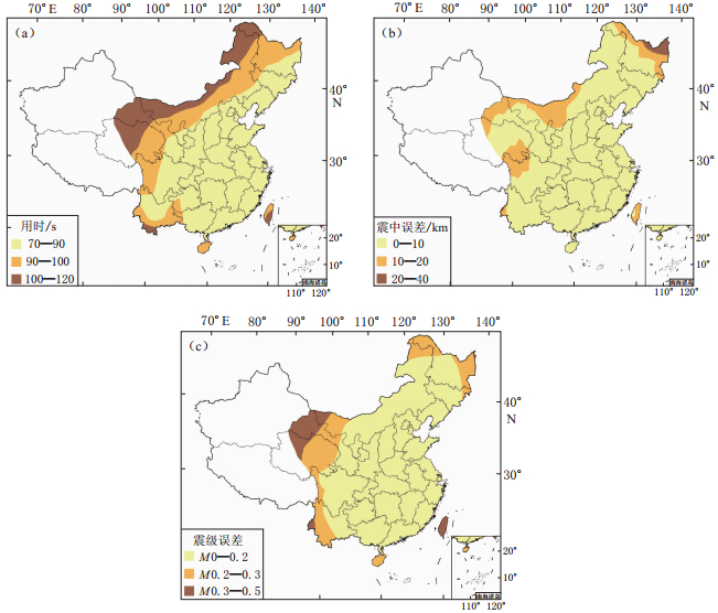
图 4 五大区域自动地震速报分中心误差插值图(a) 速报用时; (b) 震中误差; (c) 震级误差
Figure 4. Interpolated error distribution of the 5 regional earthquake information auto-release centers (a) Process time; (b) Epicenter error; (c) Magnitude error
![]()
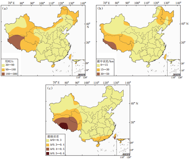
图 5 国家地震台网中心国内地震误差插值图(a) 速报用时; (b) 震中误差; (c) 震级误差
Figure 5. Interpolated error distribution for earthquakes in China by China Earthquake Networks Center (CENC) (a) Process time; (b) Epicenter error; (c) Magnitude error
![]()
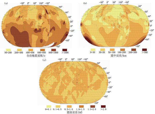
图 6 国家地震台网中心全球地震误差插值图(a) 速报用时; (b) 震中误差; (c) 震级误差
Figure 6. Interpolated error distribution for earthquakes around the world located by CENC (a) Process time; (b) Epicenter error; (c) Magnitude error
![]()
图 7 国家地震速报备份中心国内地震误差插值图(a) 速报用时; (b) 震中误差; (c) 震级误差
Figure 7. Interpolated error distribution for earthquakes in China located by the National Earthquake Backup Center(a) Process time; (b) Epicenter error; (c) Magnitude error
![]()
图 8 国家地震速报备份中心全球地震误差插值图(a) 速报用时; (b) 震中误差; (c) 震级误差
Figure 8. Interpolated error distribution for global earthquakes reported by the National Earthquake Backup Center(a) Process time; (b) Epicenter error; (c) Magnitude error
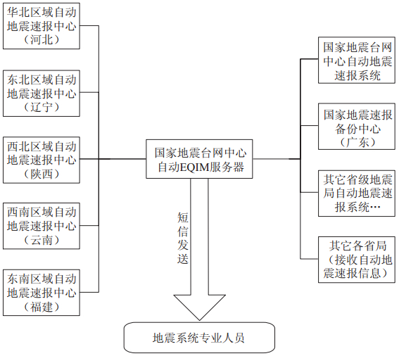
表 1 五大区域自动地震速报分中心相关信息
Table 1 Information of the 5 regional earthquake information auto-release centers

 下载: 导出CSV
-
国家质量技术监督局. 1999. 中华人民共和国国家标准(GB17740-1999): 地震震级的规定[S]. 北京: 中国标准出版社: 1-2. 杨陈, 黄志斌, 廖诗荣, 黄文辉, 翟璐媛. 2010. 全国自动地震速报系统介绍[J]. 地震地磁观测与研究, 31(5): 158-161. 中国地震局监测预报司. 2009. 自动地震速报技术管理规定(试行)(135)[S]. 北京: 中国地震局: 1-3.


计量
- 文章访问数: 675
- HTML全文浏览量: 273
- PDF下载量: 8
