

Empirical relationships of earthquake magnitudes for local regions considering the active tectonic boundary areas
-
摘要: 地方性震级ML和面波震级MS是两种常用的震级标度, 二者经常需要依据经验公式进行相互转换. 基于历史地震整体统计的经验公式由于资料有限, 且没有考虑区域地质条件的差异, 在实际使用中所产生的误差较大. 本文整理了40多年来同时包含ML和MS的1万2621条历史地震数据, 通过回归分析得到了震级ML与MS的经验关系; 并进一步按照震源所处的Ⅱ级活动地块边界带进行了分区回归分析, 得到了27个分区内地震震级ML与MS的经验关系. 结果显示, 经过分区转换后的ML与MS具有更好的相关性, 且考虑活动地块边界带所获取的地震震级能有效地降低ML与MS之间的转换误差.Abstract: Local magnitude ML and surface wave magnitude MS are two widely used scales of earthquake magnitude, which usually need to be converted to each other using empirical equations. Due to a limit of data, and ignorance the difference in geological conditions, empirical equations based on historical earthquakes suffer from conversion errors in practice. Based on the historical earthquake data of 12 621 records with both ML and MS recorded in the past four decades, this paper derived the empirical conversion equations between ML and MS by regression analysis. Furthermore, empirical conversion equations were derived from the partitioned data for the 27 regions classified according to the secondary active tectonic boundary areas. The results show that the correlation between MS and ML is more significant after the magnitude data are partitioned, and the magnitudes that were converted with consideration of active tectonic boundaries showed lower conversion error.
-
-
![]()
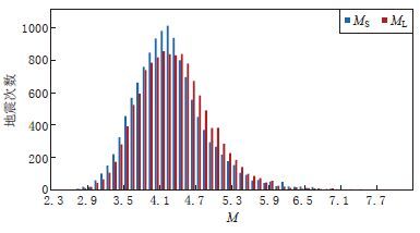
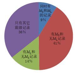
图 2 同时具有MS和ML记录的地震震级分布
Figure 2. Distribution of magnitudes of the earthquake events with both MS and ML records
![]()
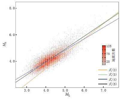
图 3 MS与ML震级的经验关系
The orange and the green lines represent the empirical equations from Eqs.(2)and(3),respectively. The blue and the black lines represents the linear regres- sion relations from Eqs.(4)and(5),respectively
Figure 3. Empirical relationships between MS and ML
![]()
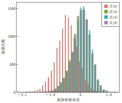
图 4 基于MS和ML共有记录得到的4组线性经验关系的误差分布
Figure 4. The error distribution of the four linear empirical relationships based on the records with both MS and ML
![]()
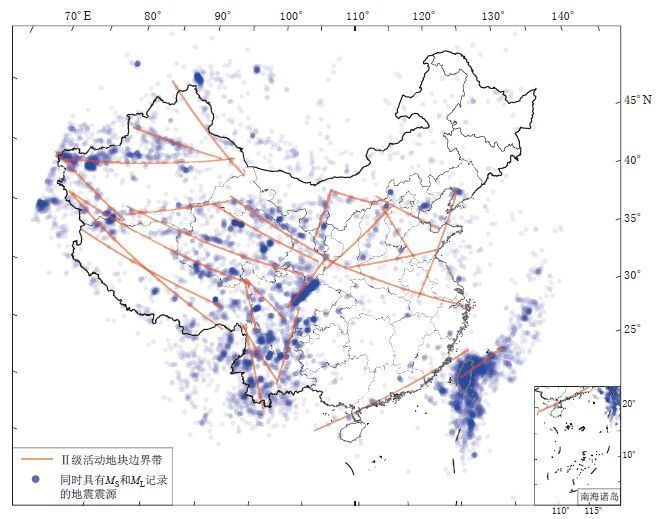
图 5 活动地块及其边界带
The red segments mark the approximate areas covered by each active tectonic boundary,and the blue dots represent the sources of earthquake events with both MS and ML records
Figure 5. Active tectonic blocks and their boundary areas
![]()
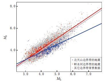
图 6 基于鲜水河边界带和北天山边界带地震数据 分别拟合得到的MS与ML经验关系曲线
The red dots represent earthquake data from Xianshuihe boundary area,the blue dots represent data from northern Tianshan boundary area,and the grey dots represent data from other areas
Figure 6. Empirical relationships fitting between MSand ML based on the earthquake data within Xianshuihe and northern Tianshan boundary areas
![]()
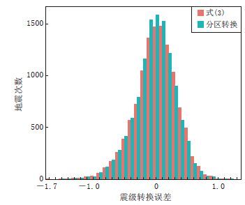
图 7 按边界带分区计算结果与式(3)计算结果的误差分布对比
Figure 7. Comparison of the conversion error of equations taking active tectonic boundaries into consideration(red) with that by using Eq.(3)
表 1 活动地块边界带及分区标准
Table 1 Active tectonic boundary areas and their classification criteria
边界带名称 边界带两侧活动地块 起始东经/° 终止东经/° 起始北纬/° 终止北纬/° 分区标准 燕山渤海 华北-东北亚(东段) 112.6 120.2 40.9 37.4 -0.46λ+91.26 <φ <-0.46λ+94.26 阴山 华北-东北亚(西段) 107.1 112.9 41.4 40.1 -0.22λ+63.91 <φ <-0.22λ+66.91 贺兰山 华北-西域 105.2 107.1 36.8 41.5 -2.47λ+300.23<φ <-2.47λ+303.23 岷山—龙门山 青藏-南华(北段) 102.7 106.6 30.3 35.1 1.23λ-97.6<φ <1.23λ-94.6 安宁河—小江 青藏-南华(南段) 102.1 104.0 23.2 30.5 3.84λ-370.58<φ <3.84λ-367.58 红河 青藏-滇缅 97.8 102.2 28.6 23.5 -1.16λ+140.46<φ <-1.16λ+143.36 海原—祁连 青藏-西域(东段) 94.7 106.4 40.1 35.3 -0.41λ+77.45<φ <-0.41λ+80.45 阿尔金 青藏-西域(中段) 82.9 94.7 36.3 39.6 0.28λ+11.62<φ <0.28λ+14.62 西昆仑 青藏-西域(西段) 72.6 83.0 39.8 35.8 -0.38λ+66.22<φ <-0.38λ+69.22 汾渭 鄂尔多斯-华北平原 106.4 114.4 33.9 39.8 0.74λ-46.07<φ <0.74λ-43.07 秦岭—大别山 华北-南华(东段) 106.4 122.8 35.1 29.7 -0.33λ+68.63<φ <-0.33λ+71.63 郯庐 华北平原-鲁东黄海 116.9 122.9 31.2 41.0 1.63λ-161.24<φ <1.63λ-158.24 东南沿海 华南-南海 106.0 121.7 19.2 26.0 0.43λ-28.21<φ <0.43λ-25.21 喜马拉雅 拉萨地块南缘 75.8 96.1 36.8 27.7 -0.45λ+69.28<φ <-0.45λ+72.28 喀喇昆仑—嘉黎 拉萨-羌塘 78.6 95.7 33.8 29.8 -0.23λ+50.69<φ <-0.23λ+53.69 玛尼—玉树 羌塘-巴彦喀拉 76.3 98.4 36.7 32.2 -0.2λ+50.74<φ <-0.2λ+53.74 三江 羌塘-川滇 97.7 99.6 32.6 27.9 -2.47λ+272.78<φ <-2.47λ+275.78 鲜水河 巴颜喀拉-川滇 97.8 102.5 32.7 29.3 -0.72λ+101.95<φ <-0.72λ+104.95 东昆仑 巴颜喀拉-柴达木 82.8 104.2 37.1 33.5 -0.17λ+49.53<φ <-0.17λ+52.53 西秦岭—德令哈 祁连-柴达木 92.8 105.8 39.1 34.8 -0.33λ+68.3<φ <-0.33λ+71.3 南天山 塔里木-天山 73.7 94.6 39.3 43.6 0.21λ+22.64<φ <0.21λ+25.64 北天山 天山-准噶尔 80.9 92.9 44.2 43.4 -0.07λ+48.09<φ <-0.07λ+51.09 富蕴 准噶尔-阿尔泰 84.2 96.1 49.4 42.1 -0.61λ+99.55<φ <-0.61λ+102.55 澜沧江 滇西-滇南 98.3 101.0 28.5 20.9 -2.81λ+303.7<φ <-2.81λ+306.7 河北平原 Ⅲ级块体边界 113.4 116.8 39.9 35.0 -1.44λ+201.83<φ <-1.44λ+204.83 安阳—菏泽—临沂 Ⅲ级块体边界 109.4 119.4 34.3 35.5 0.12λ+19.67<φ <0.12λ+22.67 台湾 板块边界 120.5 125.2 23.5 25.8 0.48λ+32.8<φ <0.48λ+35.8 注: λ和φ分别表示任一国内地震震中位置的经度和纬度,活动地块边界带张国民等(2005)  下载: 导出CSV
表 2 不同活动地块边界带分区地震MS与ML的经验关系
Table 2 Empirical relationships between MS and ML for different active tectonic boundary areas
边界带名称 边界带两侧活动地块 地震次数 r Δr 回归公式 燕山渤海 华北-东北亚(东段) 112 0.901 0.067 MS=0.1+0.92ML 阴山 华北-东北亚(西段) 90 0.921 0.087 MS=0.05+0.93ML 贺兰山 华北-西域 110 0.895 0.061 MS=0.37+0.84ML 岷山—龙门山 青藏-南华(北段) 1380 0.914 0.080 MS=-0.03+0.99ML 安宁河—小江 青藏-南华(南段) 668 0.872 0.038 MS=0.01+0.98ML 红河 青藏-滇缅 379 0.868 0.034 MS=0.2+0.97ML 海原—祁连 青藏-西域(东段) 314 0.907 0.073 MS=0.11+0.93ML 阿尔金 青藏-西域(中段) 253 0.870 0.036 MS=0.44+0.84ML 西昆仑 青藏-西域(西段) 561 0.808 -0.026 MS=0.42+0.86ML 汾渭 鄂尔多斯-华北平原 560 0.928 0.094 MS=-0.01+0.98ML 秦岭—大别山 华北-南华(东段) 81 0.867 0.033 MS=0.3+0.88ML 郯庐 华北平原-鲁东黄海 70 0.789 -0.045 MS=0.68+0.77ML 东南沿海 华南-南海 482 0.839 0.005 MS=0.12+0.95ML 喜马拉雅 拉萨地块南缘 476 0.760 -0.074 MS=0.2+0.94ML 喀喇昆仑—嘉黎 拉萨-羌塘 270 0.799 -0.035 MS=0.37+0.93ML 玛尼—玉树 羌塘-巴彦喀拉 745 0.803 -0.031 MS=0.12+0.96ML 三江 羌塘-川滇 279 0.881 0.047 MS=0.29+0.96ML 鲜水河 巴颜喀拉-川滇 318 0.891 0.057 MS=0.17+0.98ML 东昆仑 巴颜喀拉-柴达木 1067 0.906 0.072 MS=-0.01+0.99ML 西秦岭—德令哈 祁连-柴达木 529 0.896 0.062 MS=0.04+0.96ML 南天山 塔里木-天山 826 0.812 -0.022 MS=0.63+0.8ML 北天山 天山-准噶尔 214 0.806 -0.028 MS=1.08+0.68ML 富蕴 准噶尔-阿尔泰 56 0.890 0.056 MS=1.02+0.7ML 澜沧江 滇西-滇南 199 0.858 0.024 MS=0.12+0.98ML 河北平原 Ⅲ级块体边界 55 0.928 0.094 MS=-0.03+0.96ML 安阳—菏泽—临沂 Ⅲ级块体边界 59 0.888 0.054 MS=0.44+0.83ML 台湾 板块边界 2422 0.849 0.015 MS=0.02+0.99ML 注: r表示各边界带分区内地震震级MS与ML的皮尔森相关系数; Δr表示由边界带分区内地震统计得到的相关系数与总体相关系数的差值.
下载: 导出CSV
-
郭履灿. 1971. 华北地区的地方性震级ML和面波震级MS经验关系[C]//全国地震工作会议:1-10 Guo L C. 1971. Empirical relationship of local magnitude ML and surface magnitude MS[C]//Conference Record of National Seismology Work:1-10
中国地震台网.2015. 国家台网大震速报目录[EB/OL]. [2015-01-14]. http:∥www.csndmc.ac.cn/newweb/data.htm. China Seismic Networks Center. 2015. China seismic networks earthquake catalogue[EB/OL]. [2015-01-14]. http:∥www.csndmc.ac.cn/newweb/data.htm.
Yenier E, Erdoǧan Ö ,Akkar S,2008.Empirical relationships for magnitude and source-to-site distance conversions using recently compiled Turkish strong-ground motion database[C]//Proceedings of the 14th World Conference on Earthquake Engineering. October 12-17 2008, Beijing, China.
计量
- 文章访问数: 586
- HTML全文浏览量: 262
- PDF下载量: 24
