

Seismic damage information extraction and evaluation of buildings with high resolution remote sensing based on object-oriented method
-
摘要: 为了快速地确定地震等自然灾害引起的受灾区域范围,并对其受灾程度进行及时评估,本文采用面向对象的建筑物检测方法,基于高分辨率遥感影像所包含的地物几何结构和纹理特征信息,提出了一种建筑物震害信息提取与评估的方法和技术流程.在此基础上,以2010年玉树MS7.1地震部分地区地震前后的QuickBird影像为例,对受灾区域震前、震后建筑物的形状、面积等信息进行提取,提取精度分别为88.53%和90.21%,对该区域建筑物变化信息进行提取所获取的建筑物变化信息精度为79.68%,统计变化区域像素个数,确定变化面积为15 923.52 m2,占研究区域总面积的68.16%,因此评估其为中重度受灾区域.本文结果与实地考察结果一致,证实了这种快速的震害信息提取与评估流程切实有效,能够快速评估受灾区,为灾后第一时间抢险及救援提供重要参考.Abstract: In order to rapidly determine the scope of stricken area and timely assess the extent of damages after an earthquake, this paper proposes a technical process of rapid extracting and evaluating building damage information by using the geometric structure and texture feature information of high resolution remote sensing images based on the object-oriented building detection method. The process can rapidly locate the disaster areas, which is of great significance to the post-disaster first opportunity rescue. Taking the Yushu area as an example, buildings of disaster area are extracted based on the QuickBird images before and after the Yushu earthquake, and the extraction precisions of buildings is 88. 53% and 90. 21%, respectively. The extraction accuracy of building changing information is 79. 68%, and changing area reaches 15 923. 52 m2, which accounts for 68. 16% of the entire studied area, therefore the area is evaluated as moderately-severe disaster area. The results of this paper are consistent with those of the field investigations, proving that the rapid seismic damage information extraction and evaluation process is effective. The presented method can quickly estimate the disaster areas, and provide an important reference for the first time rescue.
-
-
![]()
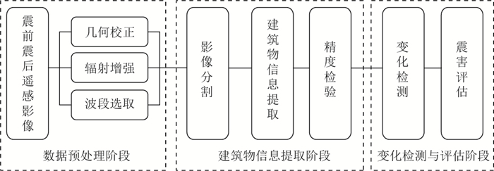
图 1 震害信息提取技术流程图
Figure 1. Technique flow chart of seismic damage information extraction
![]()
图 2 玉树震前(a)和震后(b)研究区的QuickBird影像
Figure 2. QuickBird images of the studied area before (a) and after (b) Yushu earthquake
![]()
图 3 玉树震后研究区的原始影像(a)和增强影像(b)
Figure 3. Comparison of post-seismic original image (a) with enhanced damage image (b) of the studied area after Yushu earthquake
![]()
图 4 分割尺度为50时不同窗口的影像分割结果
(a) 3像素×3像素;(b) 5像素×5像素;(c) 7像素×7像素;(d) 9像素×9像素
Figure 4. Image segmentation results with different window sizes in the segmentation scale of 50
(a) 3 pixel×3 pixel; (b) 5 pixel×5 pixel; (c) 7 pixel×7 pixel; (d) 9 pixel×9 pixel
![]()
图 5 5像素×5像素窗口下不同分割尺度Ω的分割影像结果
Figure 5. Image results of different segmentation scales Ω with window size of 5 pixel×5 pixel
(a) Ω=10; (b) Ω=20; (c) Ω=30; (d) Ω=40; (e) Ω=50; (f) Ω=60; (g) Ω=70; (h) Ω=80; (i) Ω=90
![]()
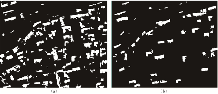
图 6 玉树震前(a)和震后(b)建筑物面向对象信息提取结果图
Figure 6. Building extraction results before (a) and after (b) Yushu earthquake by object-oriented method
![]()
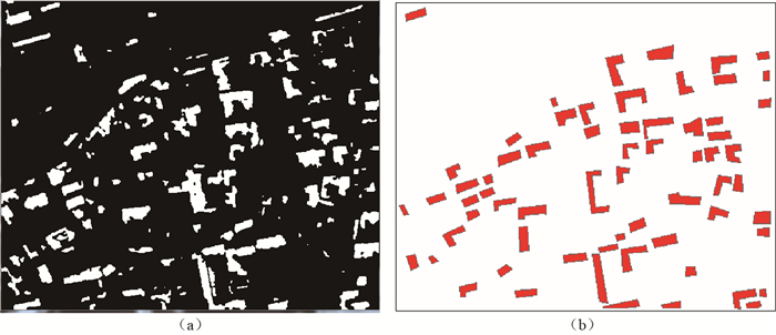
图 7 玉树地震前后建筑物变化区域(a)及目视解译研究区域建筑物实际变化区域(b)
Figure 7. Building changing area before and after Yushu earthquake (a) and actual building change area by visual interpretation (b)
表 1 遥感影像各波段光谱值的均值和标准差
Table 1 Mean and standard deviation of spectral value for each band of remote sensing image
波段 均值 标准差 1 371.055 46.603 2 599.912 80.027 3 494.232 68.796 4 559.778 78.544  下载: 导出CSV
表 2 遥感影像各波段光谱值相关性
Table 2 Correlation of spectral value for each band of remote sensing image
1波段 2波段 3波段 4波段 1波段 1.000 2波段 0.982 1.000 3波段 0.922 0.964 1.000 4波段 0.820 0.874 0.949 1.000
下载: 导出CSV
表 3 遥感影像各波段组合OIF指数值
Table 3 OIF value of each combined bands in remote sensing image
波段组合 OIF指数值 1-2-3 68.110 1-2-4 76.641 1-3-4 72.069 2-3-4 81.597
下载: 导出CSV
表 4 受灾程度分级表
Table 4 Classification of the extent of the disaster
面积变化 受灾等级 < 20% 未受损或轻度受损 20%-40% 轻中度受损 40%-60% 中度受损 60%-80% 中重度受损 >80% 重度受损或损毁
下载: 导出CSV
表 5 震前、震后建筑物变化量统计表
Table 5 Statistical of changing buildings before and after earthquake
震前建筑物 震前非建筑物 合计 震后建筑物 17.437% 4.798% 震后非建筑物 82.563% 95.202% 变化量 -57.286% 10.874% 68.16%
下载: 导出CSV
-
杜凤兰, 田庆久, 夏学齐, 惠凤鸣. 2004.面向对象的地物分类法分析与评价[J].遥感技术与应用, 19 (1): 20-23. http://www.cnki.com.cn/Article/CJFDTOTAL-YGJS200401005.htm Du F L, Tian Q J, Xia X Q, Hui F M. 2004. Object-oriented image classification analysis and evaluation[J]. Remote Sensing Technology and Application, 19 (1): 20-23 (in Chinese). http://www.cnki.com.cn/Article/CJFDTOTAL-YGJS200401005.htm
龚丽霞, 李强, 张景发, 曾琪明, 刘明众, 李成龙. 2013.面向对象的房屋震害变化检测方法[J].地震, 33 (2): 109-114. http://www.cnki.com.cn/Article/CJFDTOTAL-DIZN201302015.htm Gong L X, Li Q, Zhang J F, Zeng Q M, Liu M Z, Li C L. 2013. Object-oriented detection of earthquake building damages[J]. Earthquake, 33 (2): 109-114 (in Chinese). http://www.cnki.com.cn/Article/CJFDTOTAL-DIZN201302015.htm
黎小东. 2009.面向对象的高空间分辨率遥感影像城市建筑物震害信息提取:以汶川县城为例[D].成都:成都理工大学地球科学学院: 36-43. Li X D. 2009. Information Extraction of Damaged Town Buildings Caused by Earthquake With the Object-Oriented Method From High Spatial Resolution Image: A Case Study in Wenchuan Earthquake[D]. Chengdu: College of Earth Sciences, Chengdu University of Technology: 36-43 (in Chinese).
李小强. 2014.面向对象的高分辨率遥感影像建筑物震害信息提取研究[D].昆明:云南师范大学旅游与地理科学学院: 10-24. http://www.docin.com/p-1194166128.html Li X Q. 2014. Object-Oriented Method of Building Damage Extraction From High-Resolution Images[D]. Kunming: School of Tourism and Geographical Sciences, Yunnan Normal University: 10-24 (in Chinese). http://www.docin.com/p-1194166128.html
王晓青, 窦爱霞, 孙国清, 丁香, 王龙, 袁小祥. 2013.基于综合震害指数的玉树地震烈度遥感评估研究[J].地震, 33 (2): 1-10. http://www.cnki.com.cn/Article/CJFDTOTAL-DIZN201302002.htm Wang X Q, Dou A X, Sun G Q, Ding X, Wang L, Yuan X X. 2013. Intensity assessment of the 2010 Yushu MS7.1 earthquake based on synthetic seismic damage index[J]. Earthquake, 33 (2): 1-10 (in Chinese). http://www.cnki.com.cn/Article/CJFDTOTAL-DIZN201302002.htm
闻春晶, 赵书河, 李晖. 2010.面向对象的高分辨率遥感影像变化检测方法[J].山东师范大学学报:自然科学版, 25 (1): 126-129. http://d.wanfangdata.com.cn/Periodical/sdsdxb-zrkx201001034 Wen C J, Zhao S H, Li H. 2010. Object-oriented change detection method using very high spatial resolution imagery[J]. Journal of Shandong Normal University: Natural Science, 25 (1): 126-129 (in Chinese). http://d.wanfangdata.com.cn/Periodical/sdsdxb-zrkx201001034
颜洁, 刘建坡, 唐伟广. 2010.基于遥感图像变化检测的毁伤效果分析[J].信号与信息处理, 40 (4): 30-31. http://www.cnki.com.cn/Article/CJFDTOTAL-WXDG201004011.htm Yan J, Liu J P, Tang W G. 2010. The damage assessment based on remote sensing image change detection[J].Journal of Signal and Information Processing, 40 (4): 30-31 (in Chinese). http://www.cnki.com.cn/Article/CJFDTOTAL-WXDG201004011.htm
张景发, 谢礼立, 陶夏新. 2001.典型震害遥感图像的模型分析[J].自然灾害学报, 10 (2): 89-95. http://www.cnki.com.cn/Article/CJFDTOTAL-ZRZH200102014.htm Zhang J F, Xie L L, Tao X X. 2001. Pattern analysis of remote sensing imagery for some typical earthquake damages[J]. Journal of Natural Disasters, 10 (2): 89-95 (in Chinese). http://www.cnki.com.cn/Article/CJFDTOTAL-ZRZH200102014.htm
章毓晋. 2000.图像分割[M].北京:科学出版社: 55-70. Zhang Y J. 2000. Image Segmentation[M]. Beijing: Science Press: 55-70 (in Chinese).
Huyck C K, Adams B J, Cho S, Chung H C, Eguchi R T. 2005. Towards rapid citywide damage mapping using neighborhood edge dissimilarities in very high-resolution optical satellite imagery: Application to the 2003 Bam, Iran, earthquake[J]. Earthq Spectra, 21 (S1): 255-266. doi: 10.1193/1.2101907
Liu S C, Bruzzone L, Bovolo F, Du P J. 2015. Hierarchical unsupervised change detection in multitemporal hyperspectral images[J]. IEEE Trans Geosci Remote Sensing, 53 (1): 244-260. doi: 10.1109/TGRS.2014.2321277
Turker M, San B T. 2004. Detection of collapsed buildings caused by the 1999 Izmit, Turkey earthquake through digital analysis of post-event aerial photographs[J]. Int J Remote Sensing, 25 (21): 4701-4714. doi: 10.1080/01431160410001709976


计量
- 文章访问数: 746
- HTML全文浏览量: 330
- PDF下载量: 26
