

Atmospheric correction for InSAR and its application in mapping ground motion due to interseismic strain accumulation
-
摘要: 为了获取青藏高原东北缘老虎山断裂带精确的震间形变速率场,通过对短时间基线干涉图大气改正效果的评价,从3种外部大气数据(MERIS, ERA-Ⅰ, WRF)中确定出最优的大气改正方法,用于长时间基线干涉图中的大气信号改正;然后利用层叠法(stacking)累积平均经大气和轨道改正后的干涉图,获取了研究区的震间形变速率场.结果显示:海原断裂系统区域内,MERIS和ERA-Ⅰ的大气改正效果优于WRF;MERIS和ERA-Ⅰ的改正结果给出了相似的形变速率场,断层两盘相对形变速率为视线向2.5 mm/a,转换成平行于断层方向为6.5 mm/a,与GPS结果一致;在近断层5 km的范围内,出现了较大的形变梯度,揭示了浅层蠕滑的存在.Abstract: It is essential to correct the atmospheric error for measuring interseismic deformation in the order of mm/a. In this paper, Laohushan fault on the northeastern margin of the Tibetan Plateau is chosen as the study area. In order to derive the accurate interseismic deformation field, we evaluate three atmospheric correction methods (MERIS, ERA-Ⅰ, WRF) based on the corrected results on interferograms with small temporal-baselines. The optimal atmospheric correction methods and orbital correction methods are applied to correct errors in the large-temporal-baseline interferograms, then the average interseismic deformation fields are achieved by stacking the atmosphere and orbit-corrected interferograms. Our results show that the MERIS and ERA-Ⅰ are more suitable to be used to correct the atmospheric effect in ASAR interferograms than WRF in Haiyuan fault system area; on the other hand, the MERIS-corrected and ERA-Ⅰ-corrected deformation rate fields show a similar pattern of left-lateral displacement across the Laohushan fault, and the profiles across the fault show that the line-of-sight velocity across the fault is 2.5 mm/a, which is equal to 6.5 mm/a parallel to the fault and accords well with GPS observations. In addition, there is a large displacement gradient within 5 km near the fault, revealing shallow creep near the surface.
-
Keywords:
- InSAR /
- atmospheric correction /
- active fault /
- interseismic deformation /
- Laohushan fault
-
-
![]()
图 1 利用3种不同的大气改正方法获取的同一时刻同一区域的流体静力学延迟(a)和湿延迟(b)
Figure 1. Hydrostatic delay (a) and wet delay (b) for the same area at the same time based on three different atmospheric correction methods (MERIS, ERA-Ⅰ and WRF)
![]()
图 2 对比3种大气改正方法的流程图
Figure 2. Process flowchart for comparing three different atmospheric correction methods
![]()
图 3 基于3种大气改正方法的残差相位直方图
黑色叉号表示每幅图残差的频率分布(共7幅),红色曲线表示基于7幅图残差分布拟合的正态曲线
Figure 3. Histograms of residual phase from the results corrected by three different atmospheric correction methods
Black crosses are the frequency for each interferogram (seven in total), and red curves stand for the fitted normal curve of the residuals of the seven interferogams
![]()
图 4 海原断裂带的地质构造图和试验数据分布
背景为来自SRTM (Shuttle Radar Topography Mission)的高程,黑色虚线表示Envisat ASAR数据和MERIS数据的覆盖范围,黑色实线矩形框表示WRF第三层嵌套的范围,红色方块表示ERA-Ⅰ的数据分布
Figure 4. Tectonic map of the Haiyuan fault zone and distribution of test data
Fault traces are superimposed on SRTM DEM. The black dashed rectangle shows the coverage of Envisat ASAR data and MERIS data. The black solid rectangle stands for the coverage of WRF simulation. Red squares represent data from ERA-Ⅰ. And the epicenter of two large historical earthquakes are marked as magenta points
![]()
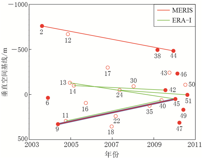
图 5 降轨数据061条带覆盖老虎山断裂的ASAR数据时空分布
红色圆圈表示条带内的雷达数据,其中红色实心圆表示无云情况.红线表示可由MERIS数据改正的长时间基线干涉图,绿线表示可由ERA-Ⅰ数据改正的长时间基线干涉图
Figure 5. Spatio-temporal baseline plot of Envisat ASAR acquisitions for descending track 061 covering the Laohushan fault
Acquisitions are numbered time sequentially, and 11 of them marked with red solid circle are largely cloud-free. The two long-temporal-baseline inter-ferograms denoted by red line are corrected for atmospheric effects using MERIS data, and the four long-temporal-baseline interferograms marked by green lines are corrected by using ERA-Ⅰ data
![]()
图 6 利用长时间基线干涉图获取震间形变场的流程
Figure 6. Flowchart of deriving interseismic deformation field based on long-temporal-baseline interferograms
![]()
图 7 以一个基于MERIS改正的干涉对(040522-100116,上)和基于ERA-Ⅰ改正的干涉对(041218-100116,下)为例展示图 6所示的形变速率场获取过程
从左至右分别为原始干涉图、湿延迟、流体静力学延迟、经过大气改正的干涉图、拟合得到的轨道误差和轨道改正后的残余误差
Figure 7. Deriving process of the deformation field from one interferogram pair (040522-100116, upper panels) corrected by MERIS data and the other one (041218-100116, lower panels) corrected by ERA-Ⅰ data as shown in Fig.6
From left to right, shown are original interferograms, the wet delay from MERIS and ERA-Ⅰ data, the hydrostatic delay from MERIS and ERA-Ⅰ data, the atmosphere-corrected interferograms, linear orbital ramp, and residual interferograms after orbital correction
![]()
图 8 InSAR震间形变场和形变场剖面线
(a)和(b)分别表示基于MERIS改正和ERA-Ⅰ改正的震间形变场,其中红色实线矩形框内的断层为老虎山断裂,红色虚线矩形框内的断层为景泰断裂;(c)和(d)分别表示速度场剖面线AA′和BB′平行于断层的水平运动速率,其中黄点和绿点分别表示基于MERIS和ERA-Ⅰ大气改正后的形变场在剖面线上的投影,而红线和黑线分别表示对应其平均值
Figure 8. Interseismic velocity field of study area and its two profiles across the fault
(a) The MERIS-corrected rate map; (b) The ERA-Ⅰ-corrected rate map. The red solid rectangle covers the Laohushan fault, and the red dashed rectangle covers the Jingtai fault; (c) The fault-parallel velocity of the AA′ profile from two rate maps; (d) The fault-parallel velocity of the BB′ profile from two rate maps. Black and green points are the projection of MERIS-corrected and ERA-Ⅰ-corrected rate map on the profile, and red line and black line are their mean values
-
崔喜爱, 曾琪明, 童庆禧, 焦健, 梁存任. 2014.重轨星载InSAR测量中的大气校正方法综述[J].遥感技术与应用, 29(1): 9-17. https://wenku.baidu.com/view/b0a587b8fab069dc51220108.html Cui X A, Zeng Q M, Tong Q X, Jiao J, Liang C R. 2014. Overview of the atmospheric correction methods in repeat-pass InSAR measurements[J]. Remote Sensing Technology and Application, 29(1): 9-17 (in Chinese). https://wenku.baidu.com/view/b0a587b8fab069dc51220108.html
代如锋. 2015. WRF模式在西北地区的适用性分析[C]//第32届中国气象学会年会: 军用数值天气预报技术及应用. 北京: 中国气象学会: 9. Dai R F. 2015. The applicability analysis of WRF model in northwest China[C]//The 32th Annual Meeting of Chinese Meteorological Society: Military Numerical Weather Forecast Techniques and Application. Beijing: Chinese Meteorological Society: 9 (in Chinese).
国家地震局地质研究所, 宁夏回族自治区地震局. 1990.海原活动断裂带[M].北京:地震出版社: 1-286. Institute of Geology of State Seismological Bureau, Seismological Bureau of Ningxia Hui Autonomous Region. 1990. The Haiyuan Active Fault Zone[M]. Beijing: Seismological Press: 1-286 (in Chinese).
王立稳, 杨军, 程菲. 2015.北天山东段一次暴雨过程的数值模拟研究:动力与微物理机制[J].科学技术与工程, 15(20): 201-211, 215 (in Chinese). doi: 10.3969/j.issn.1671-1815.2015.20.032 Wang L W, Yang J, Cheng F. 2015. Numerical study of a heavy rain process in the eastern part of North Tianshan Mountains: Kinematics and microphysical mechanism[J]. Science Technology and Engineering, 15(20): 201-211, 215. doi: 10.3969/j.issn.1671-1815.2015.20.032
Bekaert D P S, Walters R J, Wright T J, Hooper A J, Parker D J. 2015. Statistical comparison of InSAR tropospheric correction techniques[J]. Remote Sens Environ, 170: 40-47. doi: 10.1016/j.rse.2015.08.035
Bevis M, Businger S, Herring T A, Rocken C, Anthes R A, Ware R H. 1992. GPS meteorology: Remote sensing of atmospheric water vapor using the Global Positioning System[J]. J Geophys Res, 97(D14): 15787-15801. doi: 10.1029/92JD01517
Cavalié O, Lasserre C, Doin M P, Peltzer G, Sun J, Xu X, Shen Z K. 2008. Measurement of interseismic strain across the Haiyuan fault (Gansu, China), by InSAR[J]. Earth Planet Sci Lett, 275(3/4): 246-257. https://www.researchgate.net/publication/244540363_Measurement_of_interseismic_strain_across_the_Haiyuan_fault_Gansu_China_by_InSAR
Doin M P, Lasserre C, Peltzer G, Cavalié O, Doubre C. 2009. Corrections of stratified tropospheric delays in SAR interferometry: Validation with global atmospheric models[J]. J Appl Geophys, 69(1): 35-50. doi: 10.1016/j.jappgeo.2009.03.010
Farr T G, Rosen P A, Caro E, Crippen R, Duren R, Hensley S, Kobrick M, Paller M, Rodriguez E, Roth L, Seal D, Shaffer S, Shimada J, Umland J, Werner M, Oskin M, Burbank D, Alsdorf D. 2007. The Shuttle Radar Topography Mission[J]. Rev Geophys, 45(2): RG2004. https://en.wikipedia.org/wiki/Shuttle_Radar_Topography_Mission
Gan W J, Zhang P Z, Shen Z K, Niu Z J, Wang M, Wan Y G, Zhou D M, Cheng J. 2007. Present-day crustal motion within the Tibetan Plateau inferred from GPS measurements[J]. J Geophys Res, 112: B08416. doi: 10.1029/2005JB004120.
Gaudemer Y, Tapponnier P, Meyer B, Peltzer G, Guo S M, Chen Z T, Dai H G, Cifuentes I. 1995. Partitioning of crustal slip between linked, active faults in the eastern Qilian Shan, and evidence for a major seismic gap, the 'Tianzhu gap', on the western Haiyuan fault, Gansu (China)[J]. Geophys J Int, 120(3): 599-645. doi: 10.1111/j.1365-246X.1995.tb01842.x
Gong W, Meyer F J, Lee C W, Lu Z, Freymueller J. 2015. Measurement and interpretation of subtle deformation signals at Unimak Island from 2003 to 2010 using weather model-assisted time series InSAR[J]. J Geophys Res, 120(2): 1175-1194. doi: 10.1002/2014JB011384
Jolivet R, Agram P S, Lin N Y, Simons M K, Doin M P, Peltzer G, Li Z H. 2014. Improving InSAR geodesy using global atmospheric models[J]. J Geophys Res, 119(3): 2324-2341. doi: 10.1002/2013JB010588
Jolivet R, Lasserre C, Doin M P, Guillaso S, Peltzer G, Dailu R, Sun J, Shen Z K, Xu X. 2012. Shallow creep on the Haiyuan fault (Gansu, China) revealed by SAR interferometry[J]. J Geophys Res, 117: B06401. doi: 10.1029/2011JB008732.
Jung J, Kim D J, Park S E. 2014. Correction of atmospheric phase screen in time series InSAR using WRF model for monitoring volcanic activities[J]. IEEE Trans Geosci Remote Sens, 52(5): 2678-2689. doi: 10.1109/TGRS.2013.2264532
Li X, Rignot E, Morlighem M, Mouginot J, Scheuchl B. 2015. Grounding line retreat of Totten Glacier, East Antarctica, 1996 to 2013[J]. Geophys Res Lett, 42(19): 8049-8056. doi: 10.1002/2015GL065701
Li Z, Muller J P, Cross P, Albert P, Fischer J, Bennartz R. 2006. Assessment of the potential of MERIS near-infrared water vapour products to correct ASAR interferometric measurements[J]. Int J Remote Sens, 27(2): 349-365. doi: 10.1080/01431160500307342
Lindsey E O, Natsuaki R, Xu X H, Shimada M, Hashimoto M, Melgar D, Sandwell D T. 2015. Line-of-sight displacement from ALOS-2 interferometry: MW7.8 Gorkha earthquake and MW7.3 aftershock[J]. Geophys Res Lett, 42(16): 6655-6661. doi: 10.1002/2015GL065385
Liu-Zeng J, Klinger Y, Xu X W, Lasserre C, Chen G H, Chen W B, Tapponnier P, Zhang B. 2007. Millennial recurrence of large earthquakes on the Haiyuan fault near Songshan, Gansu Province, China[J]. Bull Seismol Soc Am, 97(1B): 14-34. doi: 10.1785/0120050118
Massonnet D, Feigl K, Rossi M, Adragna F. 1994. Radar interferometric mapping of deformation in the year after the Landers earthquake[J]. Nature, 369(6477): 227-230. doi: 10.1038/369227a0
Ramon D, Cazier L, Santer R. 2003. The surface pressure retrieval in the MERIS O2 absorption: Validation and potential improvements[C]//Proceedings of 2003 IEEE International Geoscience and Remote Sensing Symposium. Toulouse: IEEE, 5: 3126-3128.
Rosen P A, Hensley S, Peltzer G, Simons M. 2004. Updated repeat orbit interferometry package released[J]. Eos, 85(5): 47. https://www.researchgate.net/publication/248239882_Updated_Repeat_Orbit_Interferometry_Package_Released
Savage J C, Burford R O. 1973. Geodetic determination of relative plate motion in central California[J]. J Geophys Res, 78(5): 832-845. doi: 10.1029/JB078i005p00832
Su F G, Duan X L, Chen D L, Hao Z C, Cuo L. 2013. Evaluation of the global climate models in the CMIP5 over the Tibetan Plateau[J]. J Climate, 26(10): 3187-3208. doi: 10.1175/JCLI-D-12-00321.1
Wang C C, Mao X K, Wang Q J. 2016. Landslide displacement monitoring by a fully polarimetric SAR offset tracking method[J]. Remote Sens, 8(8): 624. doi: 10.3390/rs8080624
Zebker H A, Rosen P A, Hensley S. 1997. Atmospheric effects in interferometric synthetic aperture radar surface deformation and topographic maps[J]. J Geophys Res, 102(B4): 7547-7563. doi: 10.1029/96JB03804
Zhang Y H, Wu H A, Kang Y H, Zhu C G. 2016. Ground subsidence in the Beijing-Tianjin-Hebei region from 1992 to 2014 revealed by multiple SAR stacks[J]. Remote Sens, 8(8): 675. doi: 10.3390/rs8080675
-
期刊类型引用(47)
1. 李皎皎,张永军,何怡原,李逸川,李诗珺,陈瑶. 基于航磁与小震精定位结果研究断裂构造特征——以攀西地区为例. 物探与化探. 2025(01): 206-214 .  百度学术
百度学术
2. 吉宇,张广伟,任俊杰,何静,王肖薇. 基于背景噪声成像研究北京地区三维S波速度结构. 地震地质. 2025(01): 306-324 . 百度学术
3. 严少鹏,万永革. 2020年唐山古冶M5.1地震震源区小震震源机制和应力场的求解. 地震. 2025(01): 1-15 . 百度学术
4. 许永强,雷建设. 大同火山群及邻区中小地震重定位. 地震地质. 2024(02): 336-356 . 百度学术
5. 董春丽,张广伟,李欣蔚,王跃杰,丁大业,宫卓宏. 基于震源机制和地震定位研究2022年山西古交M_L4.1地震的发震构造. 地震地质. 2024(02): 414-432 . 百度学术
6. Jinxin Hou,Yunpeng Zhang,Liwei Wang,Zhirong Zhao. Earthquake relocation using a 3D velocity model and implications on seismogenic faults in the Beijing-Tianjin-Hebei region. Earthquake Research Advances. 2024(02): 55-64 . 必应学术
7. 李佺洪,万永革. 采用模糊聚类算法确定2021年玛多地震序列的断层结构. 地球科学. 2024(09): 3363-3376 . 百度学术
8. 董春丽,王霞,李玉铰,梁永烨,丁大业,李云. 山西襄垣-潞城M_L2.8有感震动事件类型判别. 华北地震科学. 2023(03): 80-90 . 百度学术
9. 刘亢,杨婷,李红光,房立华,宋键. 小地震精定位与层析成像揭示的邢台地震区深部构造特征. 地震地质. 2023(06): 1328-1348 . 百度学术
10. 李玉丽,李启雷. 2021年西藏比如M_S6.1地震序列发震构造分析. 地震研究. 2022(01): 54-65 . 百度学术
11. 张丽娟,万永革,王福昌,靳志同,崔华伟. 采用模糊聚类算法确定2021年漾濞地震序列的断层结构. 地震地质. 2022(06): 1634-1647 . 百度学术
12. 钟世军,王治国,司政亚,孙海霞,岳晓媛,武敏捷. 北京地区小震精定位结果初步探讨. 中国地震. 2022(03): 513-525 . 百度学术
13. 潘黎黎,凌铭,李细光. 广西苍梧贺街-夏郢断裂遥感影像和小震分布. 华北地震科学. 2021(01): 32-41 . 百度学术
14. 徐志国,梁姗姗,郭铁龙,史健宇,李旭茂. 2020年7月12日唐山古冶M_(S)5.1地震震源参数. 地震地磁观测与研究. 2021(03): 25-33 . 百度学术
15. 陈晓,凌铭,邵金全,王欲成,彭爽. 河池-宜州-柳城断裂带小震精定位前后结果对比分析. 冶金管理. 2021(23): 25-26 . 百度学术
16. 梁姗姗,邹立晔,赵博,刘敬光,刘艳琼,姬运达,李旭茂,翟璐媛. 中国测震台网地震监测能力初步分析. 地震地磁观测与研究. 2021(06): 68-75 . 百度学术
17. 赵红坤,王万丽,周晓成,石宏宇,孙玉涛,刘永梅. 山西地震带北段与张家口——渤海地震带不同深度CO_2和Rn气体通量的差异性. 地震地磁观测与研究. 2020(02): 113-122 . 百度学术
18. 陈瑛,梁晓峰,闫宏芳,姜明明,艾印双. 郯庐断裂渤海湾北段地震活动及其指示意义. 地球物理学报. 2020(07): 2566-2578 . 百度学术
19. 李炎臻,李红谊,张力方,黄雅芬,刘敏,葛慧颖,吕悦军. 基于模板匹配定位法的江苏盐城附近微震检测和构造分析. 中国地震. 2020(03): 581-593 . 百度学术
20. 葛慧颖,李红谊,黄雅芬,王同利,刘敏,李炎臻. 波形模板匹配定位方法在北京地区的应用. 震灾防御技术. 2020(04): 788-801 . 百度学术
21. 谢张迪,韩竹军. 2014年云南景谷M_S6.6地震发震断层及其动力学参数. 地震地质. 2019(04): 887-912 . 百度学术
22. 杨宇,雷建设,张广伟,梁姗姗,孙长青,米琦,鲁明文,杜沫霏,张冰,田凡凡,何静,王健,吴宝峰,马晨,刘泽民. 前郭M_S5.8和松原M_S5.7地震震源区地壳速度结构与孕震环境. 地球物理学报. 2019(11): 4259-4278 . 百度学术
23. 段虎荣,闫全超,李闰,陈胜雷. 基于随机抽样一致性-网格搜索方法反演断层面倾角. 地震学报. 2019(05): 585-599+680 . 本站查看
24. 曲中党,张训华,贺日政,吴志强,张洪双,吴蔚. 华北盆地边缘及邻区地壳S波速度结构及其地震孕育机制. 地球物理学进展. 2018(03): 957-968 . 百度学术
25. 谢卓娟,吕悦军,方怡,史丙新. 京津冀地区地震重新定位及其与活动断裂的关系. 地震. 2017(03): 72-83 . 百度学术
26. 陈成沟,邢成起,胡乐银,武敏捷,岳晓媛. 北京及其邻区小震重定位与活动构造分析. 地震. 2017(03): 84-94 . 百度学术
27. 梁姗姗,徐志国,杜广宝,刘敬光,张广伟. 2013年甘肃岷县—漳县M 6.6地震序列精定位研究. 地震地磁观测与研究. 2017(02): 12-16 . 百度学术
28. 蔡玲玲,李冬圣,孟立朋,常亮,温超,王宁. 京西北地区地震重定位分析. 地震地磁观测与研究. 2017(03): 47-52 . 百度学术
29. 王喜龙,李营,杜建国,陈志,周晓成,李新艳,崔月菊,王海燕,张志宏. 首都圈地区土壤气Rn, Hg, CO_2地球化学特征及其成因. 地震学报. 2017(01): 85-101+155 . 本站查看
30. 陈佳维,崔效锋,胡幸平. 唐山及周边地区中小地震重定位及其构造特征. 华北地震科学. 2017(01): 1-9 . 百度学术
31. 张洪艳,马铭志,刘轶男,卢燕红,陈聪. 吉林前郭地区一维P波速度模型研究. 防灾减灾学报. 2016(03): 19-24 . 百度学术
32. 王健,李春峰,雷建设,张广伟. 华北地区地震活动与地壳热结构关系研究. 地震学报. 2016(04): 618-631+658 . 本站查看
33. 郑培玲,邢康,王明亮,贾漯昭,何重阳,高家乙. 河南范县及邻区地震精定位及震源机制解分析. 中国地震. 2016(04): 710-717 . 百度学术
34. 魏红梅,王同军. 重庆及邻区地震精定位研究. 地震地磁观测与研究. 2015(01): 55-59 . 百度学术
35. 孙晴,李守勇. 利用小震震源机制解反演濮阳地区应力场. 华北地震科学. 2015(04): 14-19 . 百度学术
36. 张洪艳,张广伟,王晓山,盛俭,卢燕红,张宇. 2013年吉林前郭5.8级震群精定位及发震构造分析. 中国地震. 2015(03): 518-528 . 百度学术
37. 陈筱青,于湘伟. 联合多种定位方法对华北地区地震重定位研究. 中国科学院大学学报. 2015(02): 243-251+280 . 百度学术
38. 魏红梅,许顺洪. 基于Matlab的震中及深度分布绘制软件编制. 防灾减灾学报. 2014(04): 62-65 . 百度学术
39. 蔡妍,吴建平,房立华,王未来,黄静. 鄂尔多斯东缘地震重定位及拉张盆地过渡区的地震分布特征. 地球物理学报. 2014(04): 1079-1090 . 百度学术
40. 魏红梅,黄世源,许顺洪. 基于Matlab的震中分布图绘制软件应用. 地震地磁观测与研究. 2014(Z3): 299-302 . 百度学术
41. Jianshe Lei,Guangwei Zhang,Furen Xie. The 20 April 2013 Lushan, Sichuan, mainshock, and its aftershock sequence: tectonic implications. Earthquake Science. 2014(01): 15-25 . 必应学术
42. 王福昌,万永革,钱小仕,张丽娟,张梅东. 由地震分布丛集性给出断层参数的一种新方法. 地球物理学报. 2013(02): 522-530 . 百度学术
43. 张广伟,雷建设. 四川芦山7.0级强震及其余震序列重定位. 地球物理学报. 2013(05): 1764-1771 . 百度学术
44. 汪锐,谭成轩,安美建,冯梅,卢君,张劲松,毛星. 结合波形互相关的双差定位在北京西北地区地震活动性研究中的应用. 地学前缘. 2013(04): 115-124 . 百度学术
45. 胡幸平,崔效锋. 华北地区中部地震精定位与构造应力场研究. 震灾防御技术. 2013(04): 351-360 . 百度学术
46. 王福昌,靳志同,钱小仕,任晴晴,霍振香. 由余震分布确定大地震子断层及其参数的模糊聚类方法. 地震学报. 2012(06): 793-803+879 . 本站查看
47. Relocation of the 10 March 2011 Yingjiang, China, earthquake sequence and its tectonic implications. Earthquake Science. 2012(01): 103-110 . 必应学术
其他类型引用(17)
 下载:
下载:


计量
- 文章访问数: 835
- HTML全文浏览量: 533
- PDF下载量: 50
- 被引次数: 64
