

Research on spatial interpolation of earthquake disaster information based on geostatistics and DEM
-
摘要: 历次破坏性地震的震害调查和强震观测资料显示, 地形地貌对地震灾害有着显著的影响. 地震发生后, 为了能够及时、 准确地为地震救灾指挥提供灾情分布信息, 该文借鉴了地质统计学方法, 利用灾情速报人员上报的地震现场离散点灾情短信对灾区进行灾情空间模拟的同时, 将数学高程模型(DEM)中所包含的高程、 坡度等地形地貌信息作为影响因素引入协克里金(Co-Kriging)插值; 并以汶川MS8.0地震灾情短信数据为例, 分别对确定性插值、 地质统计学插值结果与有无考虑坡度因素的地质统计学插值结果进行了交叉检验. 结果表明, 考虑坡度影响因素的协克里金插值在合适的模型和参数下取得了最优的灾情模拟效果. 该方法为地震应急期间进行较高精度的灾情模拟提供了一种新的可行思路.Abstract: Previous surveys and observations of destructive earthquake damage indicate that topography had a significant influence on earthquake disaster. After an earthquake, in order to provide the distribution of earthquake damage timely and accurately for earthquake relief headquarters, in reference to the concept of geostatistics, we performed spatial simulation for the disaster area using the earthquake disaster SMS provided by the quick reporters of disaster, and took essential geomorphologic factors (e.g., elevation, slope obtained from DEM) into Co-Kriging interpolation. This paper took the Wenchuan MS8.0 earthquake for example, and used its disaster SMS data to do spatial interpolation by different ways. The results obtained by different ways of spatial interpolation and different semi-variogram models of geostatistics methods were compared, which indicates that with the help of suitable model and parameter, Co-Kriging interpolation with the consideration of slope can provide the best result of disaster simulation. This method provides a new and feasible idea for earthquake disaster simulation during the emergency.
-
-
![]()
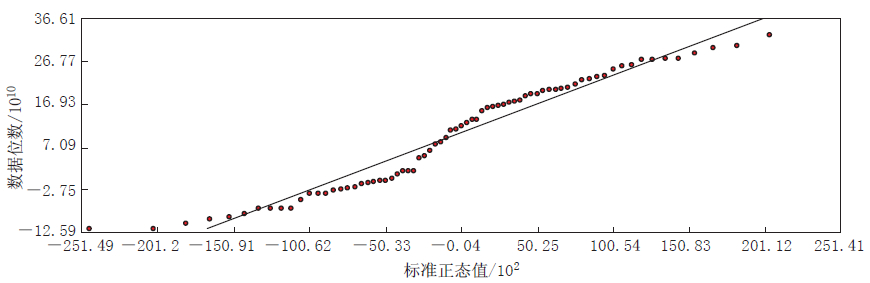
图 3 73个灾情短信点坡度的正态QQPlot分布
Figure 3. Normal QQPlot distribution of slope data at 73 earthquake SMS points
![]()
图 4 基于反距离权方法的汶川地震灾情插值结果
Figure 4. Interpolation result of Wenchuan earthquake disaster based on IDW method
![]()
图 5 基于径向基函数方法的汶川地震灾情插值结果
Figure 5. Interpolation result of Wenchuan earthquake disaster based on RBF method
![]()
图 6 基于普通克里金方法的汶川地震灾情插值结果
Figure 6. Interpolation result of Wenchuan earthquake disaster based on ordinary Kriging
![]()
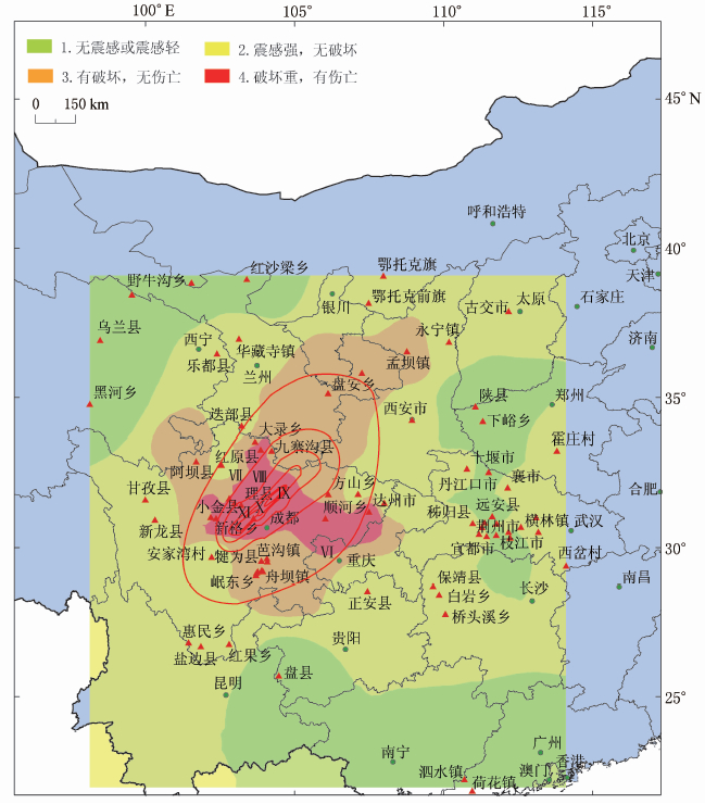
图 7 根据考虑坡度的协克里金方法得到的汶川地震灾情插值结果
Figure 7. Co-Kriging interpolation of Wenchuan earthquake disaster with topographic slope considered
表 3 汶川地震73个灾情短信点的不同插值方法交叉检验对比
Table 3 Cross-validation results of different interpolation methods for earthquake precipitation

 下载: 导出CSV
表 4 汶川地震73个灾情短信点的不同克里金插值方法交叉检验对比
Table 4 Cross-validation of different Kriging interpolation methods for earthquake precipitation
 下载: 导出CSV
-
薄景山, 李秀领, 李山有. 2003. 场地条件对地震动影响研究的若干进展[J]. 世界地震工程, 19(2): 11-15. 孟庆香, 刘国彬, 杨勤科. 2009. 黄土高原年均温的空间插值方法研究[J]. 干旱区资源与环境, 23(3): 83-87. 帅向华, 侯建盛, 刘钦. 2009. 基于地震现场离散点灾情报告的灾害空间分析模拟研究[J]. 地震地质, 31(2): 321-333. 汤国安, 杨昕. 2006. ArcGIS地理信息系统空间分析实验教程[M]. 北京: 科学出版社: 288-348. 吴学文, 晏路明. 2007. 普通Kriging法的参数设置及变异函数模型选择方法: 以福建省一月均温空间内插为例[J]. 地球信息科学, 9(3): 104-108. ESRI中国信息技术有限公司. 2010. ArcGIS desktop help[R/OL]. 北京: ESRI. [2011-09-06]. http://help.arcgis.com/zh-cn/arcgisdesktop/10.0/help/index.html#/na/003100000059000000/. -
期刊类型引用(0)
其他类型引用(1)


计量
- 文章访问数: 596
- HTML全文浏览量: 262
- PDF下载量: 16
- 被引次数: 1
