

Probabilistic seismic slope displacement hazard analysis based on Newmark displacement model:Take the area of Tianshui,Gansu Province,China as an example
-
摘要: 本文以天水地区为研究区,结合地震潜在震源区模型和Newmark位移预测方程,采用概率地震危险性分析方法,计算了该地区50年超越概率10%水平下的Newmark位移。同时,根据天水地区50年超越概率10%下的阿里亚斯烈度,并结合Newmark位移与阿里亚斯烈度的关系式,计算了天水地区在遭受50年超越概率10%下的阿里亚斯烈度影响时,潜在滑坡体产生的Newmark位移分布。通过比较上述两种方法得到的天水地区不同Newmark位移的分布特征,本文认为二者虽然存在较大差异,但其空间分布特征均能反映天水地区每个场点处的相对滑坡危险性。对滑坡危险性水平进行分区的结果显示,天水地区60%以上的区域具有高地震滑坡危险性,50%以上的区域具有甚高地震滑坡危险性。本文的研究结果可以作为天水地区地震危险性及风险评估的参考资料,也可以作为天水地区城市规划、土地使用规划、地震应急准备以及其它公共政策制定的参考资料。Abstract: Earthquake-induced landslide is a kind of destructive earthquake secondary disaster, which could cause serious casualties and property damage. The Tianshui area of Gansu Province has suffered severe landslides caused by several strong earthquakes. In this paper, based on the model of potential seismic sources and the prediction equation of Newmark displacement, we adopt the method of probabilistic seismic hazard analysis to study the probabilistic seismic landslide hazard in Tianshui area, and to calculate the values of Newmark displacement under the 10% probability of being exceeded in 50 years. Meanwhile, according to the Arias intensity under the 10% probability of being exceeded in 50 years in Tianshui area, combined with the relationship between Newmark displacement and Arias intensity, we also calculate the Newmark displacement of potential landslides when Tianshui area suffered from the Arias intensity under the 10% probability of being exceeded in 50 years. We compare the two sets of the values of Newmark displacement obtained by these two different methods, and find that there are significant difference, but still can reflect the relative landslide hazard of each site in Tianshui area. According to the results of landslide hazard zoning, more than 60% of the area in Tianshui has high earthquake-landslide hazard, and more than 50% of the region in Tianshui has very high earthquake-landslide hazard. The research results of this paper can be used as the reference materials of seismic hazard and risk assessment of Tianshui area, and can also be used as the reference materials of city planning, land use planning, earthquake emergency preparedness and other public policy making in Tianshui area.
-
-
![]()
图 1 Newmark位移滑块模型(引自Jibson et al,1998)
Figure 1. Sliding-block model of Newmark displacement (after Jibson et al,1998)
![]()
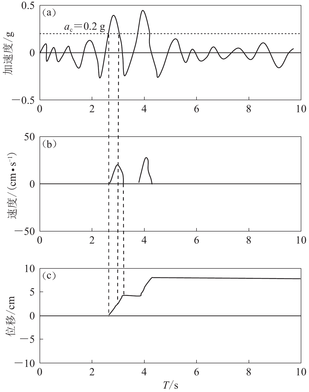
图 2 Newmark位移计算示意图(Wilson, Keefer,1983)
Figure 2. Demonstration of the Newmark-analysis algorithm (after Wilson,Keefer,1983)
![]()
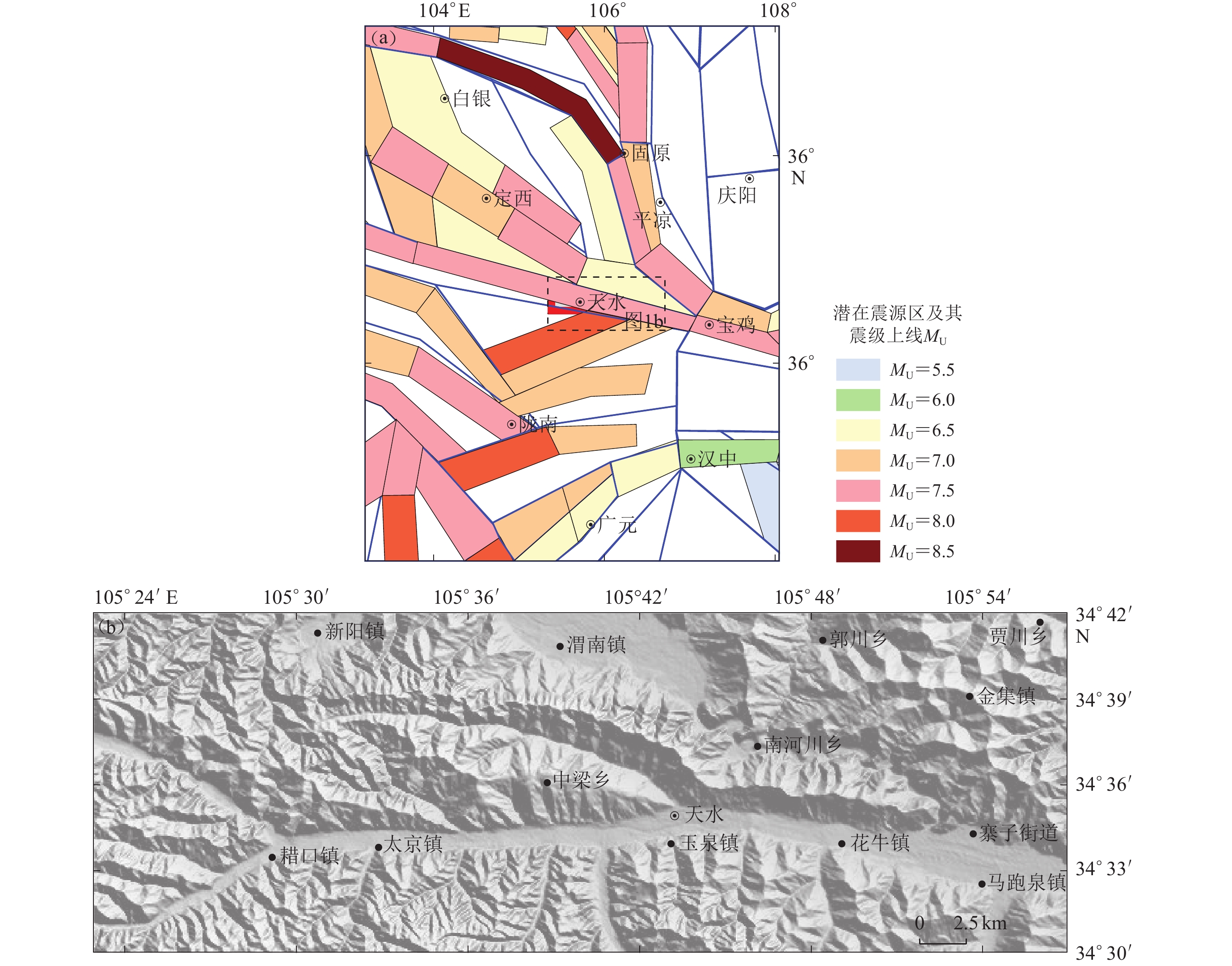
图 3 研究区周缘潜在震源区(a)及研究区具体范围(b)
Figure 3. Potential seismic sources around the Tianshui region (a) and the scope of the studied region (b)
![]()
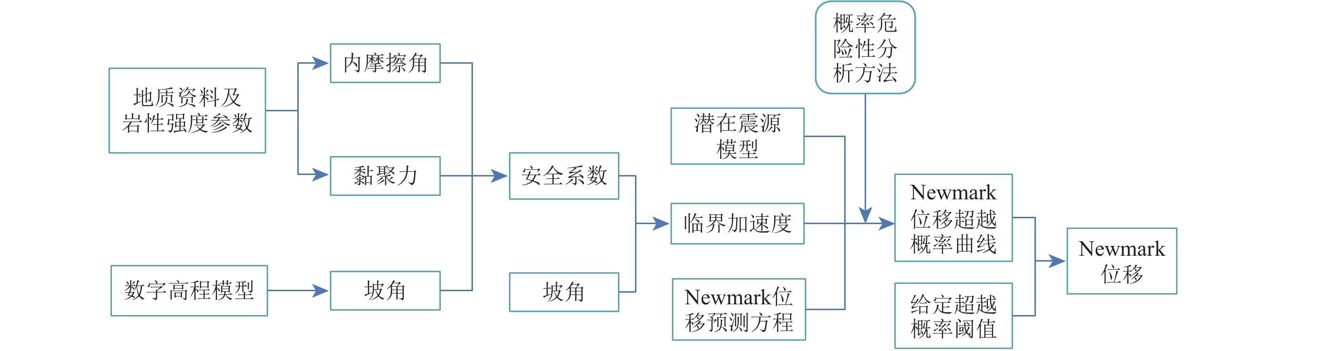
图 4 概率地震滑坡危险性分析计算流程图
Figure 4. Flow chart showing steps involved in producing a seismic landslide hazard map
![]()
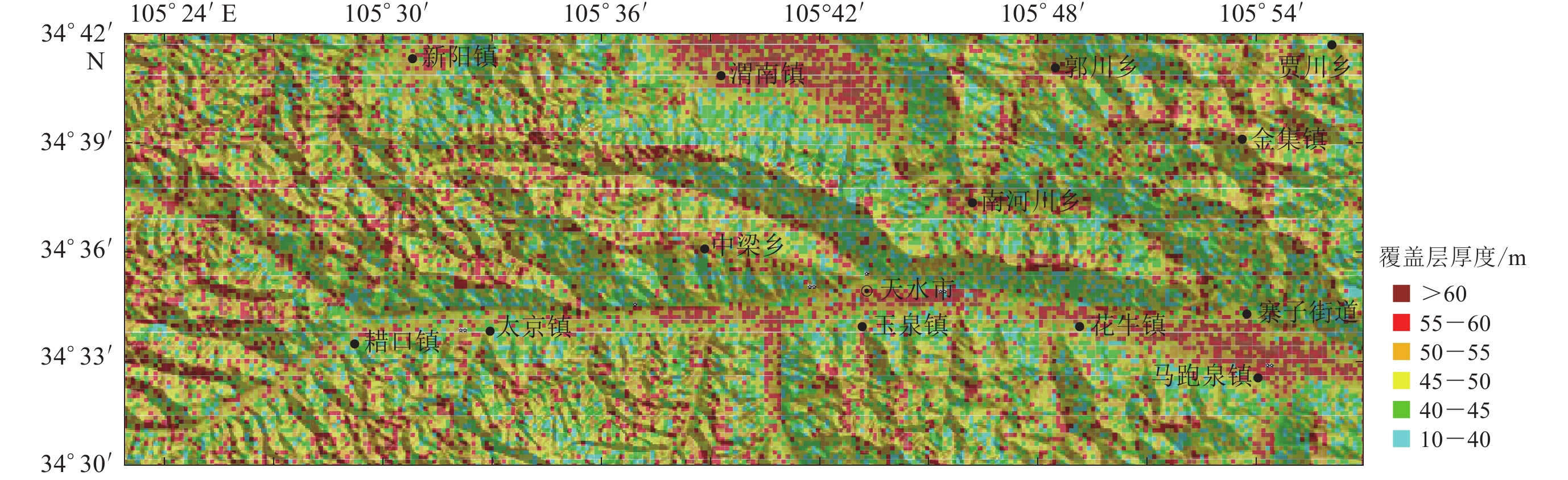
图 6 采用机器学习方法得到的覆盖层厚度分布图
Figure 6. Map showing the slab thickness obtained from machine learning method
![]()
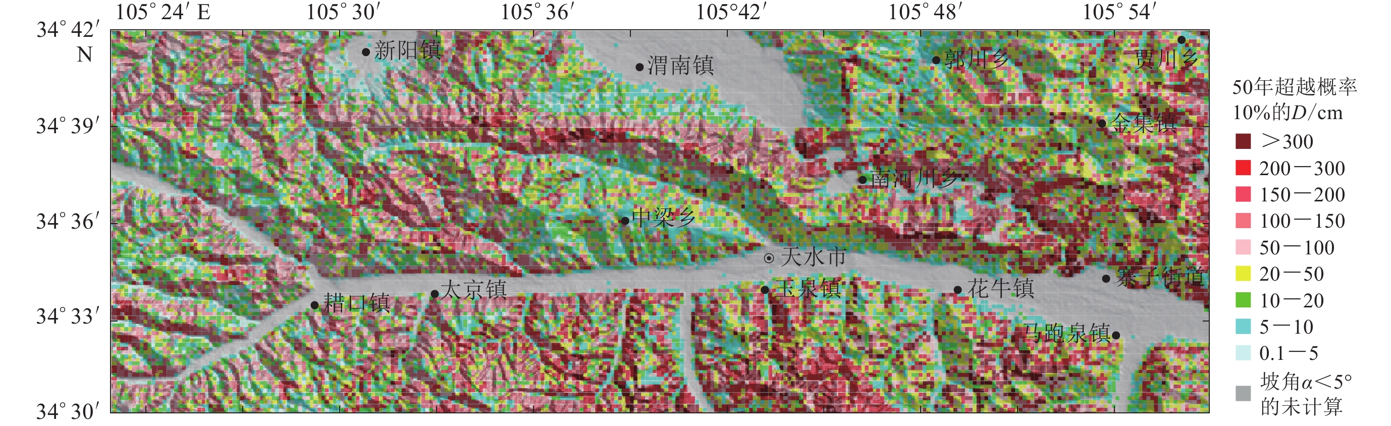
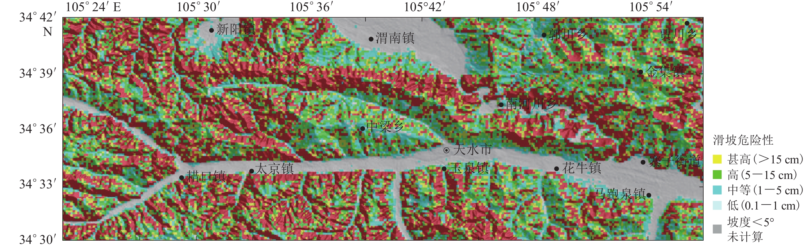
图 9 50年超越概率10%的Newmark位移D
Figure 9. Predicted Newmark displacements D with 10% probability of exceedance in 50 years
![]()
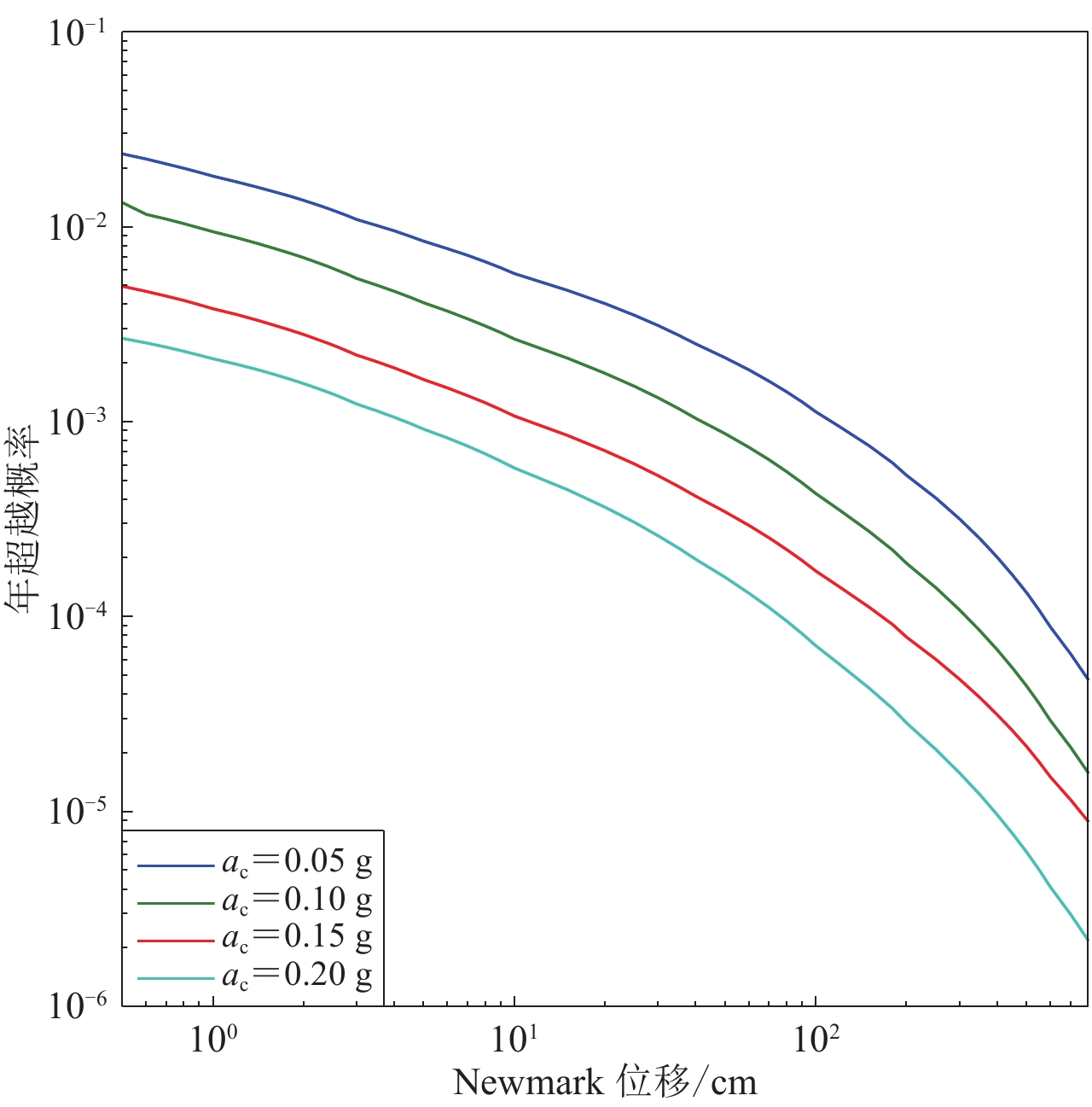
图 10 不同临界加速度ac下Newmark位移的超越概率曲线
Figure 10. Newmark displacement hazard curves under different critical accelerations
![]()
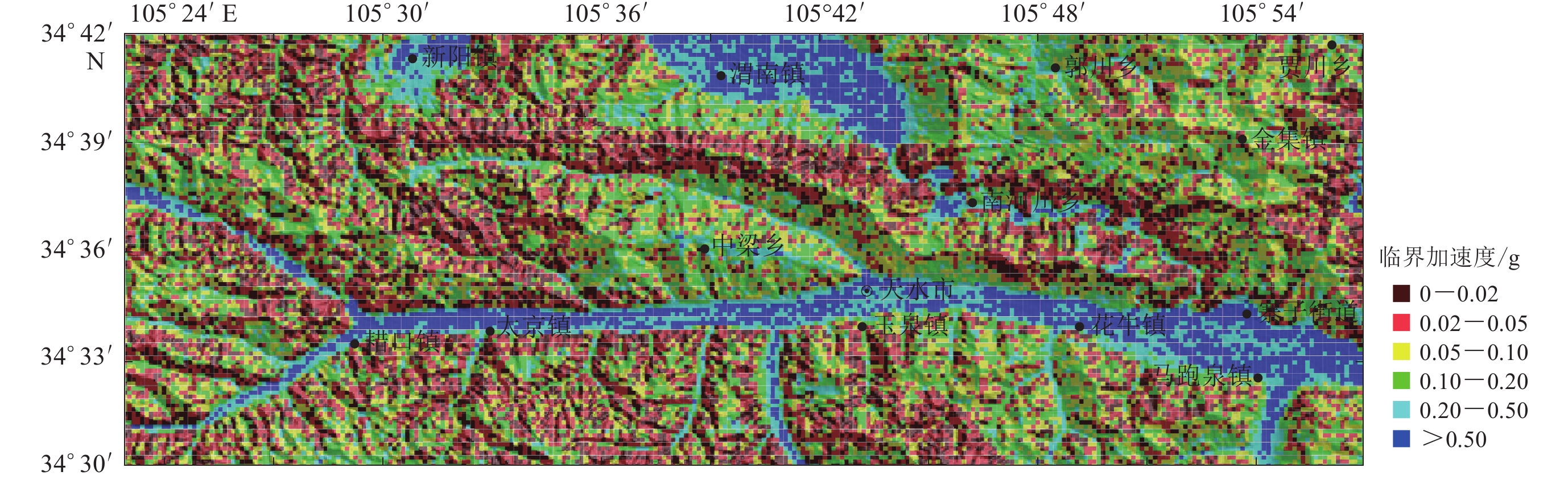
图 11 受到50年超越概率10%下的地震动(阿里亚斯烈度)影响时的Newmark位移
Figure 11. Newmark displacement hazard for shaking conditions related to 50-year exceedance probabilities of 10%
表 1 天水地区地质单元的剪切强度参数
Table 1 Shear strengths of geologic units in Tianshui
岩性 权重 c′ /kPa ϕ′ /° γ/(kN·m−3) 软岩(如泥岩等) 0.2 30 25 23.0 极软岩(如第四纪覆盖层) 0.8 24 21 15.4  下载: 导出CSV
表 2 Du和Wang (2016)计算的Newmark位移预测方程参数
Table 2 Coefficients of the Newmark displacement prediction equation proposed by Du and Wang (2016)
ac c1 c2 c3 c4 c5 c6 c7 h ν1 τ σ σt c8 c9 c10 c11 0.02 g 8.15 −0.14 −5.04 0.45 0.54 −2.25 − 6.32 −1.26 0.45 1.33 1.40 1.04 1.46 −1.71 −0.37 0.05 g 8.23 −0.18 −4.57 0.31 0.64 −4.84 0.31 5.72 −1.26 0.39 1.55 1.59 3.69 0.97 −1.74 −0.51 0.075 g 7.11 −0.08 −5.17 0.40 0.75 −3.21 0.09 4.19 −0.92 0.50 1.56 1.63 4.52 0.76 −1.76 −0.52 0.1 g 7.29 −0.14 −4.10 0.22 0.72 −4.67 0.38 4.23 −0.86 0.54 1.60 1.70 4.13 0.64 −1.78 −0.39 0.15 g 7.13 −0.21 −2.77 − 0.80 −1.35 − 4.55 −0.55 0.45 1.78 1.84 4.10 0.37 −1.51 −0.37 0.2 g 6.12 −0.25 −2.42 − 0.74 −1.65 − 5.53 −0.57 0.42 1.78 1.82 2.76 0.28 −1.27 −0.25 0.25 g 15.21 −0.27 −5.33 − 1.04 −0.72 − 14.30 −0.43 0.29 1.76 1.78 1.53 0.26 −1.14 −0.15
下载: 导出CSV
-
陈晓利,袁仁茂,庾露. 2013. Newmark方法在芦山地震诱发滑坡分布预测研究中的应用[J]. 地震地质,35(3):661–670. doi: 10.3969/j.issn.0253-4967.2013.03.019 Chen X L,Yuan R M,Yu L. 2013. Applying the Newmark’s model to the assessment of earthquake-triggered landslides during the Lushan earthquake[J]. Seismology and Geology,35(3):661–670 (in Chinese).
陈永明,石玉成,刘红玫,卢育霞. 2005. 黄土地区地震滑坡的分布特征及其影响因素分析[J]. 中国地震,21(2):235–243. doi: 10.3969/j.issn.1001-4683.2005.02.011 Chen Y M,Shi Y C,Liu H M,Lu Y X. 2005. Distribution characteristics and influencing factors analysis of seismic loess landslides[J]. Earthquake Research in China,21(2):235–243 (in Chinese).
高孟潭. 2015. GB18306—2015中国地震动参数区划图宣贯教材[M]. 北京: 中国质检出版社: 60−81. Gao M T. 2015. A Handbook of GB 18306−2015 Seismic Ground Motion Parameter Zonation Map of China[M]. Beijing: China Quality Inspection Publishing House: 60−81 (in Chinese).
刘百篪,周俊喜,李秦梅. 1984. 1718年通渭地震和1654年天水地震地区航空照片判读[J]. 地震科学研究,6(1):56–67. Liu B C,Zhou J X,Li Q M. 1984. Interpretation of air photographs of 1718 Tongwei earthquake and 1654 Tianshui earthquake[J]. Journal of Seismological Research,6(1):56–67 (in Chinese).
刘峰,张家声,黄雄南,牛向龙. 2009. 利用GIS方法研究南北地震带和中央造山带交汇区活动断裂与地震的关系[J]. 中国地震,25(4):394–404. doi: 10.3969/j.issn.1001-4683.2009.04.006 Liu F,Zhang J S,Huang X N,Niu X L. 2009. A GIS research on the relationship between active faults and earthquakes in China North-South Seismic Belt and central orogenic system intersection zone[J]. Earthquake Research in China,25(4):394–404 (in Chinese).
刘甲美. 2016. 概率地震滑坡危险性区划方法及应用[J]. 国际地震动态,(1):45–46. Liu J M. 2016. The method and application of probabilistic seismic hazard assessment for sliding displacement of slopes[J]. Recent Developments in World Seismology,(1):45–46 (in Chinese).
孙萍,殷跃平,吴树仁,汪发武,陈立伟. 2009. 高速远程地震黄土滑坡发生机制试验研究[J]. 工程地质学报,17(4):449–454. doi: 10.3969/j.issn.1004-9665.2009.04.003 Sun P,Yin Y P,Wu S R,Wang F W,Chen L W. 2009. An experimental study on the initiation mechanism of rapid and long run-out loess landslide caused by 1920 Haiyuan earthquake[J]. Journal of Engineering Geology,17(4):449–454 (in Chinese).
唐川,朱静,张翔瑞. 2001. GIS支持下的地震诱发滑坡危险区预测研究[J]. 地震研究,24(1):73–81. doi: 10.3969/j.issn.1000-0666.2001.01.012 Tang C,Zhu J,Zhang X R. 2001. GIS based earthquake triggered landslide hazard prediction[J]. Journal of Seismological Research,24(1):73–81 (in Chinese).
王家鼎,张倬元. 1999. 地震诱发高速黄土滑坡的机理研究[J]. 岩土工程学报,21(6):670–674. doi: 10.3321/j.issn:1000-4548.1999.06.008 Wang J D,Zhang Z Y. 1999. A study on the mechanism of high-speed loess landslide induced by earthquake[J]. Chinese Journal of Geotechnical Engineering,21(6):670–674 (in Chinese).
王涛,吴树仁,石菊松,辛鹏. 2013. 基于简化Newmark位移模型的区域地震滑坡危险性快速评估:以汶川MS8.0级地震为例[J]. 工程地质学报,21(1):16–24. doi: 10.3969/j.issn.1004-9665.2013.01.003 Wang T,Wu S R,Shi J S,Xin P. 2013. Case study on rapid assessment of regional seismic land-slide hazard based on simplified Newmark displacement model:Wenchuan MS8.0 earthquake[J]. Journal of Engineering Geology,21(1):16–24 (in Chinese).
张帅,孙萍,邵铁全,石菊松,孟静,胡秋韵,王涛. 2016. 甘肃天水黄土梁峁区强震诱发滑坡特征研究[J]. 工程地质学报,24(4):519–526. Zhang S,Sun P,Shao T Q,Shi J S,Meng J,Hu Q Y,Wang T. 2016. Earthquake-triggered landslides in Tianshui loess hilly region,Gansu Province,China[J]. Journal of Engineering Geology,24(4):519–526 (in Chinese).
周定一. 2010. 天水地区新近堆积黄土工程地质性质初探[J]. 甘肃科技,26(18):39–41. doi: 10.3969/j.issn.1000-0952.2010.18.015 Zhou D Y. 2010. Preliminary study on engineering geological properties of newly accumulated loess in Tianshui area[J]. Gansu Science and Technology,26(18):39–41 (in Chinese).
中华人民共和国住房和城乡建设部. 2015. 工程岩体分级标准(GB/T 50218—2014)[S]. 北京: 中国计划出版社: 12. Ministry of Housing and Urban-Rural Development of the People’s Republic of China. 2015. Standard for Engineering Classification of Rock Masses (GB/T 50218−2014)[S]. Beijing: China Planning Press: 12 (in Chinese).
Ambraseys N N,Menu J M. 1988. Earthquake-induced ground displacements[J]. Earthq Eng Struct Dyn,16(7):985–1006. doi: 10.1002/eqe.4290160704
Arias A. 1970. A measure of earthquake intensity[G]//Seismic Design for Nuclear Power Plants. Cambridge: Massachusetts Institute of Technology Press: 438−483.
Bray J D,Travasarou T. 2007. Simplified procedure for estimating earthquake-induced deviatoric slope displacements[J]. J Geotech Geoenviron Eng,133(4):381–392. doi: 10.1061/(ASCE)1090-0241(2007)133:4(381)
Del Gaudio V,Pierri P,Wasowski J. 2003. An approach to time-probabilistic evaluation of seismically induced landslide hazard[J]. Bull Seismol Soc Am,93(2):557–569. doi: 10.1785/0120020016
Du W, Wang G. 2013. Quantifying epistemic uncertainty and aleatory variability of Newmark displacements under scenario earthquakes[C]//Proceedings of the 4th International Symposium on Geotechnical Safety and Risk. Hong Kong: CRC Press: 28−31.
Du W Q,Wang G. 2016. A one-step Newmark displacement model for probabilistic seismic slope displacement hazard analysis[J]. Eng Geol,205:12–23. doi: 10.1016/j.enggeo.2016.02.011
Foulser-Piggott R,Stafford P J. 2012. A predictive model for Arias intensity at multiple sites and consideration of spatial correlations[J]. Earthq Eng Struct Dyn,41(3):431–451. doi: 10.1002/eqe.1137
Gülerce Z,Balal O. 2017. Probabilistic seismic hazard assessment for sliding displacement of slopes:An application in Turkey[J]. Bull Earthq Eng,15(7):2737–2760. doi: 10.1007/s10518-016-0079-1
Hsieh S Y,Lee C T. 2011. Empirical estimation of the Newmark displacement from the Arias intensity and critical acceleration[J]. Eng Geol,122(1/2):34–42.
Jarvis A, Reuter H I, Nelson A, Guevara E. 2008. Hole-filled seamless SRTM data V4, International Centre for Tropical Agriculture (CIAT)[EB/OL]. [2018−06−04].http://srtm.csi.cgiar.org.
Jibson R W. 1993. Predicting earthquake-induced landslide displacements using Newmark’s sliding block analysis[J]. Transp Res Rec,1411:9–17.
Jibson R W, Harp E L, Michael J A. 1998. A Method for Producing Digital Probabilistic Seismic Landslide Hazard Maps: An Example From the Los Angeles, California, Area[R]. Reston, Virginia: U.S. Geological Survey: 98−113.
Jibson R W,Harp E L,Michael J A. 2000. A method for producing digital probabilistic seismic landslide hazard maps[J]. Eng Geol,58(3/4):271–289.
Jibson R W. 2007. Regression models for estimating coseismic landslide displacement[J]. Eng Geol,91(2/4):209–218.
Jibson R W, Michael J A. 2009. Maps Showing Seismic Landslide Hazards in Anchorage, Alaska[R]. Reston, Virginia: U.S. Geological Survey: 8−11.
Jibson R W. 2011. Methods for assessing the stability of slopes during earthquakes:A retrospective[J]. Eng Geol,122(1/2):43–50.
Newmark N M. 1965. Effects of earthquakes on dams and embankments[J]. Géotechnique,15(2):139–160. doi: 10.1680/geot.1965.15.2.139
Rathje E M,Saygili G. 2008. Probabilistic seismic hazard analysis for the sliding displacement of slopes:Scalar and vector approaches[J]. J Geotech Geoenviron Eng,134(6):804–814. doi: 10.1061/(ASCE)1090-0241(2008)134:6(804)
Rathje E M,Saygili G. 2011. Estimating fully probabilistic seismic sliding displacements of slopes from a pseudoprobabilistic approach[J]. J Geotech Geoenviron Eng,137(3):208–217. doi: 10.1061/(ASCE)GT.1943-5606.0000431
Saygili G,Rathje E M. 2008. Empirical predictive models for earthquake-induced sliding displacements of slopes[J]. J Geotech Geoenviron Eng,134(6):790–803. doi: 10.1061/(ASCE)1090-0241(2008)134:6(790)
Saygili G,Rathje E M. 2009. Probabilistically based seismic landslide hazard maps:An application in southern California[J]. Eng Geol,109(3/4):183–194.
Travasarou T,Bray J D,Abrahamson N A. 2003. Empirical attenuation relationship for Arias intensity[J]. Earthq Eng Struct Dyn,32(7):1133–1155. doi: 10.1002/eqe.270
Urzúa A,Christian J T. 2013. Sliding displacements due to subduction-zone earthquakes[J]. Eng Geol,166:237–244. doi: 10.1016/j.enggeo.2013.08.005
Wilson R C,Keefer D K. 1983. Dynamic analysis of a slope failure from the 6 August 1979 Coyote Lake,California,earthquake[J]. Bull Seismol Soc Am,73(3):863–877.


计量
- 文章访问数: 2157
- HTML全文浏览量: 952
- PDF下载量: 84
