

Impact of topographic effect on ground motion characteristics in the extreme seismic region of Yangbi MS6.4 earthquake on May 21,2021
-
摘要:
基于对2021年5月21日漾濞MS6.4地震微观震中秀岭村进行的震害调查,利用流动观测地形台阵观测资料,分析了地形效应对地震动特性的影响。结果表明,若地震波垂直山脉走向入射,陡坡会放大地震波的高频部分,且不同高程处,山脉垂向低频差异较大,山脉走向低频差异较小。利用谱衰减法计算高频衰减参数的场地影响项κ0,分析了水平和竖向分量的κ0与场地软弱程度和卓越频率的相关性,其结果表明,在小尺度范围内,水平分量和竖向分量的κ0均具有较强的空间不均匀性。
Abstract:Historical earthquake experience has shown that complex terrain in mountainous areas can exacerbate earthquake damage. Complex terrain can alter the duration, amplitude and frequency characteristics of seismic waves, causing unanticipated and severe damage to buildings located on them. On May 21, 2021, a MS6.4 earthquake occurred in Yangbi, Yunnan Province. Near the epicenter of the earthquake, Xiuling village is located in a mountain range with a straight line distance of about 4.5 km from the top to the foot of the mountain, with an elevation difference of about 800 m. The investigation found that the damage to the houses on the top of the mountain was serious, generally manifested as wall collapse or serious damage; the damage to the houses on the mountainside was moderate, manifested as wall collapse and foundation settlement; the damage to the houses at the foot of the mountain was relatively light, without wall collapse, and was dominated by the tensile cracks in the contact surfaces of the structural columns and load-bearing walls. According to the difference in topographic seismic damage, four strong motion observation stations were set up at the top of the mountain, the mountainside and the foot of the mountain in Xiuling village, respectively, on June 8, and a reference station was set up in Huai’an village, which is located in a basin, with a total of five stations, and a total of 63 aftershocks with magnitudes ranging from 1.0 to 4.9 were recorded by the topographic mobile observation station array. According to the spatial distribution of mobile stations and aftershocks, the size of aftershocks and the mountain range orientation, three earthquakes with different magnitudes were selected for acceleration recording analysis, and the analysis results show that when the seismic waves are incident perpendicular to the mountain range orientation, there is anomalous amplification of the high frequency at the steep slopes of the mountainside, and the low-frequency portion of the Fourier amplitude spectrum at different elevations differs significantly along the mountain range orientation and the vertical orientation, at the same time the analysis results of the basin station under the three seismic effects also reflect the directional difference of the basin effect. A method is used to calculate the site effect term κ0 of the high-frequency attenuation parameters, and the correlation between the horizontal and vertical components of κ0 and the site softness and predominant frequency is analyzed, and the results show that, in the close range (<30 km), κH correlates with the softness of the local site conditions, which is determined by the predominant frequency and the peak amplification bandwidth of the site, and κV has a weaker correlation with local site softness, both of which have a decreasing trend with increasing local site predominant frequency, κV is especially obvious. Due to the relatively small number of observation stations, the relevant conclusions are only for the present study area. Considering the complexity of the actual mountainous terrain, more actual observational data are needed for validation. Through further verifying, it can provide a useful reference for the site adjustment estimated from ground motion impact on a small scale.
-
-
![]()
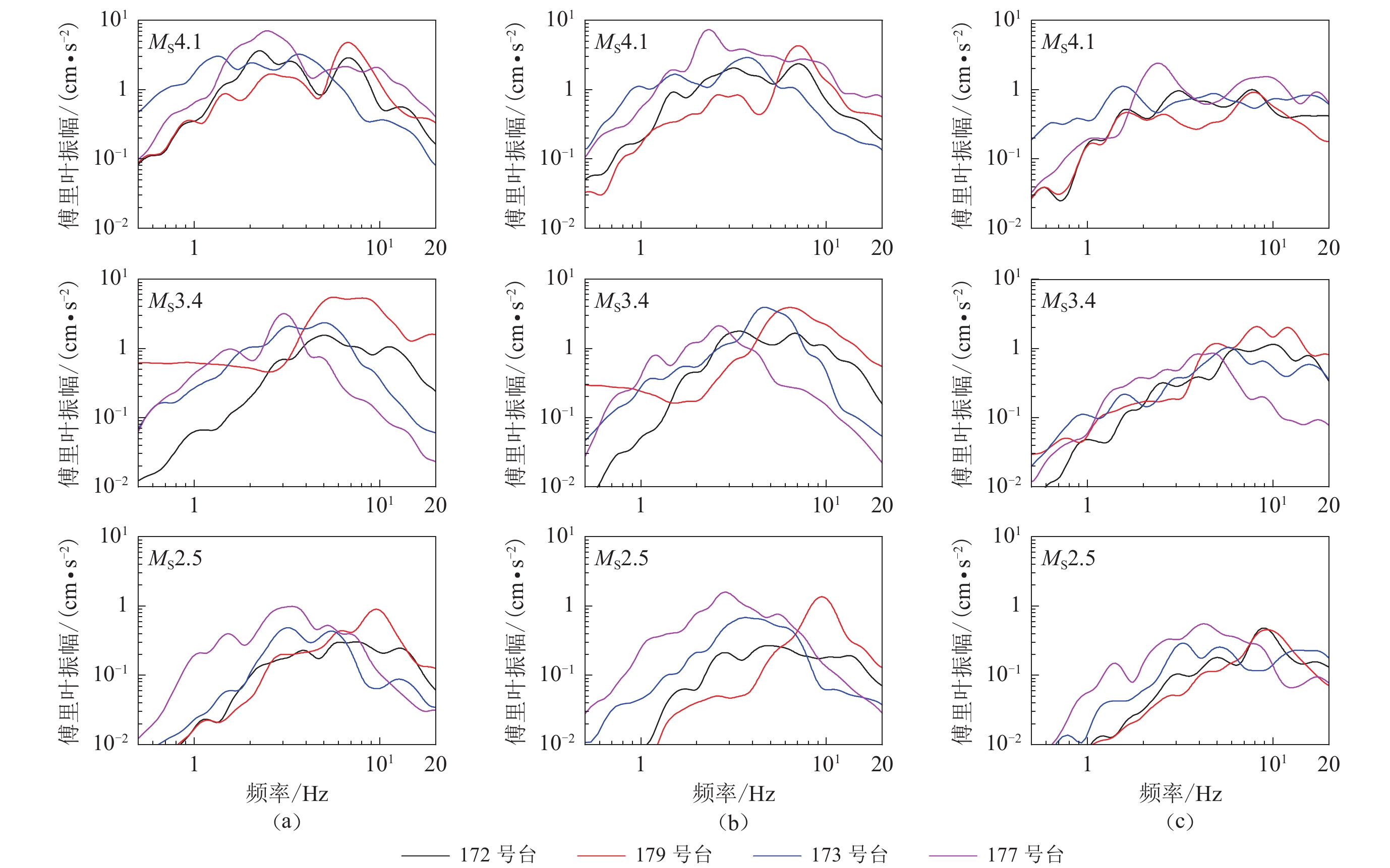
图 8 三次地震作用下流动台阵加速度平行山脉走向(a)、垂直山脉走向(b)和竖向(c)的傅里叶振幅谱
Figure 8. Fourier amplitude spectrum of mobile array acceleration parallel to the mountain range strike (a), perpendicular to the mountain range strike (b) and vertical (c) for three earthquakes
![]()
图 1 山顶、山腰和山脚位置处的地震破坏情况对比
(a) 山顶房屋东西向墙体倒塌;(b) 山顶房屋四面墙体倒塌;(c) 山腰房屋山墙倒塌;(d) 山腰房屋地基沉降;(e) 山脚房屋墙体拉裂
Figure 1. Comparison of seismic damage at top,mountainside and foot
(a) Collapse of the east-west wall of a house at the top of the mountain;(b) Collapse of all the walls of a house at the top of the mountain;(c) Collapse of the gable wall of a house on the mountainside;(d) Subsidence of the foundation on the mountainside;(e) Pull apart of the wall of a house at the foot of the mountain
![]()
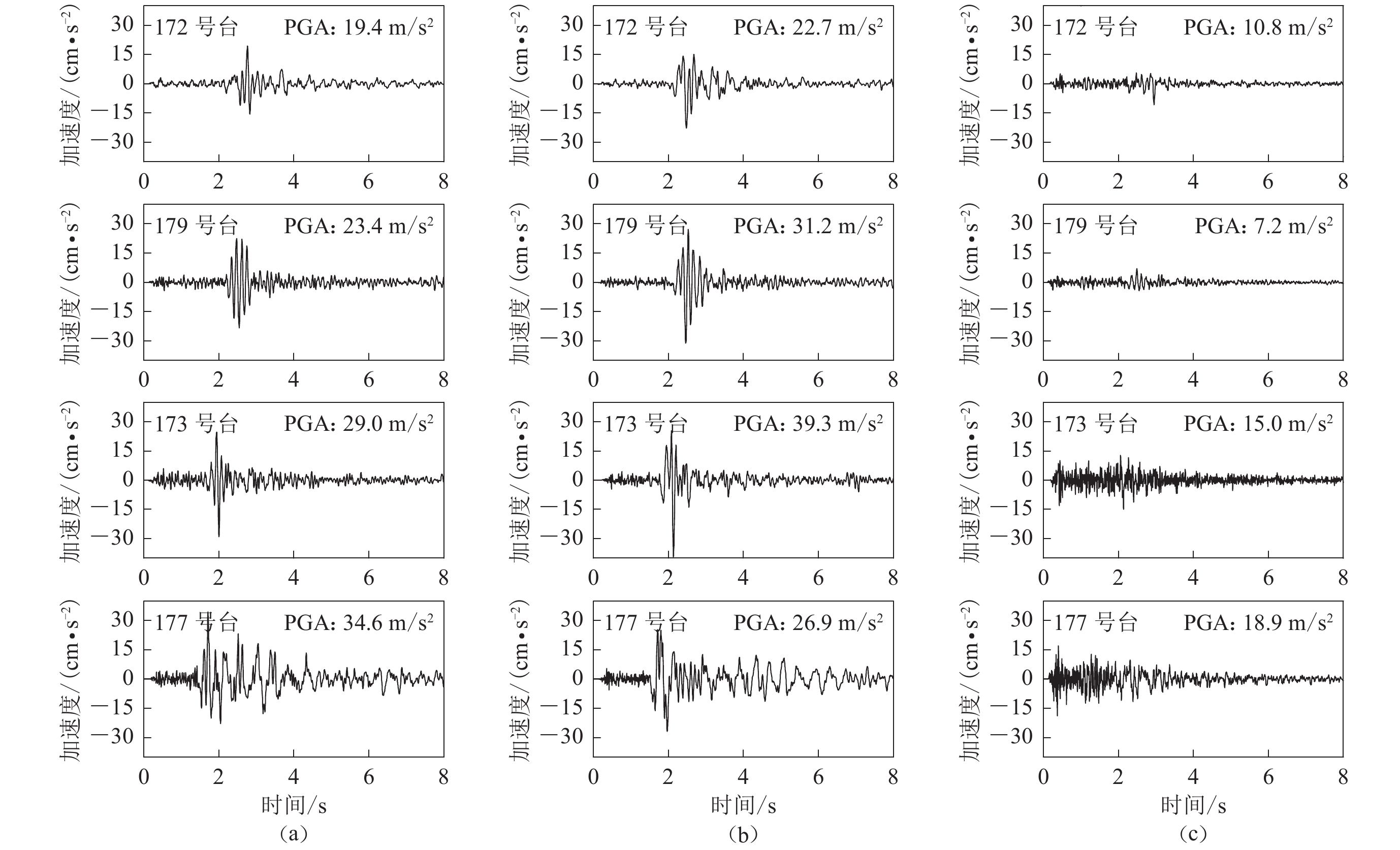
图 4 MS4.1地震作用下流动台阵的加速度东西向(a)、南北向(b)和竖向(c)时程
Figure 4. The acceleration time histories in east-west (a),north-south (b) and vertical (c) directions for the mobile array under the effect of the MS4.1 earthquake
![]()
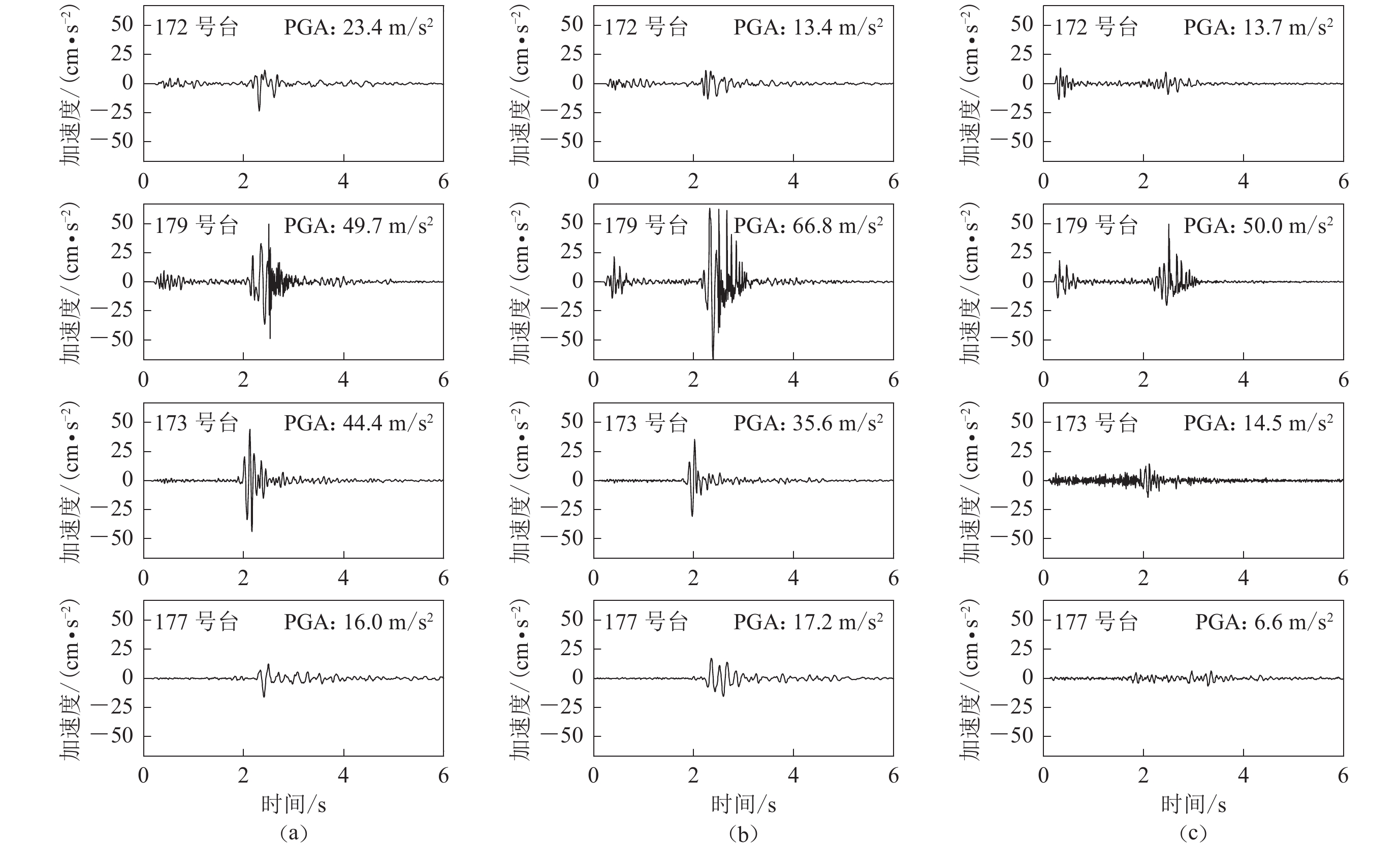
图 5 MS3.4地震作用下流动台阵的加速度东西向(a)、南北向(b)和竖向(c)时程
Figure 5. The acceleration time histories in east-west (a),north-south (b) and vertical (c) directions for the mobile array under the effect of the MS3.4 earthquake
![]()
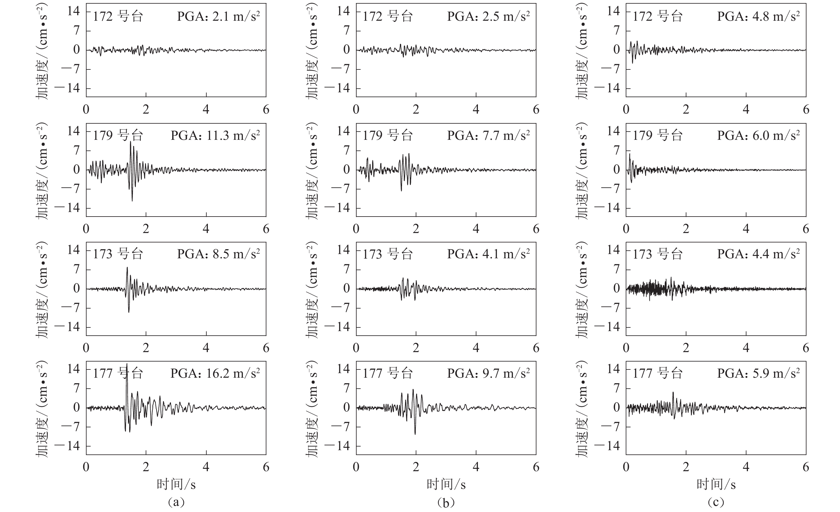
图 6 MS2.5地震作用下流动台阵的加速度东西向(a)、南北向(b)和竖向(c)时程
Figure 6. The acceleration time histories in east-west (a),north-south (b) and vertical (c) directions for the mobile array under the effect of the MS2.5 earthquake
![]()
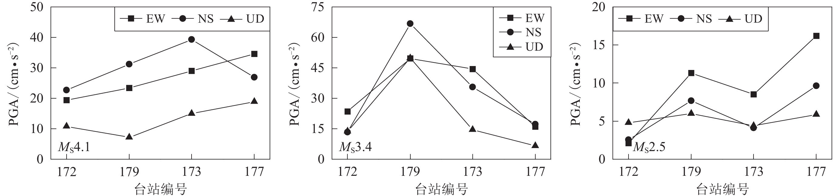
图 7 三次地震作用下不同台站(即不同高程) PGA 的变化规律
Figure 7. Variation of PGA at different stations (at different elevations) under the three earthquakes
![]()
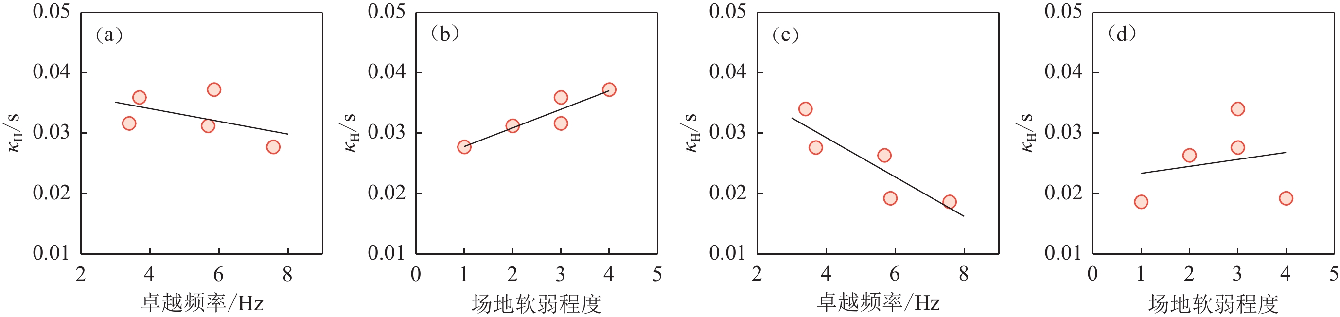
图 11 ${ {\textit{κ}} }_{\mathrm{H}}$ (a,b)和${ {\textit{κ}} }_{\mathrm{V}}$ (c,d)随场地卓越频率、场地软弱程度的变化规律
Figure 11. Changes in ${ {\textit{κ}} }_{\mathrm{H}}$ (a,b) and ${ {\textit{κ}} }_{\mathrm{V}}$ (c,d) with site predominant frequency and site weakness
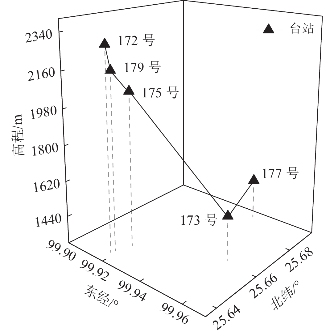
表 1 流动地形台阵台站信息
Table 1 Mobile terrain array station information
台站编号 场地类型 台站位置 高程/m 记录组数 台站编号 场地类型 台站位置 高程/m 记录组数 东经/° 北纬/° 东经/° 北纬/° 172 山顶台地 99.92 25.64 2 300 40 173 山脚缓坡 99.96 25.66 1 523 40 179 山腰陡坡 99.92 25.64 2 180 40 177 狭长盆地 99.94 25.69 1 505 39 175 山腰台地 99.92 25.65 2 070 8  下载: 导出CSV
表 2 流动地形台阵地震记录情况(2021年6月8日—7月11日)
Table 2 Seismic records of mobile terrain array (June 8−July 11,2021)
震级范围 地震次数 记录组数 震中距范围/km 1.0—1.9 31 63 0.9—13.2 2.0—2.9 29 92 0.9—16.4 3.0—3.9 2 8 2.2—8.5 4.0—4.9 1 4 5.8—24.9 总计 63 167 —
下载: 导出CSV
表 3 三次地震中四个台站对应的震中距
Table 3 Epicentral distance corresponding to four stations in three earthquakes
台站编号 MS4.1 MS3.4 MS2.5 172 16.8 14.2 11.8 179 16.6 14.2 11.8 173 13.8 13.0 12.9 177 12.0 15.7 12.5
下载: 导出CSV
表 4 五个流动台高频衰减参数信息
Table 4 High frequency attenuation parameter information of five mobile stations
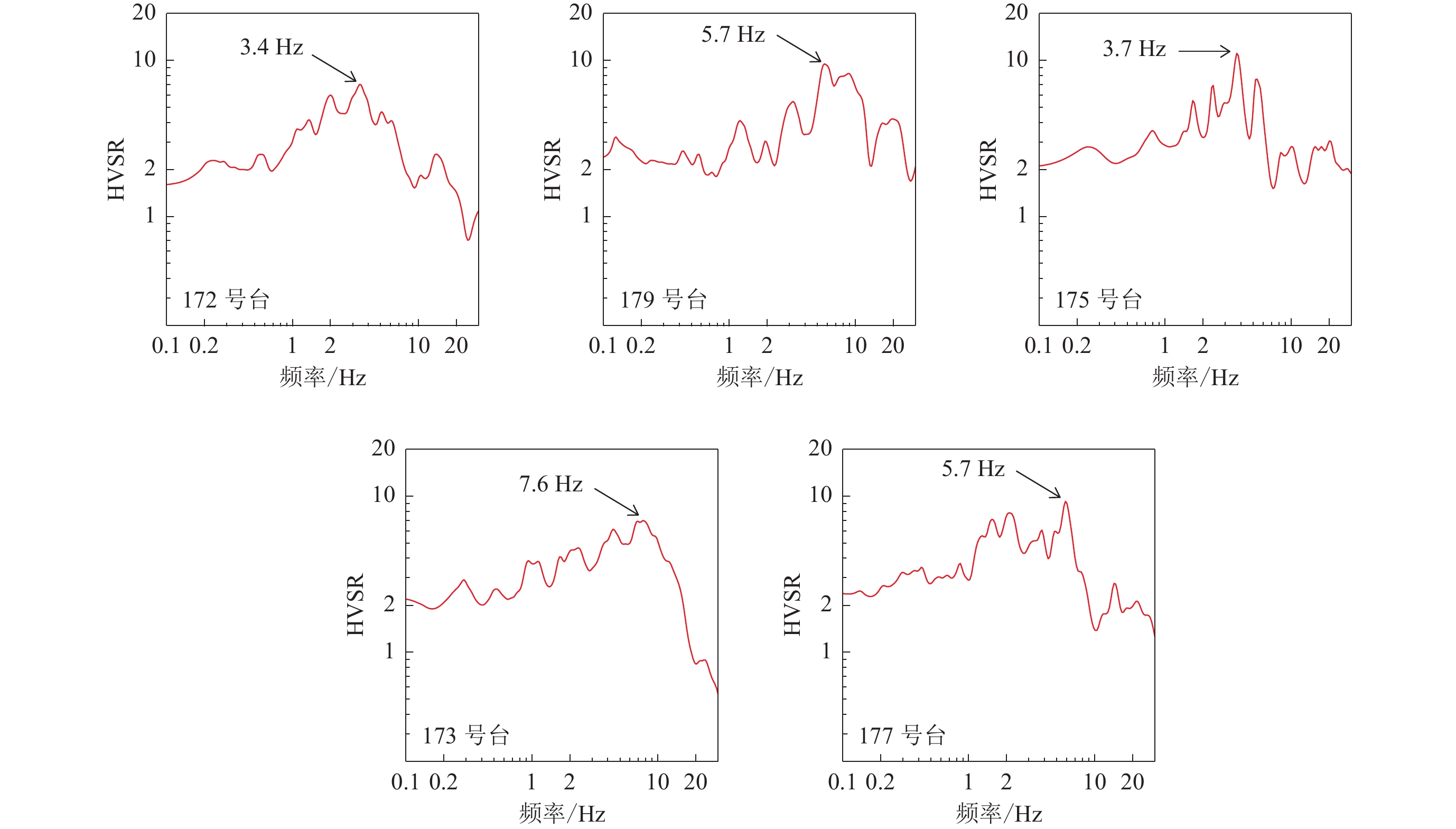
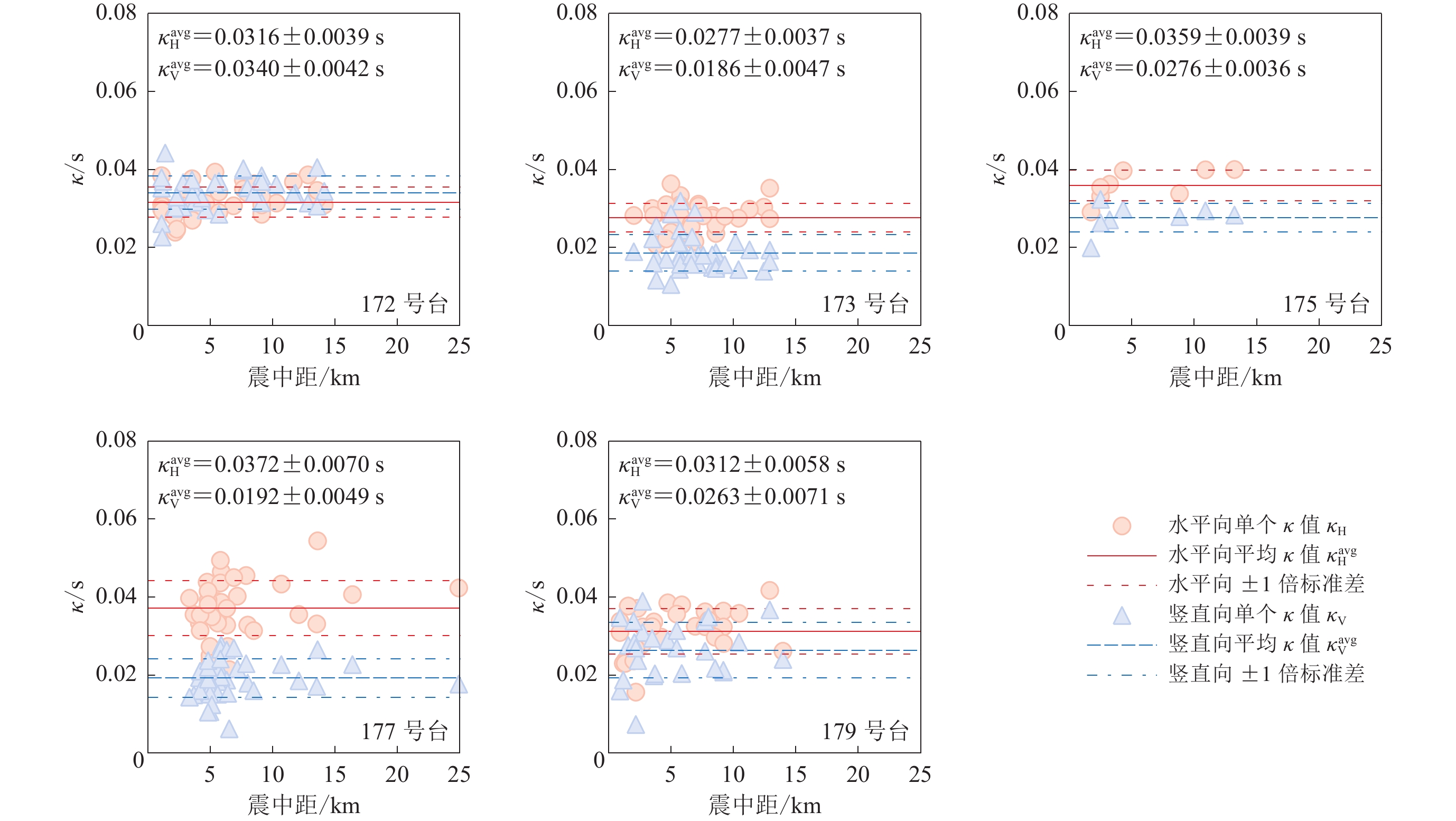
台站编号 软弱程度 fres/Hz ${ {\textit{κ}} }_{\mathrm{H} }$/s ${ {\textit{κ}} }_{\mathrm{V} }$/s 172 3 3.40 0.031 6 0.034 0 175 3 3.70 0.035 9 0.027 6 179 2 5.69 0.031 2 0.026 3 177 4 5.86 0.037 2 0.019 2 173 1 7.58 0.027 7 0.018 6 注:表中fres为场地卓越频率,${ {\textit{κ}} }_{\mathrm{H} } $为水平向场地项,${ {\textit{κ}} }_{\mathrm{V} } $为竖直向场地项
下载: 导出CSV
-
傅磊,李小军. 2017. 龙门山地区的Kappa ( κ0)模型及汶川 MS8.0地震的强地震动模拟[J]. 地球物理学报,60(8):2935–2947. doi: 10.6038/cjg20170803 Fu L,Li X J. 2017. The Kappa ( κ0) model of the Longmenshan region and its application to simulation of strong ground-motion by the Wenchuan MS8.0 earthquake[J]. Chinese Journal of Geophysics,60(8):2935–2947 (in Chinese).
李小军,荣棉水,喻烟. 2020. 场地土层模型参数的地震动记录反演方法[J]. 地球物理学报,63(1):236–246. doi: 10.6038/cjg2020M0491 Li X J,Rong M S,Yu Y. 2020. Inversion for velocity structure of soil layers by seismic acceleration records[J]. Chinese Journal of Geophysics,63(1):236–246 (in Chinese).
李渝生,黄润秋. 2009. 5·12汶川大地震损毁城镇的震害效应与重建选址问题[J]. 岩石力学与工程学报,28(7):1370–1376. Li Y S,Huang R Q. 2009. Earthquake damage effects of towns and reconstruction site selection in Wenchuan earthquake on May 12,2008[J]. Chinese Journal of Rock Mechanics and Engineering,28(7):1370–1376 (in Chinese).
林国良,张潜,崔建文,赵昆,杨黎薇. 2019. 利用地脉动HVSR研究2014年鲁甸6.5级地震场地效应[J]. 地震研究,42(4):531–537. doi: 10.3969/j.issn.1000-0666.2019.04.011 Lin G L,Zhang Q,Cui J W,Zhao K,Yang L W. 2019. Determining the site effects of the 2014 Ludian MS6.5 earthquake using HVSR microtremor method[J]. Journal of Seismological Research,42(4):531–537 (in Chinese).
荣棉水,李小军,王振明,吕悦军. 2016. HVSR方法用于地震作用下场地效应分析的适用性研究[J]. 地球物理学报,59(8):2878–2891. doi: 10.6038/cjg20160814 Rong M S,Li X J,Wang Z M,Lü Y J. 2016. Applicability of HVSR in analysis of site-effects caused by earthquakes[J]. Chinese Journal of Geophysics,59(8):2878–2891 (in Chinese).
孙崇绍,闵祥仪,周民都. 2011. 陇南山区局部地形对地震动强度的影响[J]. 西北地震学报,33(4):331–335. Sun C S,Min X Y,Zhou M D. 2011. Influence of local topography on ground motion in mountain region of southern Gansu Province[J]. Northwestern Seismological Journal,33(4):331–335 (in Chinese).
王伟. 2011. 地震动的山体地形效应[D]. 哈尔滨:中国地震工程力学研究所:1−191. Wang W. 2011. Effects of Hill Topography on Ground Motion[D]. Harbin:Institute of Engineering Mechanics,China Earthquake Administration:1−191 (in Chinese).
王伟,刘必灯,刘欣,杨明亮,周正华. 2015. 基于汶川 MS8.0地震强震动记录的山体地形效应分析[J]. 地震学报,37(3):452–462. doi: 10.11939/j.issn:0253-3782.2015.03.008 Wang W,Liu B D,Liu X,Yang M L,Zhou Z H. 2015. Analysis on the hill topography effect based on the strong ground motion records of Wenchuan MS8.0 earthquake[J]. Acta Seismologica Sinica,37(3):452–462 (in Chinese).
徐锡伟,闻学泽,郑荣章,马文涛,宋方敏,于贵华. 2003. 川滇地区活动块体最新构造变动样式及其动力来源[J]. 中国科学:D辑,33(增刊):151–162. Xu X W,Wen X Z,Zheng R Z,Ma W T,Song F M,Yu G H. 2003. Pattern of latest tectonic motion and its dynamics for active blocks in Sichuan-Yunnan region,China[J]. Science in China: Series D,46(S2):210–226. doi: 10.1360/03dz0017
周正华,张艳梅,孙平善,杨柏坡. 2003. 断层对震害影响的研究[J]. 自然灾害学报,12(4):20–24. doi: 10.3969/j.issn.1004-4574.2003.04.004 Zhou Z H,Zhang Y M,Sun P S,Yang B P. 2003. Study on effect of fault on seismic damage[J]. Journal of Natural Disasters,12(4):20–24 (in Chinese).
Anderson J G,Hough S E. 1984. A model for the shape of the Fourier amplitude spectrum of acceleration at high frequencies[J]. Bull Seismol Soc Am,74(5):1969–1993.
Anderson J G. 1991. A preliminary descriptive model for the distance dependence of the spectral decay parameter in southern California[J]. Bull Seismol Soc Am,81(6):2186–2193.
Bard P Y,Tucker B E. 1985. Underground and ridge site effects:A comparison of observation and theory[J]. Bull Seismol Soc Am,75(4):905–922. doi: 10.1785/BSSA0750040905
Boore D M. 1973. The effect of simple topography on seismic waves:Implications for the accelerations recorded at Pacoima Dam,San Fernando Valley,California[J]. Bull Seismol Soc Am,63(5):1603–1609. doi: 10.1785/BSSA0630051603
Davis L L,West L R. 1973. Observed effects of topography on ground motion[J]. Bull Seismol Soc Am,63(1):283–298. doi: 10.1785/BSSA0630010283
Douglas J,Gehl P,Bonilla L F,Scotti O,Regnier J,Duval A M,Bertrand E. 2009. Making the most of available site information for empirical ground-motion prediction[J]. Bull Seismol Soc Am,99(3):1502–1520. doi: 10.1785/0120080075
Douglas J,Gehl P,Bonilla L F,Gélis C. 2010. A κ model for mainland France[J]. Pure Appl Geophys,167(11):1303–1315. doi: 10.1007/s00024-010-0146-5
Houtte C V,Ktenidou O J,Larkin T,Holden C. 2014. Hard-site κ0 (Kappa) calculations for Christchurch,New Zealand,and comparison with local ground-motion prediction models[J]. Bull Seismol Soc Am,104(4):1899–1913. doi: 10.1785/0120130271
Ktenidou O J,Gélis C,Bonilla L F. 2013. A study on the variability of Kappa ( κ) in a borehole:Implications of the computation process[J]. Bull Seismol Soc Am,103(2A):1048–1068. doi: 10.1785/0120120093
Laurendeau A,Cotton F,Ktenidou O J,Bonilla L F,Hollender F. 2013. Rock and stiff-soil site amplification:Dependency on vS30 and Kappa ( κ0)[J]. Bull Seismol Soc Am,103(6):3131–3148. doi: 10.1785/0120130020
Lermo J,Chávez-García F J. 1993. Site effect evaluation using spectral ratios with only one station[J]. Bull Seismol Soc Am,83(5):1574–1594. doi: 10.1785/BSSA0830051574
Mena B,Mai P M,Olsen K B,Purvance M D,Brune J N. 2010. Hybrid broadband ground-motion simulation using scattering Green’s functions:Application to large-magnitude events[J]. Bull Seismol Soc Am,100(5A):2143–2162. doi: 10.1785/0120080318
Nakamura Y. 1989. A method for dynamic characteristics estimation of subsurface using microtremor on the ground surface[J]. Railw Tech Res Inst Quart Rep,30(1):25–33.
Spudich P,Hellweg M,Lee W H K. 1996. Directional topographic site response at Tarzana observed in aftershocks of the 1994 Northridge,California,Earthquake:Implications for mainshock motions[J]. Bull Seismol Soc Am,86(1B):S193–S208. doi: 10.1785/BSSA08601BS193
Wang M,Shen Z K. 2020. Present-day crustal deformation of continental China derived from GPS and its tectonic implications[J]. J Geophys Res: Solid Earth,125(2):e2019JB018774. doi: 10.1029/2019JB018774
Xu Y,Liu J H,Liu F T,Song H B,Hao T Y,Jiang W W. 2005. Crust and upper mantle structure of the Ailao Shan-Red river fault zone and adjacent regions[J]. Science China: Earth Science,48(2):156–164.


计量
- 文章访问数: 244
- HTML全文浏览量: 95
- PDF下载量: 82
