

Rupture process of the 2022 MS6.9 Menyuan,Qinghai earthquake revealed by inversion of regional broadband seismograms
-
摘要:
基于有限断层模型反演方法,利用区域宽频带数据反演了2022年1月青海门源MS6.9地震的震源破裂过程,并结合地质构造与地震重定位结果判断发震断层走向。综合反演结果表明:此次地震的发震断层走向为WNW向,主要以走滑为主;破裂主要发生在震源两侧,可能存在着双侧破裂,在震后2 s和9 s出现破裂极大值,最大错动量约为1.5 m,位于深度约6 km处,发生明显破裂的深度约为16 km,地表破裂长度约20 km;此次地震释放的标量地震矩为1.23×10¹⁹ N·m,相当于矩震级MW6.7,地震能量主要在前15 s释放;发震断层面的倾角为84.6°,接近于垂直,由于破裂范围较大,所以发生明显错动分布的地表投影也长达34 km。
Abstract:Finite fault inversion is an effective method commonly used to study the rupture process of earthquakes and has been widely applied to seismic source rupture process research. In this study, we utilized the method to investigate the rupture process of the MS6.9 Menyuan, Qinghai earthquake in 2022 using regional broadband seismic waveform data. Considering the quality and distribution of the network data, we selected 20 regional seismic stations with high signal-to-noise ratio and epicentral distances less than 500 km. We preprocessed the observed waveforms by removing instrument response, demeaning, detrending, and filtering. We also calculated the near-field Green’s functions using the frequency-wavenumber (f-k) method. First, synthesize the waveforms using the Green’s function synthesis theory and compare them with corresponding observed waveforms. Then, perform fault model inversion where the displacement response of each sub-fault at any station can be represented as a function of the sub-fault’s slip, direction, rise time, and rupture velocity. Additionally, in the process of reducing errors, we use wavelet transform to establish the objective function and use simulated annealing (SA) to search for the global optimal solution of each sub-fault parameter, so that the waveform residual can be minimized in the wavelet domain, ultimately obtaining the best spatio-temporal distribution model of the source fault slip. In this study, high frequency signal of regional network is used. Low-frequency information constrains the overall characteristics of the earthquake source, but is less sensitive to detailed rupture features such as rupture rise time or rupture velocity changes. However, sudden changes in slip amplitude or rupture velocity will radiate intense seismic signals with higher-frequency. Therefore, using higher-frequency signals for finite fault inversion can effectively improve spatial and temporal resolution, and fully utilize the wide-band information of seismic waves to better understand the earthquake source rupture process. The following results were obtained: ① The seismic fault is nodal planeⅠ(strike 104.2°, dip 84.6°, rake −5.4°). The rupture is mainly concentrated in two areas. The first area is a circular region with a radius of approximately 3 km above the hypocenter, with a maximum displacement of about 1.5 m, located at a depth of about 6 km underground, where the depth of obvious rupture is about 16 km. The earthquake caused a rupture to the surface with a maximum displacement of approximately 0.5 m, and the surface rupture length is about 20 km. Second, along the strike direction, the circular area with a radius of about 3 km is at the lower-right of the hypocenter, with a maximum displacement of approximately 1.2 m, at a depth of about 14 km. ② The scalar seismic moment released by the earthquake is 1.23×10¹⁹ N·m, corresponding to MW6.7. The earthquake rupture lasts about 17 s, with the maximum release of energy occurring around 8 s. The energy was mostly released before 15 seconds. ③ From the perspective of rupture direction, the rupture mainly propagates along the ESE direction. The maximum rupture values appear on both sides of the epicenter at 2 s and 9 s, reflecting the characteristics of bilateral rupture. According to the surface dislocation distribution map, the dip of the seismic fault surface is 84.6°, which is close to vertical. Therefore, the surface projection with obvious dislocation distribution is as long as 34 km. ④ Two obvious features can be identified: first, the fault plane has a large dip and releases a high amount of energy, resulting in significant surface ruptures with a length of approximately 18 km; second, there is bilateral rupture, accompanied with large displacements observed on both sides of the epicenter at 2 s and 9 s. The regional tectonic position also confirms that the initial rupture occurred along the Tuolaishan fault in an approximate E-W direction and triggered the NW-SE trending Lenglongling fault, which is closely related to the complex tectonic environment in the area.
-
引言
自新生代以来,印度板块持续北向推挤欧亚板块,造成青藏高原内部地壳缩短增厚,物质向周边逃逸(Tapponnier et al,1990)。青藏高原东北缘由于受到具有坚硬中上地壳的阿拉善地块的阻挡(钟世军等,2017),发育了地壳尺度的大型断裂带(图1),WNW向和NNW向的两组构造造就了青藏高原东北缘的构造格局。其中,祁连—海原断裂带由一系列左旋雁行活动断裂组成,含有轻微的由南向北的逆冲运动,是该区最重要的WNW向构造之一。托莱山断裂和冷龙岭断裂位于祁连—海原断裂带中段,右阶斜列,是断裂带的重要组成部分(陈文彬,2003),其中冷龙岭断裂以左旋走滑为主,向西发生斜滑(Gaudemer et al,1995)。青藏高原东北缘历史上发生过多次M7.0以上的地震,其中1920年以来发生过三次M7.5以上的大地震,即1920年海原M8½地震、1927年古浪M8地震和1932年昌马M7.6地震,这三次地震分别沿海原断裂、冷龙岭断裂和昌马断裂产生了显著的地震地表破裂带,并造成了重大人员伤亡(Zhang et al,1987;国家地震局地质研究所,宁夏回族自治区地震局,1990;Xu et al,2010;Guo et al,2019b,2020)。
![]() 图 1 青藏高原东北缘构造背景和2010—2022年ML≥3.0地震分布红色六角星为两次MS≥6.0地震的震中;沙滩球为MS≥5.0地震的震源机制解;右上角为研究区位置及地块运动方向示意图,图中红色箭头指示地块运动方向,黑色方框为研究区;左下角为 2022年1月门源MS6.9地震震中及周边(绿色方框)MS≥5.0地震的震源机制解,F1:肃南—祁连断裂,F2:托莱山断裂;F3:冷龙岭断裂Figure 1. Tectonic settings and distribution of ML≥3.0 earthquakes from 2010 to 2022 in the northeastern margin of Tibetan PlateauThe red stars are epicenters of two MS≥6.0 earthquakes,beach balls show focal mechanisms of the earthquakes with MS≥5.0. The upper-right inset gives the location of study area (black box) and the schematic illustration of block motion directions,where red arrows indicate the directions of block movements. The lower-left inset shows the epicenter of the January 2022 Menyuan MS6.9 earthquake and focal mechanism solutions of MS≥5.0 earthquakes in the surrounding region,F1:Su’nan-Qilian fault;F2:Tuolaishan fault;F3:Lenglongling fault
图 1 青藏高原东北缘构造背景和2010—2022年ML≥3.0地震分布红色六角星为两次MS≥6.0地震的震中;沙滩球为MS≥5.0地震的震源机制解;右上角为研究区位置及地块运动方向示意图,图中红色箭头指示地块运动方向,黑色方框为研究区;左下角为 2022年1月门源MS6.9地震震中及周边(绿色方框)MS≥5.0地震的震源机制解,F1:肃南—祁连断裂,F2:托莱山断裂;F3:冷龙岭断裂Figure 1. Tectonic settings and distribution of ML≥3.0 earthquakes from 2010 to 2022 in the northeastern margin of Tibetan PlateauThe red stars are epicenters of two MS≥6.0 earthquakes,beach balls show focal mechanisms of the earthquakes with MS≥5.0. The upper-right inset gives the location of study area (black box) and the schematic illustration of block motion directions,where red arrows indicate the directions of block movements. The lower-left inset shows the epicenter of the January 2022 Menyuan MS6.9 earthquake and focal mechanism solutions of MS≥5.0 earthquakes in the surrounding region,F1:Su’nan-Qilian fault;F2:Tuolaishan fault;F3:Lenglongling fault北京时间2022年1月8日1时45分27秒在青海省海北藏族自治州门源县发生MS6.9地震,根据中国地震台网(2022)的测定结果,震中位于(37.77°N,101.26°E)。震中附近的甘肃省河西五市震感强烈,截至2022年1 月17日6时,震源区共发生M0.0以上余震584次,其中M5.0—5.9地震1次,M4.0—4.9地震5次,M3.0—3.9地震19次,M2.0—2.9地震54次,M1.0—1.9地震248次,M0.0—0.9地震257次,最大余震为1月12日18时20分的MS5.3地震。该地区历史上也曾发生过M6.0以上地震,学者们也对该地区的地震活动进行了多学科研究。周琳等(2022)利用小震和全球定位系统(Global Positioning System,缩写为GPS)资料,结合该区域的构造应力场和应变率场分析了冷龙岭地区的地壳变形特征,并通过地震矩亏损推断该地区未来可能发生M7.2地震。冷龙岭断裂带位于青藏高原东北缘巨型弧形构造带的前缘地带,以左旋走滑为主,滑动速率约为4 mm/a (徐锡伟等,2017),局部兼具倾滑分量(Gaudemer et al,1995;何文贵等,2000,2010;Lasserre et al,2002)。震中附近的走滑断裂与逆冲断裂、主断裂和次级断裂组成了复杂的构造体系(Guo et al,2019a),即冷龙岭断裂、托莱山断裂、金强河断裂、毛毛山断裂、老虎山断裂、海原断裂等一起组成了祁连-海原断裂带(Zheng et al,2013)。研究该地震的发震构造以及如何进一步评估该区未来的强震活动趋势,成为震后及时研判的重要科学问题。
青藏地块在NE向构造应力作用(Tapponnier et al,2001;李祥等,2016;石富强等,2018)下发生了NE向的挤压缩短、顺时针旋转和向ESE方向的挤出构造变形(袁道阳等,2004),同时受到了阿拉善地块阻挡,导致地壳物质沿SE向挤出,形成了以左旋走滑及逆冲断裂系为主的构造体系,其最大主压应力轴呈现NE−ENE方向的变化(许英才等,2022)。冷龙岭断裂带作为祁连—海原断裂带的重要组成部分,尽管整体表现为左旋走滑运动,然而由于断层构造样式的复杂性,不同部位所表现出的运动特征也有所差异,其中最为显著的是1986年与2016年两次地震震源机制解的较大差异. 如图1左下角插图所示,虽然五次地震相距较近,但其震源机制结果差异较大:冷龙岭断裂北端与肃南—祁连断裂阶区处的三次地震主要以正断层为主;而肃南—祁连断裂及托莱山断裂与冷龙岭断裂的交会处的两次地震,主要以走滑断层为主,表明该地区地质构造的复杂性。
目前关于2022年1月门源MS6.9地震的发震构造还存在争议:为何相距不远的两次M5.0以上地震的机制解差异很大?它们之间有何关联?这一系列问题尚待进一步研究。而只有获取高精度的震源参数及震源破裂特征,才能够进一步分析该地区的地震活动特性,以及强震发生与发震构造带的相关性。此次门源MS6.9地震发生后,大量研究陆续展开。中国地震局地质研究所组织地震科考队伍对此次地震进行了现场考察,对该地区的区域地震构造背景、地表破裂带、发震构造、地震灾害及未来活动趋势研判等方面进行了分析(韩竹军等,2022)。基于远震波形数据得到的震源机制解,以及利用有限断层反演方法得到的震源破裂过程
1 (中国地震局地球物理研究所,2022)显示,最大破裂滑动量处于1.2 m与3.16 m之间,不确定性较大。由于路径和衰减效应等因素的影响,远场资料的分辨率不高,因此利用远震数据难以很好地约束地震的震源破裂过程。利用合成孔径雷达干涉测量(interferometric synthetic aperture radar,缩写为InSAR)及GPS数据并结合地震现场考察,对震后地表破裂及滑动分布的分析结果(李振洪等,2022;李智敏等,2022;潘家伟等,2022)表明,该手段主要依赖于地表破裂程度,对深部破裂过程的分辨率相对于波形反演较低。对于一次MW6.7地震,近震波形反演可以充分利用波形中的较高频信息,能够有效地提高反演结果的时空分辨率。因此,本文拟基于有限断层模型,利用区域宽频带波形数据反演2022年1月青海门源MS6.9地震的震源破裂过程,探讨此次地震发震断层的基本特征、震源破裂的时空迁移过程、断层面错动量、破裂方向和破裂尺度等,以期为进一步理解研究区地震的发震机理与地震活动特征以及开展地震灾害评估等工作提供地震学约束。1. 数据与方法
理解地震震源物理需要对震源运动学过程有完整的认识,而震源的运动学过程是通过有限断层两侧相对错动的时空分布来描述的(Ji et al,2002;朱音杰等,2022)。地震波携带着震源的运动学信息,因而可以通过地震波形记录来获取地震震源破裂过程的时空分布。对于M≥7.0强震,其地震波记录中低频(f<0.1 Hz)信号的能量相对较强,因此在震源反演中主要拟合的是较长周期的波形,而无法拟合高频信号(Ji et al,2002;Hsieh et al,2016)。低频信号仅能约束震源整体或较大尺度的特性,对较小尺度的破裂特性(如空间尺度较小的凹凸体或破裂随时间的快速变化)分辨力较差,而错动幅度或破裂速度在时空上的突然变化会辐射出较高频的地震信号(Aki,Richards,1980);此外,6.0≤M≤7.0强震辐射出的地震波能量也会向较高频率移动。因此,利用较高频率的波形信号进行有限断层反演可以有效地提高中强地震震源破裂过程的时空分辨率。
本研究以2022年1月门源MS6.9地震震源破裂过程为目标,使用中国地震科学数据中心提供的甘肃、青海、四川、内蒙、宁夏台网所记录的宽频波形数据,综合考虑研究区域内不同台网的数据质量和方位分布,采用信噪比高、震中距小于500 km的台站记录。由于门源地震震级较大,多个震中距较近的台站记录出现限幅而须舍弃,这样最终选取了20个台站。将这些台站的观测波形扣除仪器响应并对其去均值、去趋势,然后在0.01—0.2 Hz频带内进行带通滤波。另外,采用频率-波数法( f-k)计算近场格林函数,采样间隔为0.1 s。
2. 模型参数
有限断层反演方法在震源破裂过程研究中已经得到广泛应用(Ji et al,2002;Shao et al,2011;刘成利等,2013;Wei et al,2013;Hsieh et al,2016)。其原理是将整个断层面划分成若干个等面积子断层,通过设定的参考破裂速度和方向来计算每个子断层的破裂起始时间。本研究采用Ji等(2002)提出的震源破裂过程反演方法,该方法将每一子断层视为点源,计算该点源在某一台站所产生的位移,将所有子断层点源的位移叠加起来,便得到整个有限断层破裂在该台站的理论地震图:
$$ {{{u}}} ( {{{t}}} ) =\sum\limits _{{{{j}}}=1}^{{{{{N}}}}_{{{{j}}}}}\sum\limits _{{{{i}}}=1}^{{{{{N}}}}_{{{{i}}}}}{{{{d}}}}_{{{{i}}}{{{j}}}}[{{{{\rm{cos}}}}}{{ \lambda }}_{{{{i}}}{{{j}}}}{{{{G}}}}_{{{{i}}}{{{j}}}}^{1} ( {{{{v}}}}_{{{{i}}}{{{j}}}}, {{{t}}} ) + {{{{\rm{sin}}}}}{{\lambda }}_{{{ij}}} {\text{×}} {{{{G}}}}_{{{ij}}}^{2} ( {{{{v}}}}_{{{ij}}}, {{{t}}} ) ]{*}{{{{S}}}}_{{{ij}}} ( {{{t}}} ) ,$$ (1) 式中:u(t)为台站的位移响应;下角标ij为子断层序号,表示沿走向第i个、沿倾向第j个子断层;Ni和Nj分别为沿断层走向和倾向的子断层数目;dij和λij分别为子断层ij的错动量和错动角;$ {G}_{ij}^{1} ( {v}_{ij}, t ) $和$ {G}_{ij}^{2} ( {v}_{ij}, t ) $分别为该子断层沿走向和倾向错动的格林函数;vij是由该子断层错动起始时间及其与震源位置之间的距离所定义的子断层破裂传播速度;Sij(t)为该子断层错动时间函数,可以由不同的上升时间$ {\tau }_{ij}^{1} $和下降时间$ {\tau }_{ij}^{2} $两个参数来定义的非对称时间函数(Ji et al,2003)。Ji等(2002)的非线性反演方法的基本思想是随机给定每个子断层上的五个震源参数,包括dij,λij,vij,$ {\tau }_{ij}^{1} $和$ {\tau }_{ij}^{2} $,通过式(1)合成理论波形,并计算其与观测波形之间的残差,然后利用模拟退火法提高其在模型空间采样的效率,最终找到使波形残差极小的所有子断层震源参数的最佳组合,此即为有限断层震源破裂过程的时空分布模型。
在断层面的选取上,我们采用王卫民等
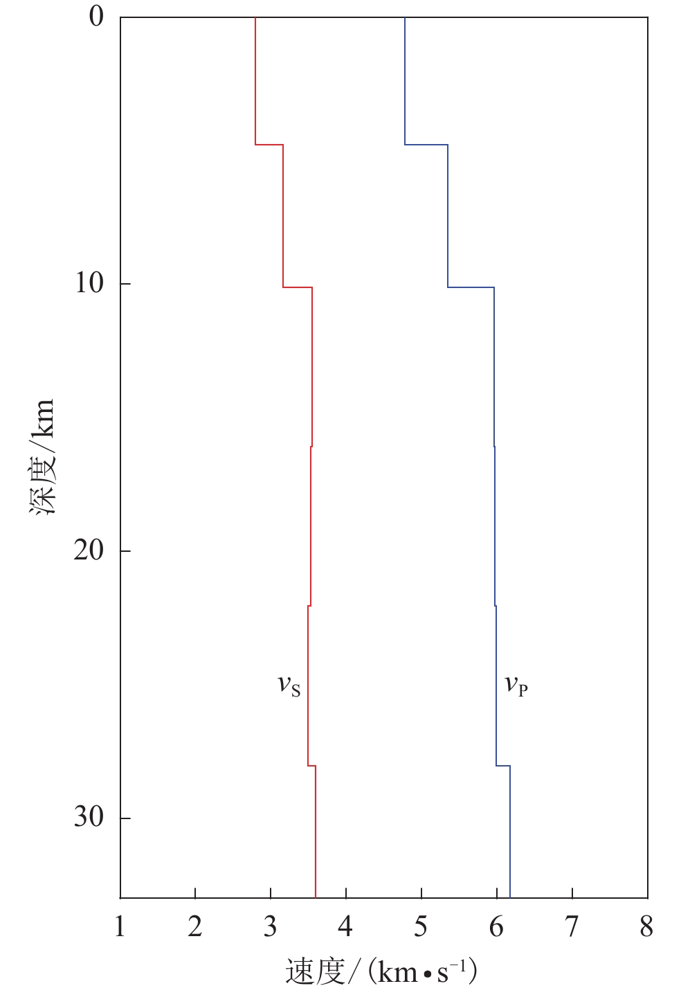
1 利用信噪比较高且方位角分布均匀的18个远场P波波形(震中距位于30°—90°范围之内)和24个SH波波形资料反演所得到的点源震源机制解结果,其中:节面I的走向、倾角和滑动角分别为104.2°,84.6°和−5.4°;节面Ⅱ的走向、倾角和滑动角分别为194.2°,89.9°和−174.6°。在正演中,使用频率-波数法(Zhu,Rivera,2002)计算格林函数。为减小地壳速度模型所带来的误差,采用震中距为500 km以内的台站,并在格林函数计算中使用基于中国大陆岩石圈三维模型USTClitho2.0 (Han et al,2022)在震中附近得到的一维速度模型(图2)。![]() 图 2 本研究中用来反演震源机制解及破裂过程的地壳分层速度模型Figure 2. Layered crustal velocity model used in the inversions of focal mechanism solution and rupture process in this study
图 2 本研究中用来反演震源机制解及破裂过程的地壳分层速度模型Figure 2. Layered crustal velocity model used in the inversions of focal mechanism solution and rupture process in this study考虑到点源震源机制解中的两个节面均有可能但仅有一个是实际的发震断层面,我们分别以震源机制解的两个节面为断层面来反演门源地震的震源破裂模型。根据门源地震的震级MS6.9,设定断层面沿走向和倾向的整体尺度分别为38 km和18 km。对于节面 Ⅰ ,断层走向和倾角分别为104.2°和84.6°,断层面沿走向和倾向以19×9的网格划分为2.0 km×2.0 km的子断层。反演中每个子断层的错动量搜索范围为0.1—2.0 m,步长为0.01 m;错动角搜索范围参考震源机制解节面 Ⅰ 的滑动角−5.4°设置为−5°±30°,间隔为2°;破裂速度的搜索范围为1.0—3.0 km/s,间隔为0.1 km/s;上升与下降时间的搜索范围均为0.2—4.0 s,间隔为0.2 s。对于节面 Ⅱ ,断层走向和倾角分别为194.2°和89.9°,子断层错动角的范围参考震源机制解节面Ⅱ 的滑动角−174.6°设置为−175°±30°,间隔为2°,其余参数设置均与节面 Ⅰ 相同。通常对于震级较大的地震(MW>7.5),由于破裂分布范围较大,观测数据也较为丰富,两个节面反演得到的波形拟合效果会有明显差别,残差较小的节面便是实际的发震面。但是,对于中等地震,破裂分布范围会比使用的地震波波长小很多,此时根据波形残差难以判断实际的发震面。
3. 反演结果
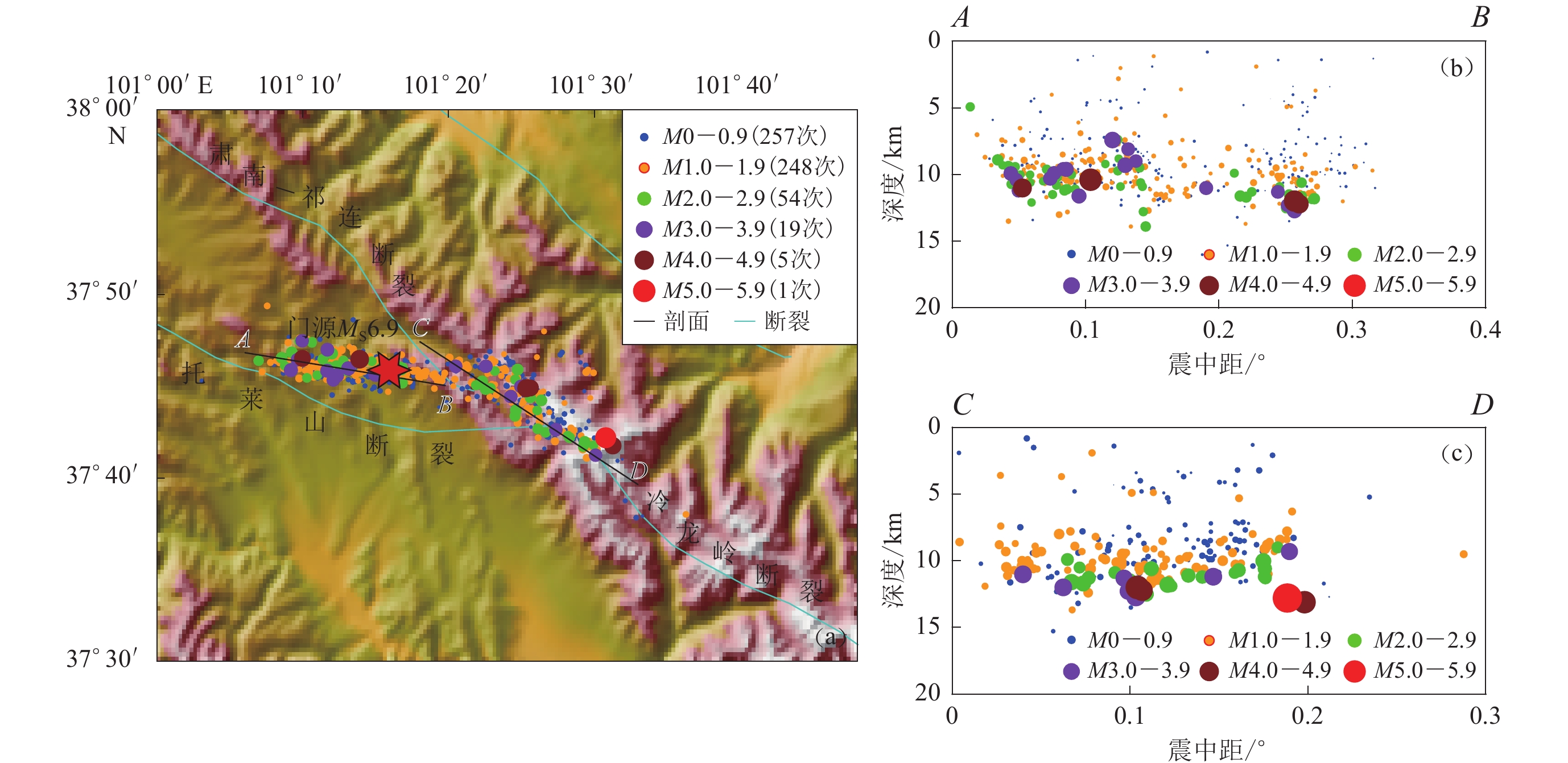
震源破裂过程反演中需要给定破裂的起始位置,通常以已知的震中位置及相应的震源深度为参考。本研究参考门源地震精定位的结果(潘家伟等,2022;许英才等,2022),采用震中位置(37.77°N,101.27°E),初始破裂深度为7.8 km。图3显示了门源地震余震精定位结 果,截止到2022年1月17日6时,共计584次M>0地震。通过重定位的余震水平面分布及深度剖面图可见,余震分布主要分为东西两段:西段位于托莱山断裂,从祁连—肃南断裂南段到托莱山断裂阶区,优势长轴长约15 km,呈WNW展布,初始破裂深度主要集中在7—13 km;东段沿冷龙岭断裂展布,包括冷龙岭断裂与托莱山、肃南—祁连断裂的交会地带,优势长度约为25 km,呈NW展布,初始破裂深度主要集中于7—14 km。余震序列存在显著的迁移现象(范莉苹等,2022),且主震与1月12日的M5.3余震分别位于两个余震分布带上,因而存在着主震为双侧破裂的可能性。
![]() 图 3 2022年1月门源MS6.9地震的余震分布(a) 地表投影;(b) 在AB剖面上的投影;(c) 在CD剖面上的投影Figure 3. Distribution of the aftershocks of the January 2022 Menyuan MS6.9 earthquake(a) Projection of aftershocks on the surface;(b) Projection of aftershocks on the cross section AB; (c) Projection of aftershocks on the cross section CD
图 3 2022年1月门源MS6.9地震的余震分布(a) 地表投影;(b) 在AB剖面上的投影;(c) 在CD剖面上的投影Figure 3. Distribution of the aftershocks of the January 2022 Menyuan MS6.9 earthquake(a) Projection of aftershocks on the surface;(b) Projection of aftershocks on the cross section AB; (c) Projection of aftershocks on the cross section CD从门源地区2013年以来发生的M>5.0地震震源机制解(图1左下插图)来看,五次地震之间相距不足40 km,但呈现了两组完全不同的震源机制。西段的两次地震以左旋走滑为主,而东段的三次地震以逆冲型为主,表现出该地区地质构造特征的复杂性。1986年和2016年在冷龙岭北侧先后发生两次MS6.4地震,但其震源机制解与冷龙岭断裂的走滑型特征有所差异(周琳等,2022)。此次门源地震震源位于托莱山断裂与祁连—肃南断裂阶区,而目前大多数研究结果均认为此次地震的发震断层与冷龙岭断裂有关(李振洪等,2022;许英才等,2022)。冷龙岭断裂整体沿WNW方向延伸,门源地震的震源机制与此断层性质也吻合。然而中国地震局地质研究所(2022)的现场调查初步结果显示,此次地震的发震构造既不是冷龙岭断裂,也不是托莱山断裂,而是发育在两断裂之间阶区中的道沟断裂。沿该断裂存在很好的断错地貌现象,形成了冷龙岭断裂与托莱山断裂之间的阶区中复杂断裂系统的一部分。范莉苹等(2022)根据余震序列精定位结果和断裂地表迹线推断,此次门源地震发生在冷龙岭断裂与托莱山断裂交会的部位,西段的余震活动与托莱山断裂有关,而东段与冷龙岭断裂有关。但目前有关托莱山断裂的研究还较少,若该断裂并非以较小角度北倾,则此次门源地震就可能发生在托莱山断裂北侧的一条未知断层上。至于究竟点源震源机制解的两个节面中哪一个是实际的发震断层面,如前所述,对于门源地震这种中等规模的地震,两个节面反演结果的波形残差相差不大,不易据此来确定哪个节面是实际的发震面。因此我们综合地质构造、震源机制解和余震展布,初步认为2022年1月8日门源MS6.9地震震源机制解中WNW走向的节面(即节面Ⅰ)为该地震破裂面,其破裂方式为左旋走滑。
图4给出了以节面Ⅰ为断层面反演所得结果所对应的波形拟合及台站分布,可以看到,台站空间分布较好,完全包围了震中。在震源破裂过程反演中,采用近场台站,利用相对较高频率的波形时,破裂的方向性效应对波形的影响就会显现(刘成利等,2014)。所以,在波形拟合方面,通过权重设置对拟合程度不同的波形适当加以取舍,能够减小其它因素如速度结构的横向变化、地形起伏以及偶尔的仪器故障等所产生的影响。
![]() 图 4 门源地震震中位置及周边台站分布图(a)和以节面 Ⅰ 为断层面反演的波形拟合(b)黑色与红色波形分别为观测波形与理论波形;每组波形上面给出了台站名称,从上至下分别为东西、南北、垂直三个分量,波形上的数字为最大振幅,单位为cmFigure 4. The epicenter of Menyuan earthquake and distribution of surrounding stations (a) and waveform fitting when using nodal plane Ⅰ as the fault plane in slip distribution inversion (b)Black and red traces are observed and synthetic waveforms,respectively. On the set of waveforms are the code of the station,and the waveforms are EW,SN and UD components from up to down. The number above each trace indicates the maximum amplitude of the data in unit of cm
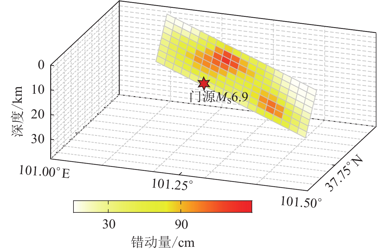
图 4 门源地震震中位置及周边台站分布图(a)和以节面 Ⅰ 为断层面反演的波形拟合(b)黑色与红色波形分别为观测波形与理论波形;每组波形上面给出了台站名称,从上至下分别为东西、南北、垂直三个分量,波形上的数字为最大振幅,单位为cmFigure 4. The epicenter of Menyuan earthquake and distribution of surrounding stations (a) and waveform fitting when using nodal plane Ⅰ as the fault plane in slip distribution inversion (b)Black and red traces are observed and synthetic waveforms,respectively. On the set of waveforms are the code of the station,and the waveforms are EW,SN and UD components from up to down. The number above each trace indicates the maximum amplitude of the data in unit of cm图5显示了以节面Ⅰ为断层面反演得到的1月8日门源MS6.9地震震源破裂的空间与时间分布。从图5a可以看出,断层破裂主要集中在两个部分:一是震源正上方的一个半径约3 km的圆形区域,最大错动量约为1.5 m,位于深度约6 km处,破裂延伸至约16 km深度,地震活动破裂到地表,最大错动量约为0.5 m,地表破裂长度约为20 km;二是沿走向方向,在震源右下方的一个半径约3 km的圆形区域,最大错动量约为1 m,位于深度约14 km处。从图6的三维模型能更好地看到地震发生后的断层破裂分布及延展。破裂的位置及明显破裂深度与王卫民等
1 基于远震波形反演得到的结果基本一致,第一部分的明显破裂位置较李振洪等(2022)基于InSAR数据的反演结果更深,但发生最大错动量的深度较为一致。在断层破裂的最大错动量上,本文结果较上述两者更小。反演得到的标量地震矩为1.23×10¹⁹ N·m,对应矩震级MW6.7。从图5b可以看出,地震破裂持续17 s左右,单位能量释放在8 s左右达到极值,15 s时能量基本释放。从地震破裂方向来看,破裂主要沿走向ESE方向传播,震源的两侧分别在2 s和9 s时出现破裂极大值,体现了双侧破裂的特征。刘泽民等(2022)认为,主震发生后余震主要沿托莱山断裂向西侧扩展,在托莱山断裂和冷龙岭断裂均发生破裂,初始破裂位于近EW向的托莱山断裂,并触发了NW−SE向冷龙岭断裂的剧烈活动,本文结果与其基本一致。![]() 图 5 以震源机制解中节面Ⅰ为断层面反演得到的震源破裂过程(a) 错动在断层面上的分布,黑色等值线为破裂开始时间;(b) 地震矩释放率函数Figure 5. Slip distribution obtained by using nodal plane I in the focal mechanism solution as the fault plane(a) Slip distribution on the fault plane,where the black contours display the rupture initial time in second;(b) Seismic moment release rate as a function of time
图 5 以震源机制解中节面Ⅰ为断层面反演得到的震源破裂过程(a) 错动在断层面上的分布,黑色等值线为破裂开始时间;(b) 地震矩释放率函数Figure 5. Slip distribution obtained by using nodal plane I in the focal mechanism solution as the fault plane(a) Slip distribution on the fault plane,where the black contours display the rupture initial time in second;(b) Seismic moment release rate as a function of time![]() 图 6 门源地震三维模型下的地震错动分布Figure 6. The fault slip distribution in the 3D model of Menyuan earthquake
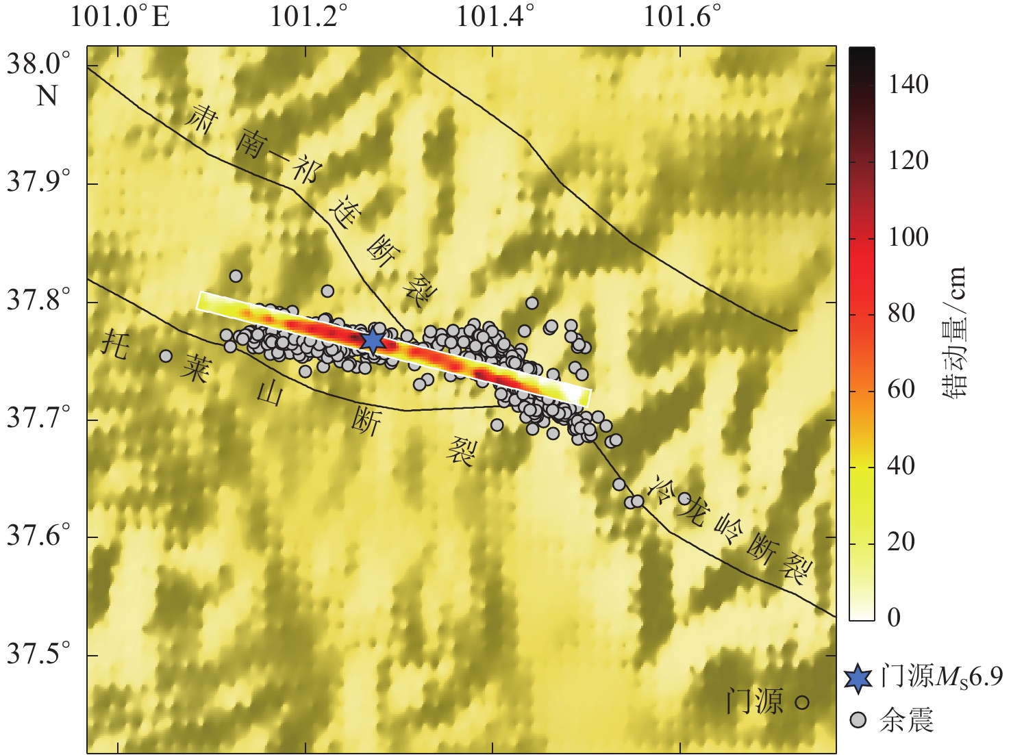
图 6 门源地震三维模型下的地震错动分布Figure 6. The fault slip distribution in the 3D model of Menyuan earthquake图7显示了断层面上的错动分布在地表的投影,发震断层面的倾角为84.6°,接近于垂直,由于破裂范围较大,所以发生明显错动的地表投影也长达34 km。
![]() 图 7 门源地震震源错动分布在地表的投影Figure 7. Surface projection of the fault slip distribution of Menyuan earthquake
图 7 门源地震震源错动分布在地表的投影Figure 7. Surface projection of the fault slip distribution of Menyuan earthquake4. 讨论与结论
在区域构造位置上,此次门源MS6.9地震发生在青藏高原东北缘,毗邻阿拉善地块与鄂尔多斯地块,西侧为塔里木盆地,位于冷龙岭断裂、托莱山断裂和肃南—祁连断裂的阶区部位,由于刚性地块内部构造变形较小,刚性地块之间的运动主要发生在其边界走滑断层上,总滑移量大、滑速快,通过走滑断层的运动转移地壳物质,可在同一地质领域内重新分配地壳厚度(Burchfiel et al,1987;England,Molnar,1997;Royden et al,1997;Zhang et al,2007)。该地区地质构造较为复杂,断裂带纵横交错,其中冷龙岭断裂带由一组几乎平行的WNW向左旋走滑断裂组成(李振洪等,2022). 根据震后现场科考结果,此次地震的发震构造是处于托莱山断裂与冷龙岭断裂之间阶区中的道沟断裂(中国地震局地质研究所,2022)。在构造应力上,研究地区主要受到印度板块NE向长期的挤压作用,应力不断积累,最终断层失稳而引发地震(刘泽民等,2022)。2016年门源地震引起的库仑应力增强区主要在其西北部,冷龙岭北断裂、肃南—祁连断裂、皇城—双塔断裂西端、民乐—大马营断裂东南端、托莱山断裂均存在较为明显的库仑应力增强(大于0.1 N/m2),这也为2022年门源地震的发生起到了促进作用(李振洪等,2022)。另外,发生在冷龙岭断裂北部的2016年门源地震的逆冲运动为冷龙岭断裂上的地震活动提供了空间(郭鹏等,2017)。从速度结构上看,门源地区地壳速度结构呈现出明显的横向不均匀性,中上地壳高速异常主要分布在冷龙岭断裂附近(左可桢,陈继锋,2018)。根据地震重定位结果和震级-破裂关系以及剪应力结果,门源MS6.9震源区下方可能存在高速异常障碍体,而且该地区的应力未得到充分释放,存在一定的应力积累,因而该地区仍然具有一定的强震危险性(许英才等,2022)。
GPS及相关研究表明,冷龙岭和托莱山两断裂的滑动速率差异较大,有学者认为冷龙岭断裂中西段晚第四纪以来的滑移速率可高达约15—19 mm/a (Gaudemer et al,1995;Lasserre et al,2002),在主震震中附近闭锁程度高,应力积累显著(石富强等,2018;Wang,Shen,2020)。因此,在具有不同滑动速率的冷龙岭断裂与托莱山断裂的交会处,变形不均性增大,弹性应变能累积,发生了此次门源地震。李振洪等(2022)利用InSAR获取2016年MS6.4和2022年MS6.9两次门源地震的同震地表形变场,探讨了两次地震的发震机制,初步判定本次地震为左旋走滑型地震,发震断层为冷龙岭西段,破裂最大错动达到3.5 m,位于地表下方4 km左右,且破裂至其西北端西侧的托莱山断裂。从震后现场考察可确定此次地震造成的地表破裂长达23 km,整个同震破裂以左旋走滑变形为主,具有双侧破裂特点(韩帅等,2022)。张旭等利用远场体波数据,采用W震相震源机制解反演了此次地震的破裂过程,最大滑移量约为1.2 m,且位置较为集中,位于震源偏下位置,破裂长度约30 km (中国地震局地球物理研究所,2022)。不同于InSAR或远震数据,本文采用区域测震台网数据对震源破裂过程进行反演,破裂最大位移约为1.5 m,位于约6 km深度,地表的破裂长度约为20 km,从图5a中看到,破裂主要集中在两个部分,也能印证双侧破裂的可能性。所以,不同手段得到的破裂反演结果还是有较大的差异。InSAR数据反演结果可能受主震前后几次M5.0左右地震的影响较大,且对深部的破裂分布约束较弱;而使用远震波形数据反演震源破裂过程,地震信号传播距离越远,受传播路径上横向不均匀性等各种因素的影响就越多(朱音杰等,2022),破裂过程反演结果比较依赖于发震断层参数的选取(张勇等,2014)。所以,不同尺度的参数设置,例如根据不同震级设置的子断层大小、滤波频段以及发震断层参数等,都会对反演结果产生影响。已有研究表明,子断层大小、截止频率都与地震的大小有关(Zheng et al,2020)。本文采用的子断层大小为2 km×2 km,介于上述两种方法之间;从地表破裂尺度来看,本方法与赵德政等利用Sentinel-1 SAR卫星数据得到的结果(中国地震局地质研究所,2022)较为一致,均为20 km左右,与张旭等利用远震数据反演得到的地表破裂30 km (中国地震局地球物理研究所,2022)有较大区别;在最大破裂尺度上,本文反演得到的1.5 m与利用远震数据反演结果1.2 m较为一致,与利用Sentinel-1 SAR或InSAR数据反演得到的3.5 m相差较大,这可能与主震之后的一次M5.0地震有关,并且这与采用地震波资料快速反演得到的破裂模型在滑动量方面可能存在一定低估(张勇等,2015)以及传播路径上的横向不均匀性、滤波频段等各种因素的影响也存在着很大的关系。另外,在一维模型下进行的有限断层反演,结构、地表地形的横向非均质性对滑动分布反演具有较大的影响,因为在三维模型中考虑了横向结构非均质性,可以减少震源的不确定性,因此在后续的研究中会利用三维模型构建的应变格林张量数据库来消除滑移分布反演中三维构造和地形的影响(Hsieh et al,2016)。综上,不同的参数设置和方法也会对数据结果产生影响。利用区域测震台网数据可以更快地反演震源破裂过程,受传播路径的影响较小,与震后现场考察在地表破裂尺度及双侧破裂特征方面的结果有较好的一致性。传统的破裂反演大都基于线性反演方法,相较于远震而言,在采用区域台站短周期数据的破裂反演过程中0.2 Hz已为较高频数据。Ji 等(2002)方法中的非线性搜索不依赖于初始解,并且采用非对称震源时间函数,这些是本文研究的相对优势。
本文基于有限断层模型,利用区域宽频带地震波形数据反演了门源MS6.9地震的震源破裂过程,得到如下结论:
1) 发震断层为节面 Ⅰ ,破裂主要集中在两个区域:一是在震源上方半径约3 km的圆形区域,最大错动量约为1.5 m,位于地下深度约6 km处,发生明显破裂的深度约为16 km,地震活动破裂至地表,最大错动量约为0.5 m,地表破裂长度约为20 km;二是沿走向方向,在震源右下方半径约3 km的圆形区域,最大错动量约1.2 m,位于深度约14 km处。
2) 此次地震释放的标量地震矩为1.23×10¹⁹ N·m,对应矩震级MW6.7,地震破裂持续17 s左右,单位能量释放在8 s左右达到极值,15 s时能量基本被释放。
3) 从破裂方向来看,破裂主要沿走向ESE方向传播,震源的两侧分别在2 s和9 s时出现破裂极大值,体现了双侧破裂的特征. 从地表错动分布图来看,发震断层面的倾角为84.6°,接近于垂直,由于破裂范围较大,所以发生明显错动分布的地表投影也长达34 km。
4) 此次地震存在两个明显特征:一是发震断层面倾角较大,且释放能量较高,出现了明显的地表破裂,长度可达约18 km;二是双侧破裂特征,从震源破裂过程中可以看出2 s和9 s时在震源两侧出现了错动极大值。从区域构造位置上也验证了初始破裂位于近EW 向的托莱山断裂,并触发了 NW−SE 向的冷龙岭断裂的结论,也与该地区复杂的构造环境有着密切的关系。
青藏高原地区一直是中外学者在地球动力学、地震学、构造地质学上研究的重点区域,走滑断层已被认为是新生代亚洲构造变形的重要构造,其运动导致了青藏高原的形成和演化(Molnar,Tapponnier,1975;Tapponnier,Molnar,1977),有效地调节了断层之间具有相对运动的大陆变形中的刚性地块(Replumaz,Tapponnier,2003)。构造地震使得研究区内构造的滑动速率减小,应变重新分布,主要走滑断层的位移向地壳短缩转变,祁连—海原断裂的左旋走滑可能在东部转变为六盘山的缩短和发育,也可能在一定程度上促进了该地区地质构造的变化 (Zheng et al,2013)。此次门源地震的发生,表明在断裂不连续位置发生破裂的复杂性,同时此次地震是否将青藏高原东北缘挤压作用的应力释放殆尽,尚需进一步研究。
通过地震波数据反演获得的地震参数以及破裂过程仍需详细的地震地质调查资料的验证。野外现场考察能够及时确定这次地震地表破裂带的空间展布、构造组合和位移分布特征,获取其滑移习性等参数(潘家伟等,2022)。地震现场考察结果显示,冷龙岭断裂具有枢纽状走滑断裂的几何学特征,断裂东西两段均存在明显的地貌反差,为一条具有区域性构造控制性作用的大型断裂,沿着该断裂特征性地震的发震能力一般在M7.5以上(韩竹军等,2022)。因此,采用高效的算法和可靠的数据进行地震动预测以及进一步评估该区未来的强震活动趋势,是震后需要及时研判的重要问题。
特别感谢中国地震局地球物理研究所房立华研究员为本研究提供数据支持。文中图件均由GMT (Wessel et al,2019)绘制。
1 ① 王卫民,何建坤,郝金来。2022。2022年1月8日青海门源M6.9地震震源破裂过程反演初步结果。学术讨论资料。 -
![]()
图 5 以震源机制解中节面Ⅰ为断层面反演得到的震源破裂过程
(a) 错动在断层面上的分布,黑色等值线为破裂开始时间;(b) 地震矩释放率函数
Figure 5. Slip distribution obtained by using nodal plane I in the focal mechanism solution as the fault plane
(a) Slip distribution on the fault plane,where the black contours display the rupture initial time in second;(b) Seismic moment release rate as a function of time
![]()
图 1 青藏高原东北缘构造背景和2010—2022年ML≥3.0地震分布
红色六角星为两次MS≥6.0地震的震中;沙滩球为MS≥5.0地震的震源机制解;右上角为研究区位置及地块运动方向示意图,图中红色箭头指示地块运动方向,黑色方框为研究区;左下角为 2022年1月门源MS6.9地震震中及周边(绿色方框)MS≥5.0地震的震源机制解,F1:肃南—祁连断裂,F2:托莱山断裂;F3:冷龙岭断裂
Figure 1. Tectonic settings and distribution of ML≥3.0 earthquakes from 2010 to 2022 in the northeastern margin of Tibetan Plateau
The red stars are epicenters of two MS≥6.0 earthquakes,beach balls show focal mechanisms of the earthquakes with MS≥5.0. The upper-right inset gives the location of study area (black box) and the schematic illustration of block motion directions,where red arrows indicate the directions of block movements. The lower-left inset shows the epicenter of the January 2022 Menyuan MS6.9 earthquake and focal mechanism solutions of MS≥5.0 earthquakes in the surrounding region,F1:Su’nan-Qilian fault;F2:Tuolaishan fault;F3:Lenglongling fault
![]()
图 2 本研究中用来反演震源机制解及破裂过程的地壳分层速度模型
Figure 2. Layered crustal velocity model used in the inversions of focal mechanism solution and rupture process in this study
![]()
图 3 2022年1月门源MS6.9地震的余震分布
(a) 地表投影;(b) 在AB剖面上的投影;(c) 在CD剖面上的投影
Figure 3. Distribution of the aftershocks of the January 2022 Menyuan MS6.9 earthquake
(a) Projection of aftershocks on the surface;(b) Projection of aftershocks on the cross section AB; (c) Projection of aftershocks on the cross section CD
![]()
图 4 门源地震震中位置及周边台站分布图(a)和以节面 Ⅰ 为断层面反演的波形拟合(b)
黑色与红色波形分别为观测波形与理论波形;每组波形上面给出了台站名称,从上至下分别为东西、南北、垂直三个分量,波形上的数字为最大振幅,单位为cm
Figure 4. The epicenter of Menyuan earthquake and distribution of surrounding stations (a) and waveform fitting when using nodal plane Ⅰ as the fault plane in slip distribution inversion (b)
Black and red traces are observed and synthetic waveforms,respectively. On the set of waveforms are the code of the station,and the waveforms are EW,SN and UD components from up to down. The number above each trace indicates the maximum amplitude of the data in unit of cm
![]()
图 6 门源地震三维模型下的地震错动分布
Figure 6. The fault slip distribution in the 3D model of Menyuan earthquake
-
陈文彬. 2003. 河西走廊及邻近地区最新构造变形基本特征及构造成因分析[D]. 北京: 中国地震局地质研究所: 59–69. Chen W B. 2003. Principal Features of Tectonic Deformation and Their Generation Mechanism in the Hexi Corridor and Its Adjacent Regions Since Late Quaternary[D]. Beijing: Institute of Geology, China Earthquake Administration: 59–69 (in Chinese).
范莉苹,李珀任,廖诗荣,蒋策,房立华. 2022. 2022 年 1 月 8 日青海门源 MS6.9 地震余震序列精定位研究[J]. 地震学报,35(2):138–145. Fan L P,Li B R,Liao S R,Jiang C,Fang L H. 2022. Precise relocation of the aftershock sequences of the 2022 M6.9 Menyuan earthquake[J]. Acta Seismologica Sinica,35(2):138–145 (in Chinese). doi: 10.1016/j.eqs.2022.01.021
国家地震局地质研究所, 宁夏回族自治区地震局. 1990. 海原活动断裂带[M]. 北京: 地震出版社: 99–138. Institute of Geology, State Seismological Bureau, Seismological Bureau of Ningxia Hui Autonomous Region. 1990. Haiyuan Active Fault System[M]. Beijing: Seismological Press: 99–138 (in Chinese).
郭鹏,韩竹军,安艳芬,姜文亮,毛泽斌,冯蔚. 2017. 冷龙岭断裂系活动性与2016年门源6.4级地震构造研究[J]. 中国科学:地球科学,47:617–630. Guo P,Han Z J,An Y F,Jiang W L,Mao Z B,Feng W. 2017. Activity of the Lenglongling fault system and seismotectonics of the 2016 MS6.4 Menyuan earthquake[J]. Science China Earth Sciences,60:929–942.
韩帅,吴中海,高扬,卢海峰. 2022. 2022年1月8日青海门源MS6.9地震地表破裂考察的初步结果及对冷龙岭断裂活动行为和区域强震危险性的启示[J]. 地质力学学报,28(2):155–168. Han S,Wu Z H,Gao Y,Lu H F. 2022. Surface rupture investigation of the 2022 Menyuan MS6.9 earthquake,Qinghai,China:Implications for the fault behavior of the Lenglongling fault and regional intense earthquake risk[J]. Journal of Geomechanics,28(2):155–168 (in Chinese).
韩竹军, 牛鹏飞, 李科长, 吕丽星. 2022. 2022年1月8日青海门源6.9级地震的一些初步认识[EB/OL]. [2022-01-18]. https://www.eq-igl.ac.cn/zhxw/info/2022/36632.html. Han Z J, Niu P F, Li K Z, Lü L X. 2022. Primary understanding of the MS6.9 Menyuan earthquake on January 8, 2022 in Qinghai Province[EB/OL]. [2022-01-18]. https://www.eq-igl.ac.cn/zhxw/info/2022/36632.html (in Chinese).
何文贵,刘百篪,袁道阳,杨明. 2000. 冷龙岭活动断裂的滑动速率研究[J]. 西北地震学报,22(1):90–97. He W G,Liu B C,Yuan D Y,Yang M. 2000. Research on slip rates of the Lenglongling active fault zone[J]. Northwestern Seismological Journal,22(1):90–97 (in Chinese).
何文贵,袁道阳,葛伟鹏,罗浩. 2010. 祁连山活动断裂带中东段冷龙岭断裂滑动速率的精确厘定[J]. 地震,30(1):131–137. doi: 10.3969/j.issn.1000-3274.2010.01.015 He W G,Yuan D Y,Ge W P,Luo H. 2010. Determination of the slip rate of the Lenglongling fault in the middle and eastern segments of the Qilian mountain active fault zone[J]. Earthquake,30(1):131–137 (in Chinese).
李祥,万永革,崔华伟,高熹微,黄骥超,张珊珊. 2016. 2016年1月21日青海门源 MS6.4 地震构造应力场[J]. 华北地震科学,34(2):36–41. doi: 10.3969/j.issn.1003-1375.2016.02.007 Li X,Wan Y G,Cui H W,Gao X W,Huang J C,Zhang S S. 2016. Tectonic stress field of 2016,MS6.4 Menyuan,Qinghai earthquake[J]. North China Earthquake Sciences,34(2):36–41 (in Chinese).
李振洪,韩炳权,刘振江,张苗苗,余琛,陈博,刘海辉,杜静,张双成,朱武,张勤,彭建兵. 2022. InSAR 数据约束下的 2016 年和 2022 年青海门源地震震源参数及其滑动分布[J]. 武汉大学学报(信息科学版),47(6):887–897. Li Z H,Han B Q,Liu Z J,Zhang M M,Yu C,Chen B,Liu H H,Du J,Zhang S C,Zhu W,Zhang Q,Peng J B. 2022. Source parameters and slip distributions of the 2016 and 2022 Menyuan,Qinghai earthquakes constrained by InSAR observations[J]. Geomatics and Information Science of Wuhan University,47(6):887–897 (in Chinese).
李智敏,盖海龙,李鑫,袁道阳,谢虹,姜文亮,李永生,苏琦. 2022. 2022年青海门源MS6.9级地震发震构造和地表破裂初步调查[J]. 地质学报,96(1):330–335. Li Z M,Gai H L,Li X,Yuan D Y,Xie H,Jiang W L,Li Y S,Su Q. 2022. Seismogenic fault and coseismic surface deformation of the Menyuan MS6.9 earthquake in Qinghai,China[J]. Acta Geologica Sinica,96(1):330–335 (in Chinese).
刘成利,郑勇,葛粲,熊熊,许厚泽. 2013. 2013年芦山7.0级地震的动态破裂过程[J]. 中国科学:地球科学,43(6):1020–1026. Liu C L, Zheng Y, Ge C, Xiong X, Xu H Z. 2013. Rupture process of the MS7.0 Lushan earthquake, 2013[J]. Science China Earth Sciences, 56(7): 1187−1192. doi: 10.1007/s11430-013-4639-9.
刘成利,郑勇,熊熊,付芮,单斌,刁法启. 2014. 利用区域宽频带数据反演鲁甸MS6.5 级地震震源破裂过程[J]. 地球物理学报,57(9):3028–3037. doi: 10.6038/cjg20140927 Liu C L,Zheng Y,Xiong X,Fu R,Shan B,Diao F Q. 2014. Rupture process of MS6.5 Ludian earthquake constrained by regional broadband seismograms[J]. Chinese Journal of Geophysics,57(9):3028–3037 (in Chinese).
刘泽民,张广伟,梁姗姗,邹立晔. 2022. 2022年青海门源 MS6.9地震余震的空间迁移特征[J]. 地震工程学报,44(1):475–487. Liu Z M,Zhang G W,Liang S S,Zou L Y. 2022. Spatial migration characteristics of the aftershock sequence of the Menyuan,Qinghai MS6.9 earthquake in 2022[J]. China Earthquake Engineering Journal,44(1):475–487 (in Chinese).
潘家伟,李海兵,Chevalier M L,刘栋梁,李超,刘富财,吴琼,卢海建,焦利青. 2022. 2022年青海门源MS6.9地震地表破裂带及发震构造研究[J]. 地质学报,96(1):215–231. doi: 10.3969/j.issn.0001-5717.2022.01.018 Pan J W,Li H B,Chevalier M L,Liu D L,Li C,Liu F C,Wu Q,Lu H J,Jiao L Q. 2022. Coseismic surface rupture and seismogenic structure of the 2022 MS6.9 Menyuan earthquake,Qinghai Province,China[J]. Acta Geologica Sinica,96(1):215–231 (in Chinese).
石富强,邵志刚,占伟,丁晓光,朱琳,李玉江. 2018. 青藏高原东北缘活动断裂剪切模量及应力状态数值模拟[J]. 地球物理学报,61(9):3651–3663. doi: 10.6038/cjg2018L0631 Shi F Q,Shao Z G,Zhan W,Ding X G,Zhu L,Li Y J. 2018. Numerical modeling of the shear modulus and stress state of active faults in the northeastern margin of the Tibetan Plateau[J]. Chinese Journal of Geophysics,61(9):3651–3663 (in Chinese).
徐锡伟,吴熙彦,于贵华,谭锡斌,李康. 2017. 中国大陆高震级地震危险区判定的地震地质学标志及其应用[J]. 地震地质,39(2):219–275. Xu X W,Wu X Y,Yu G H,Tan X B,Li K. 2017. Seismo-geological signatures for identifying M≥7.0 earthquake risk areas and their premilimary application in mainland China[J]. Seismology and Geology,39(2):219–275 (in Chinese).
许英才,郭祥云,冯丽丽. 2022. 2022年1月8日青海门源MS6.9地震序列重定位和震源机制解研究[J]. 地震学报,44(2):195–210. Xu Y C,Guo X Y,Feng L L. 2022. Relocation and focal mechanism solutions of the MS6.9 Menyuan earthquake sequence on January 8,2022 in Qinghai Province[J]. Acta Seismologica Sinica,44(2):195–210 (in Chinese).
袁道阳,张培震,刘百篪,甘卫军,毛凤英,王志才,郑文俊,郭华. 2004. 青藏高原东北缘晚第四纪活动构造的几何图像与构造转换[J]. 地质学报,78(2):270–278. doi: 10.3321/j.issn:0001-5717.2004.02.017 Yuan D Y,Zhang P Z,Liu B C,Gan W J,Mao F Y,Wang Z C,Zheng W J,Guo H. 2004. Geometrical imagery and tectonic transformation of Late Quaternary active tectonics in northeastern margin of Qinghai-Xizang Plateau[J]. Acta Geologica Sinica,78(2):270–278 (in Chinese).
张勇,许力生,陈运泰,汪荣江. 2014. 2014年2月12日于田MW6.9地震破裂过程初步反演:兼论震源机制对地震破裂过程反演的影响[J]. 地震学报,36(2):159–164. doi: 10.3969/j.issn.0253-3782.2014.02.001 Zhang Y,Xu L S,Chen Y T,Wang R J. 2014. Fast inversion for the rupture process of the 12 February 2014 Yutian MW6.9 earthquake:Discussion on the impacts of focal mechanism on rupture process inversions[J]. Acta Seismologica Sinica,36(2):159–164 (in Chinese).
张勇,陈运泰,许力生,魏星,金明培,张森. 2015. 2014年云南鲁甸MW6.1地震:一次共轭破裂地震[J]. 地球物理学报,58(1):153–162. doi: 10.6038/cjg20150113 Zhang Y,Chen Y T,Xu L S,Wei X,Jin M P,Zhang S. 2015. The 2014 MW6.1 Ludian,Yunnan,earthquake:A complex conjugated ruptured earthquake[J]. Chinese Journal of Geophysics,58(1):153–162 (in Chinese).
中国地震局地球物理研究所. 2022. 2022年01月08日青海海北州门源县6.9级地震科技支撑简报[EB/OL]. [2022-01-10]. https://www.cea-igp.ac.cn/kydt/278809.html. Institute of Geophysics, China Earthquake Administration. 2022. A brief of the MS6.9 Menyuan earthquake on January 8, 2022 in Qinghai Province[EB/OL]. [2022-01-10]. https://www.cea-igp.ac.cn/kydt/278809.html (in Chinese).
中国地震局地质研究所. 2022. 2022年01月08日青海海北州门源县6.9级地震科技支撑简报[EB/OL]. [2022-01-14]. https://www.eq-igl.ac.cn/kydt/info/2022/36614.html. Institute of Geology, China Earthquake Administration. 2022. A brief of the MS6.9 Menyuan earthquake on January 8, 2022 in Qinghai Province [EB/OL]. [2022-01-14]. https://www.eq-igl.ac.cn/kydt/info/2022/36614.html (in Chinese).
中国地震台网中心. 2022. 青海海北州门源县6.9级地震[EB/OL]. [2022-01-10]. https://news.ceic.ac.cn/CC20220108014528.html. China Earthquake Networks Center. 2022. MS6.9 Menyuan earthquake in Haibei Prefecture, Qinghai Province[EB/OL]. [2022-01-10]. https://news.ceic.ac.cn/CC20220108014528.html (in Chinese).
钟世军,吴建平,房立华,王未来,范莉苹,王怀富. 2017. 青藏高原东北缘及周边地区基于程函方程的面波层析成像[J]. 地球物理学报,60(6):2304–2314. doi: 10.6038/cjg20170622 Zhong S J,Wu J P,Fang L H,Wang W L,Fan L P,Wang H F. 2017. Surface wave Eikonal tomography in and around the northeastern margin of the Tibetan Plateau[J]. Chinese Journal of Geophysics,60(6):2304–2314 (in Chinese).
朱音杰,罗艳,赵里,田建慧. 2022. 利用区域宽频地震数据反演2021年5月云南漾濞MS6.4地震震源破裂过程[J]. 地球物理学报,65(3):1021–1031. doi: 10.6038/cjg2022P0443 Zhu Y J,Luo Y,Zhao L,Tian J H. 2022. Rupture process of Yunnan Yangbi MS6.4 earthquake constrained by regional broadband seismograms[J]. Chinese Journal of Geophysics,65(3):1021–1031 (in Chinese).
周琳,季灵运,李长军,李君. 2022. 利用小震和 GPS 资料分析冷龙岭地区现今变形过程与地震活动[J]. 地震研究,45(3):416–423. Zhou L, Ji L Y, Li Z J, Li J. 2022. Study on current deformation process and seismicity of Lenglongling area based on small earthquakes and GPS Data[J]. Journal of Seismological Research, 45(3): 416–423 (in Chinese).
左可桢,陈继锋. 2018. 门源地区地壳三维体波速度结构及地震重定位研究[J]. 地球物理学报,61(7):2788–2801. doi: 10.6038/cjg2018L0537 Zuo K Z,Chen J F. 2018. 3D body-wave velocity structure of crust and relocation of earthquakes in the Menyuan area[J]. Chinese Journal of Geophysics,61(7):2788–2801 (in Chinese).
Aki K, Richards P G. 1980. Quantitative Seismology: Theory and Methods[M]. San Francisco: W. H. Freeman & Co.: 1−813.
Burchfiel B C,Hodges K V,Royden L H. 1987. Geology of Panamit Valley-Saline Valley pull-apart system,California:Palinspastic evidence for low-angle geometry of a Neogene range-bounding fault[J]. J Geophys Res:Solid Earth,92(B10):10422–10426.
England P,Molnar P. 1997. Active deformation of Asia:From kinematics to dynamics[J]. Science,278(5338):647–650. doi: 10.1126/science.278.5338.647
Gaudemer Y,Tapponnier P,Meyer B,Peltzer G,Guo S M,Chen Z T,Dai H G,Cifuentes I. 1995. Partitioning of crustal slip between linked,active faults in the eastern Qilian Shan,and evidence for a major seismic gap,the ‘Tianzhu gap’,on the western Haiyuan fault,Gansu (China)[J]. Geophys J Int,120(3):599–645.
Guo P,Han Z J,Dong S,Yuan R M,Xie Z D. 2019a. Surface rupture and slip distribution along the Lenglongling fault in the NE Tibetan Plateau:Implications for faulting behavior[J]. J Asian Earth Sci,172:190–207. doi: 10.1016/j.jseaes.2018.09.008
Guo P,Han Z J,Mao Z B,Xie Z D,Dong S P,Gao F,Gai H L. 2019b. Paleoearthquakes and rupture behavior of the Lenglongling fault:Implications for seismic hazards of the northeastern margin of the Tibetan Plateau[J]. J Geophys Res:Solid Earth,124(2):1520–1543. doi: 10.1029/2018JB016586
Guo P,Han Z J,Gao F,Zhu C H,Gai H L. 2020. A new tectonic model for the 1927 M8.0 Gulang earthquake on the NE Tibetan Plateau[J]. Tectonics,39(9):e2020TC006064.
Han S C,Zhang H J,Xin H L,Shen W S,Yao H J. 2022. USTClitho2.0:Updated unified seismic tomography models for continental China lithosphere from joint inversion of body-wave arrival times and surface-wave dispersion data[J]. Seismol Res Lett,93(1):201–205.
Hsieh M C,Zhao L,Ji C,Ma K F. 2016. Efficient inversions for earthquake slip distributions in 3D structures[J]. Seismol Res Lett,87(6):1342–1354. doi: 10.1785/0220160050
Ji C, Wald D J, Helmberger D V. 2002. Source description of the 1999 Hector Mine, California, earthquake, part I: Wavelet domain inversion theory and resolution analysis[J], Bull Seismol Soc Am, 92(4): 1192–1207.
Ji C, Helmberger D V, Wald D J, Ma K F. 2003. Slip history and dynamic implications of the 1999 Chi-Chi, Taiwan, earthquake[J]. J Geophys Res: Solid Earth, 108(B9): 2412.
Lasserre C,Gaudemer Y,Tapponnier P,Mériaux A S,Yuan D Y,Ryerson F J,Finkel R C,Caffee M W. 2002. Fast Late Pleistocene slip rate on the Leng Long Ling segment of the Haiyuan fault,Qinghai,China[J]. J Geophys Res:Solid Earth,107(B11):2276.
Molnar P,Tapponnier P. 1975. Cenozoic tectonics of Asia:Effects of a continental collision[J]. Science,189(4201):419–426. doi: 10.1126/science.189.4201.419
Replumaz A,Tapponnier P. 2003. Reconstruction of the deformed collision zone between India and Asia by backward motion of lithospheric blocks[J]. J Geophys Res:Solid Earth,108(B6):2285.
Royden L,Burchfiel B C,King R W,Wang E,Chen Z,Shen F,Liu Y. 1997. Surface deforlations of a population of very small rift-related normal faults[J]. Geology,24:683–686.
Shao G,Li X Y,Ji C. 2011. Focal mechanism and slip history of the 2011 MW9.1 of the Pacific coast of Tohoku earthquake,constrained with teleseismic body and surface waves[J]. Earth Planets Space,63(7):559–564. doi: 10.5047/eps.2011.06.028
Tapponnier P, Molnar P. 1977. Active faulting and tectonics in China[J]. J Geophys Res: Solid Earth, 82: 2905–2930.
Tapponnier P,Meyer B,Avouac J P,Peltzer G,Gaudemer Y,Guo S M,Xiang H F,Yin K L,Chen Z T,Cai S H,Dai H G. 1990. Active thrusting and folding in the Qilian Shan,and decoupling between upper crust and mantle in northeastern Tibet[J]. Earth Planet Sci Lett,97(3/4):382–403.
Tapponnier P,Xu Z Q,Roger F,Meyer B,Arnaud N,Wittlinger G. 2001. Oblique stepwise rise and growth of the Tibet Plateau[J]. Science,294(5547):1671–1677. doi: 10.1126/science.105978
Wei S J,Helmberger D,Avouac J P. 2013. Modeling the 2012 Wharton basin earthquakes off-Sumatra:Complete lithospheric failure[J]. J Geophys Res:Solid Earth,118(7):3592–3609. doi: 10.1002/jgrb.50267
Wessel P,Luis J F,Uieda L,Scharroo R,Wobbe F,Smith W H F,Tian D. 2019. The Generic Mapping Tools version 6[J]. Geochem Geophys Geosyst,20:5556–5564.
Wang M,Shen Z K. 2020. Present-day crustal deformation of continental China derived from GPS and its tectonic implications[J]. J Geophys Res:Solid Earth,125(2):e2019JB018774.
Xu X W,Yeats R S,Yu G H. 2010. Five short historical earthquake surface ruptures near the Silk Road,Gansu Province,China[J]. Bull Seismol Soc Am,100(2):541–561. doi: 10.1785/0120080282
Zhang P Z,Molnar P,Xu X W. 2007. Late Quaternary and present-day rates of slip along the Altyn Tagh fault,northern margin of the Tibetan Plateau[J]. Tectonics,26(5):TC5010.
Zhang W Q,Jiao D C,Zhang P Z,Molnar P,Burchfield B C,Deng Q D,Wang Y P,Song F M. 1987. Displacement along the Haiyuan fault associated with the great 1920 Haiyuan,China,earthquake[J]. Bull Seismol Soc Am,77(1):117–131.
Zheng W J,Zhang P Z,He W G,Yuan D Y,Shao Y X,Zheng D W,Ge W P,Min W. 2013. Transformation of displacement between strike-slip and crustal shortening in the northern margin of the Tibetan Plateau:Evidence from decadal GPS measurements and Late Quaternary slip rates on faults[J]. Tectonophysics,584:267–280. doi: 10.1016/j.tecto.2012.01.006
Zheng X J, Zhang Y, Wang R J, Zhao L, Li W Y, Huang Q H. 2020. Automatic inversions of strong-motion records for finite-fault models of significant earthquakes in and around Japan[J]. J Geophys Res: Solid Earth, 125(9): e2020JB019992.
Zhu L P,Rivera L A. 2002. A note on the dynamic and static displacements from a point source in multilayered media[J]. Geophys J Int,148(3):619–627. doi: 10.1046/j.1365-246X.2002.01610.x
-
期刊类型引用(1)
1. 张海,高俊焱,王岱,刘中宪,李程程,张聪. 青海门源M_S6.9地震强地面运动精细化模拟. 震灾防御技术. 2023(03): 462-470 .  百度学术
百度学术
其他类型引用(2)

 下载:
下载:


计量
- 文章访问数: 678
- HTML全文浏览量: 213
- PDF下载量: 185
- 被引次数: 3
