

Probability hazard analysis of potential earthquake-induced landslide:A case study of Longxian County, Shaanxi Province
-
摘要: 采用第五代地震动参数区划图的潜在震源区划分方案并结合Newmark位移模型,基于陇县工程地质岩性特征及地形高程数据,考虑地震动地形放大效应以及Newmark模型参数的不确定性,得出陕西陇县地区的地震动发生率为50年10%水平下滑坡的失稳概率,根据所得结果将研究区的潜在地震滑坡危险程度分为四个等级:极低危险区、低危险区、中危险区、高危险区。中、高危险区主要集中于陇县地区的泥岩、粉砂岩以及黄土覆盖地且斜坡坡度大于 40° 的地区,其中千河及其通关河两岸部分地区的地震滑坡危险性较高。本文结果可为该地区的地震滑坡风险管理和土地规划提供参考。
-
关键词:
- 地震滑坡 /
- 潜在震源区 /
- Newmark累积位移 /
- 地震危险性分析 /
- 地震发生率
Abstract: In this paper, the potential focal area division scheme of the Fifth Generation Seismic Parameter Zoning Map of China combined with the Newmark displacement model is adopted. And according to the engineering geological lithology and topographic elevation data of Longxian, the amplification effect of topography on ground motion and the uncertainty of parameters of Newmark model are also considered. Above all, the instability probability of landslide in Longxian county, Shaanxi Province is given on the condition that the earthquake incidence rate is 10% in 50 years. According to the results, potential earthquake-induced landslide in the study area can be divided into four grades: the very low risk area, the low risk areas, the medium risk areas and the high risk areas. And the high risk areas are mainly concentrated in the mudstone, siltstone and loess covered areas with a slope of more than 40° in Longxian. Among them, Qianhe river and some areas on both sides of Tongguanhe river have higher seismic landslide risk. The results can provide a reference for seismic landslide risk management and land planning in this area. -
本目录中的地震参数来自“中国地震台站观测报告”(简称“月报”). 其中, 国内及邻区给出M≥4.7的事件, 全球给出M≥6.0的事件. “月报”由中国地震台网中心按月做出.
本目录中的发震时刻采用协调世界时(UTC); 为了方便中国读者, 也给出北京时(BTC). 震中位置除给出经纬度外, 还给出参考地区名, 它仅用作查阅参考, 不包含任何政治意义; 还给出测定震源位置的台数(n)和标准偏差(SD).
面波震级MS是用中周期宽频带SK地震仪记录, 采用北京台1965年面波震级公式MS=lg(AH/T)+1.66 lg(Δ)+3.5 (1°<Δ<130°)求得. AH是两水平分向最大面波位移的矢量合成位移. MS7是对763长周期地震仪记录, 采用国际上推荐的面波震级公式MS7=lg(AV/T)+1.66 lg(Δ)+3.3 (20°<Δ<160°)求得. AV是垂直向面波最大地动位移. mb是短周期体波震级, ML是近震震级, 为避免混乱, 震级之间一律不换算.
表 1 中国及邻区地震目录(2015年9—10月, M≥4.7)Table 1. Catalog of earthquakes within and near China (September--October, 2015, M≥4.7)编号 发 震 时 刻 地 理 坐 标 深度/km 震级 标准偏差(SD) 使用台数 (n) 地 区 UTC BTC 日-时 纬度/°N 经度/°E M S M S7 ML mb 月-日 时:分:秒 1 09-01 13:24:44.8 01-21 23.93 121.54 10 5.2 5.1 5.2 4.7 2.3 96 台湾岛 2 01 17:34:06.8 02-01 24.06 122.41 21 4.7 4.6 4.4 4.4 2.0 76 台湾岛 3 13 07:51:10.8 13-15 45.08 91.52 7 4.7 4.3 5.0 4.6 2.2 69 新疆自治区北部 4 15 19:37:33.2 16-03 24.35 121.90 10 5.6 5.5 5.7 5.0 1.6 98 台湾岛 5 16 11:10:07.7 16-19 35.46 78.47 8 4.5 4.2 4.9 4.6 2.2 66 克什米尔东部 6 16 13:08:57.1 16-21 24.25 121.90 10 5.3 5.2 5.4 4.9 1.6 101 台湾岛 7 10-12 10:04:14.7 12-18 34.36 98.20 10 5.3 5.1 5.1 4.9 2.6 92 青海省 8 12 11:14:46.8 12-19 22.47 121.48 12 4.7 4.4 4.9 4.5 1.7 84 台湾地区 9 19 02:17:36.1 19-10 24.93 122.00 10 5.5 5.3 5.6 4.9 1.9 97 台湾岛 10 19 05:42:13.1 19-13 24.97 121.79 10 4.7 4.5 4.5 4.4 2.2 71 台湾岛 11 19 07:20:16.7 19-15 24.98 121.99 10 4.7 4.5 4.6 4.4 1.9 73 台湾岛 12 21 05:58:21.0 21-13 44.68 124.16 10 4.5 4.3 5.1 4.3 2.0 50 中国东北部 13 26 18:11:23.8 27-02 30.17 98.01 6 4.6 4.4 4.4 4.7 2.3 58 西藏自治区 14 28 20:12:08.5 29-04 27.55 100.30 10 4.8 4.6 4.5 4.5 2.5 78 云南省 15 30 11:26:39.4 30-19 25.04 99.44 10 5.0 4.7 5.1 4.7 2.5 84 缅甸—中国边境地区 表 2 全球地震目录(2015年9—10月, M≥6.0)Table 2. Catalog of earthquakes all over the world (September--October, 2015, M≥6.0)编号 发 震 时 刻 地 理 坐 标 深度/km 震级 标准偏差(SD) 使用台数 (n) 地 区 UTC BTC 日-时 纬度/° 经度/° MS MS7 mb 月-日 时:分:秒 1 09-01 15:25:06.6 01-23 31.19N 141.88E 20 6.1 5.9 5.3 1.6 67 本州以南地区 2 07 09:13:56.6 07-17 33.07S 177.99W 29 6.2 5.9 5.4 1.7 74 克马德克群岛以南地区 3 07 14:06:24.7 07-22 32.98S 177.83W 12 6.0 5.7 5.3 1.9 84 克马德克群岛以南地区 4 08 08:03:55.0 08-16 14.70N 93.90W 10 6.0 5.7 1.4 56 墨西哥恰帕斯海岸近海 5 10 10:26:42.3 10-18 52.46N 169.64W 18 6.0 5.9 5.6 1.1 98 福克斯群岛 6 13 08:14:10.0 13-16 25.14N 109.38W 10 6.8 6.7 5.5 2.6 64 加利福尼亚湾 7 16 07:40:57.5 16-15 1.89N 126.42E 50 6.1 6.0 5.7 1.3 101 马鲁古海峡 8 16 14:03:21.7 16-22 6.03S 151.48E 20 6.0 5.8 5.3 1.6 102 新不列颠地区 9 16 22:54:31.5 17-06 31.59S 71.62W 20 8.3 8.3 1.3 80 中智利海岸近海 10 16 23:18:40.3 17-07 31.45S 71.20W 30 6.8 6.8 2.3 91 中智利海岸近海 11 17 01:41:10.2 17-09 31.10S 71.45W 40 6.4 6.4 1.4 88 中智利海岸近海 12 17 03:55:17.5 17-11 31.10S 71.35W 40 6.5 6.5 1.9 67 中智利海岸近海 13 17 04:10:27.7 17-12 31.55S 71.70W 30 6.9 6.9 2.8 94 中智利海岸近海 14 18 09:10:50.0 18-17 32.25S 72.10W 25 6.3 6.3 2.3 93 中智利海岸近海 15 18 15:59:42.5 18-23 15.30N 46.00W 10 6.2 6.0 2.5 53 北大西洋海岭 16 19 12:52:19.7 19-20 32.25S 71.80W 10 6.4 6.4 1.4 99 中智利海岸近海 17 19 13:08:56.5 19-21 30.89S 72.68W 10 6.3 6.0 3.1 37 中智利海岸近海 18 21 05:39:32.6 21-13 31.55S 71.70W 20 6.2 6.1 1.2 92 中智利海岸近海 19 21 17:39:57.4 22-01 31.65S 71.60W 20 6.8 6.8 1.3 95 中智利海岸近海 20 24 15:53:28.8 24-23 0.55S 131.25E 30 6.5 6.2 5.9 1.3 97 西伊里安地区 21 24 15:56:53.8 24-23 9.81S 160.70E 18 6.4 6.2 5.9 0.7 71 所罗门群岛 22 26 02:51:15.7 26-10 30.80S 71.30W 30 6.3 6.3 1.2 102 中智利海岸近海 23 10-11 00:58:29.0 11-08 54.60S 135.80W 10 6.0 5.8 3.0 40 南太平洋山系 24 14 05:43:04.0 14-13 48.88N 156.25E 10 6.3 6.3 5.6 1.3 99 千岛群岛 25 17 11:33:08.0 17-19 24.89S 64.31W 10 6.0 5.9 2.2 74 阿根廷萨尔塔省 26 20 21:52:0.0 21-05 14.82S 167.32E 130 6.2 1.3 82 瓦努阿图(新赫布里底) 27 26 09:09:31.2 26-17 36.59N 70.79E 207 6.1 0.9 94 兴都库什地区 -
![]()
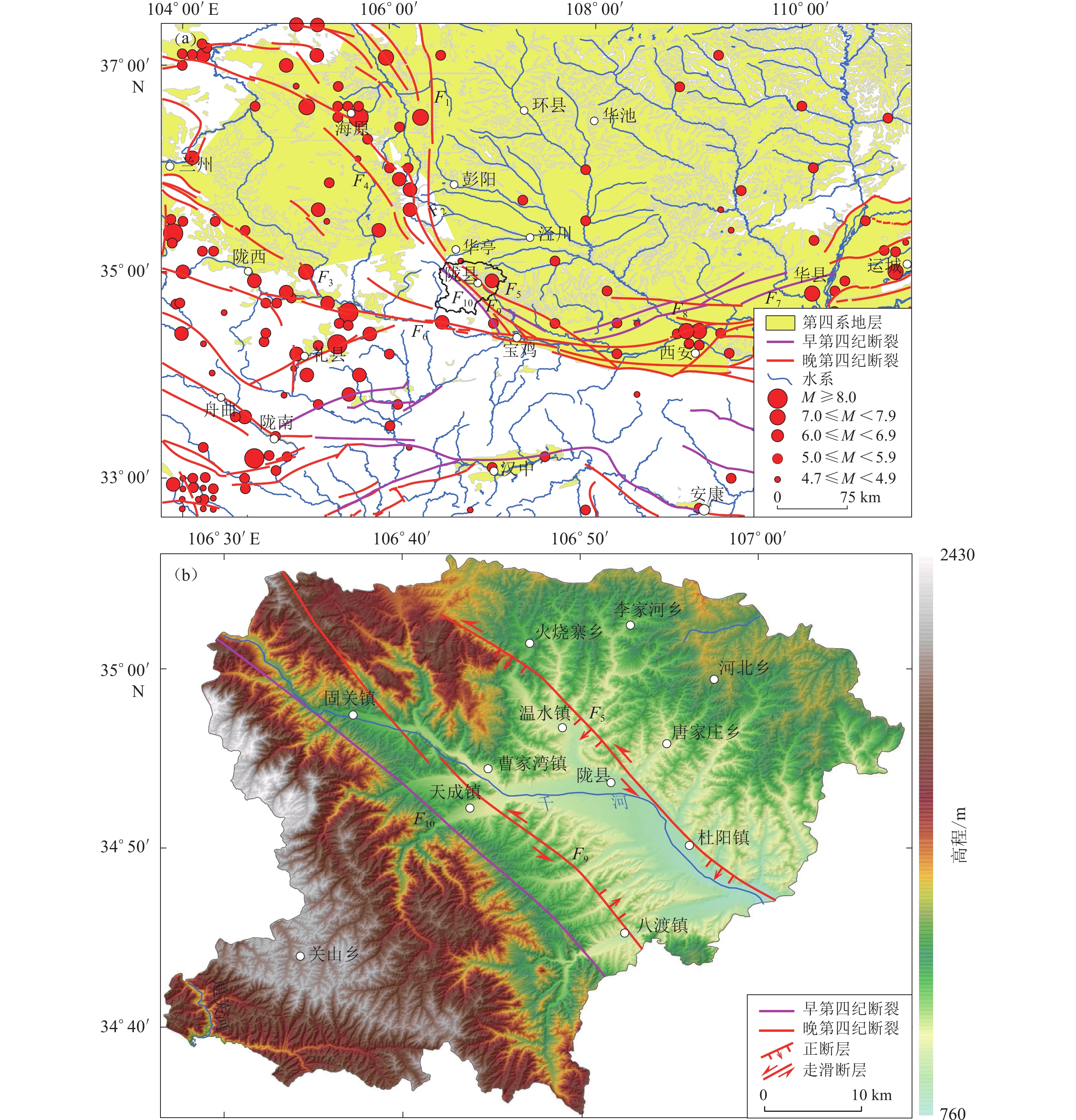
图 1 区域地震构造及地形地貌图
(a) 研究区及周边地震和断裂分布图;(b) 陇县的数字高程模型。F1:六盘山断裂带;F2:小关山断裂; F3:通渭断裂;F4:海原断裂;F5:岐山—马召断裂;F6:西秦岭断裂;F7:双泉—临猗断裂;F8:扶风—三原—蒲城断裂;F9:固关—宝鸡断裂;F10:桃园—龟川寺断裂
Figure 1. The topography and tectonic settings of the study area
(a) Major active faults and large earthquakes around the study area;(b) The digital elevation model of the Longxian county. F1:Liupanshan fault zone;F2:Xiaoguanshan fault;F3: Tongwei fault;F4:Haiyuan fault;F5:Qishan-Mazhao fault;F6:West Qinling fault;F7: Shuangquan-Linyi fault;F8:Fufeng-Sanyuan-Pucheng fault;F9:Guguan-Baoji fault;F10:Taoyuan-Guichuansi fault
![]()
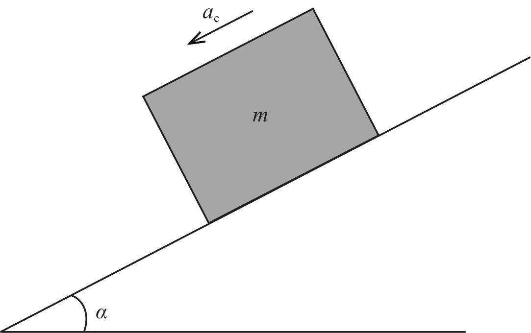
图 2 滑坡滑动体示意图(修改自 Jibson et al, 2000)
Figure 2. Sliding-block model used for the Newmark analysis (revised from Jibson et al, 2000)
![]()
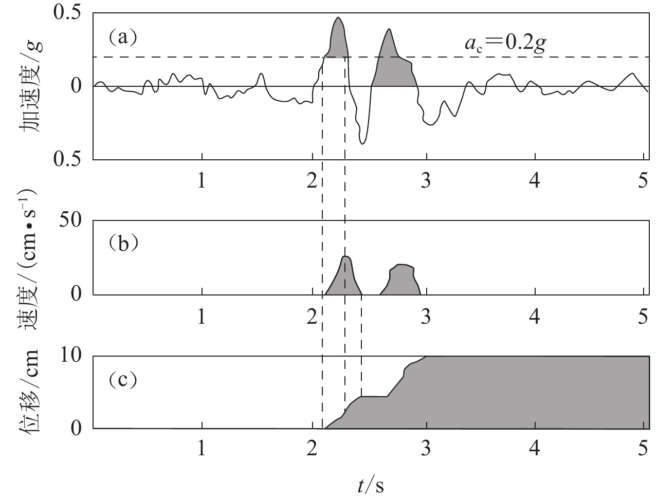
图 3 Newmark模型累积位移求解原理示意图(修改自Wilson和Keefer,1983)
(a) 地震动加速度时程曲线;(b) 滑动速度时程曲线;(c) 滑块累积位移时程曲线
Figure 3. Illustration of Newmark double-integration (revised from Wilson and Keefer,1983)
(a) Acceleration time history of seismic ground motion with the critical acceleration;(b) Velocity time history of landslide block;(c) Displacement time history of landslide block
![]()
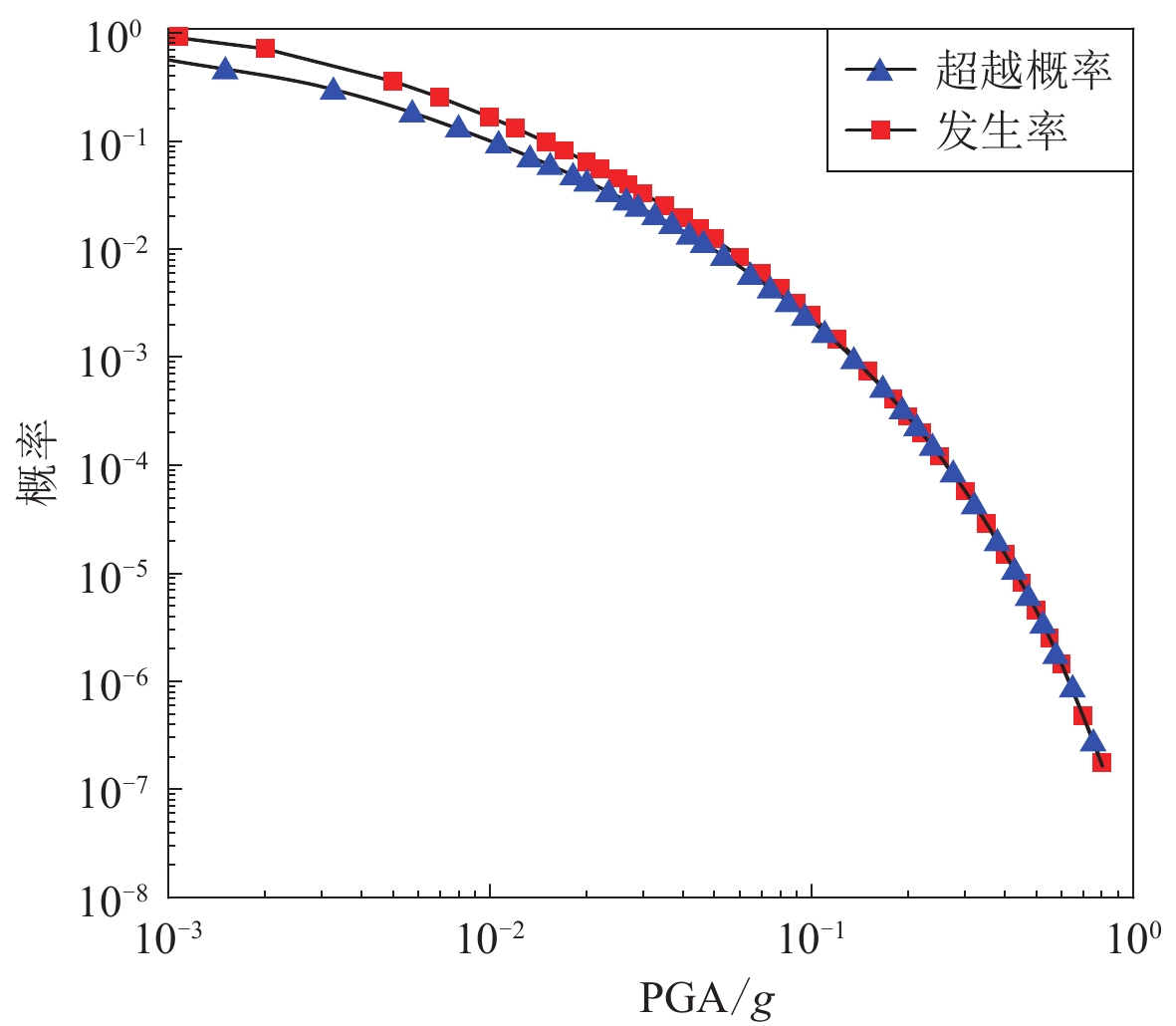
图 4 地震发生率曲线与超越概率曲线
Figure 4. Earthquake incidence curve and probability of exceedance curve
![]()
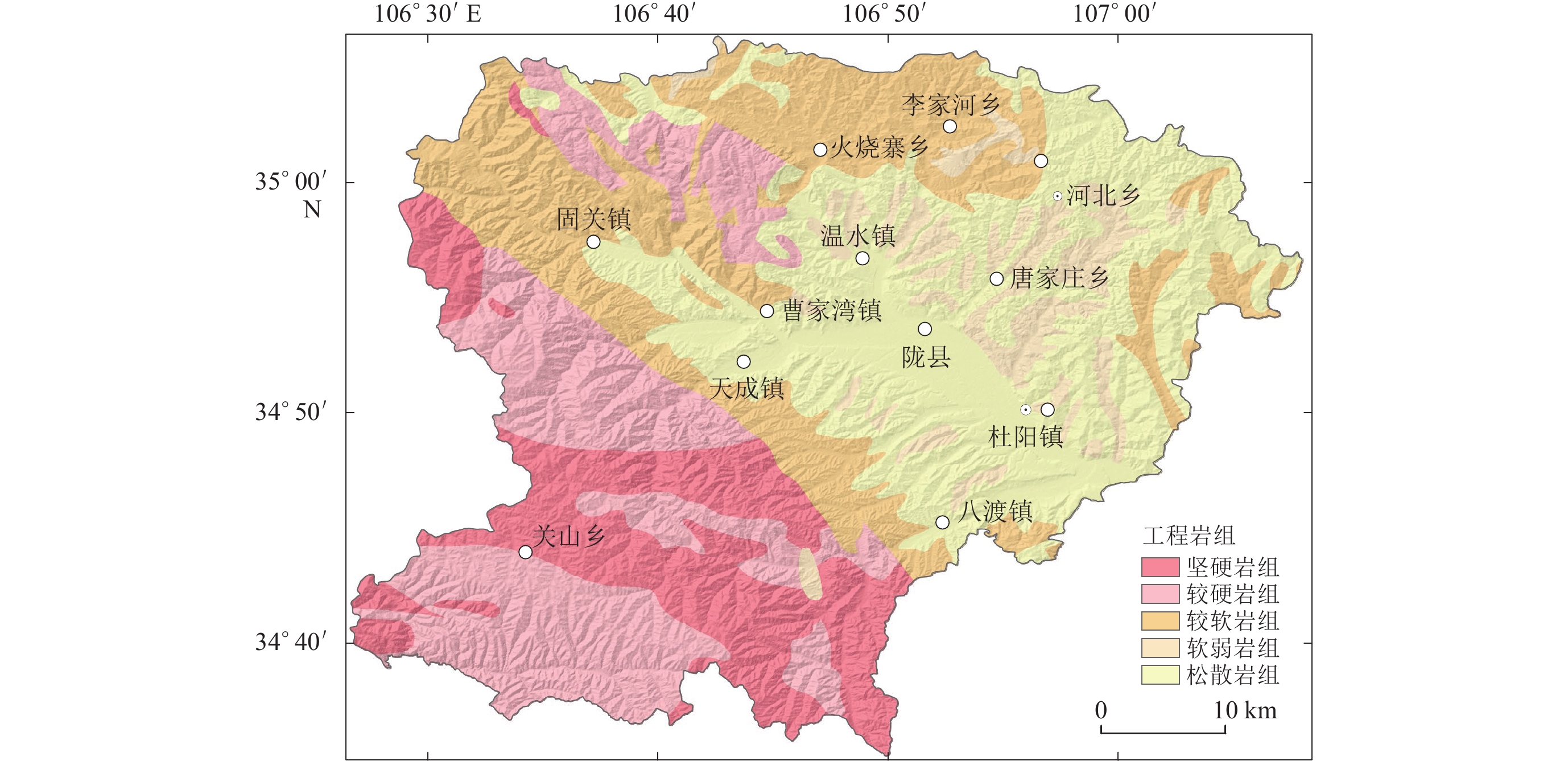
图 5 研究区工程岩组分类图(引自Jibson et al,2000)
Figure 5. The rock groups based on rock strength of the study area (after Jibson et al,2000)
![]()
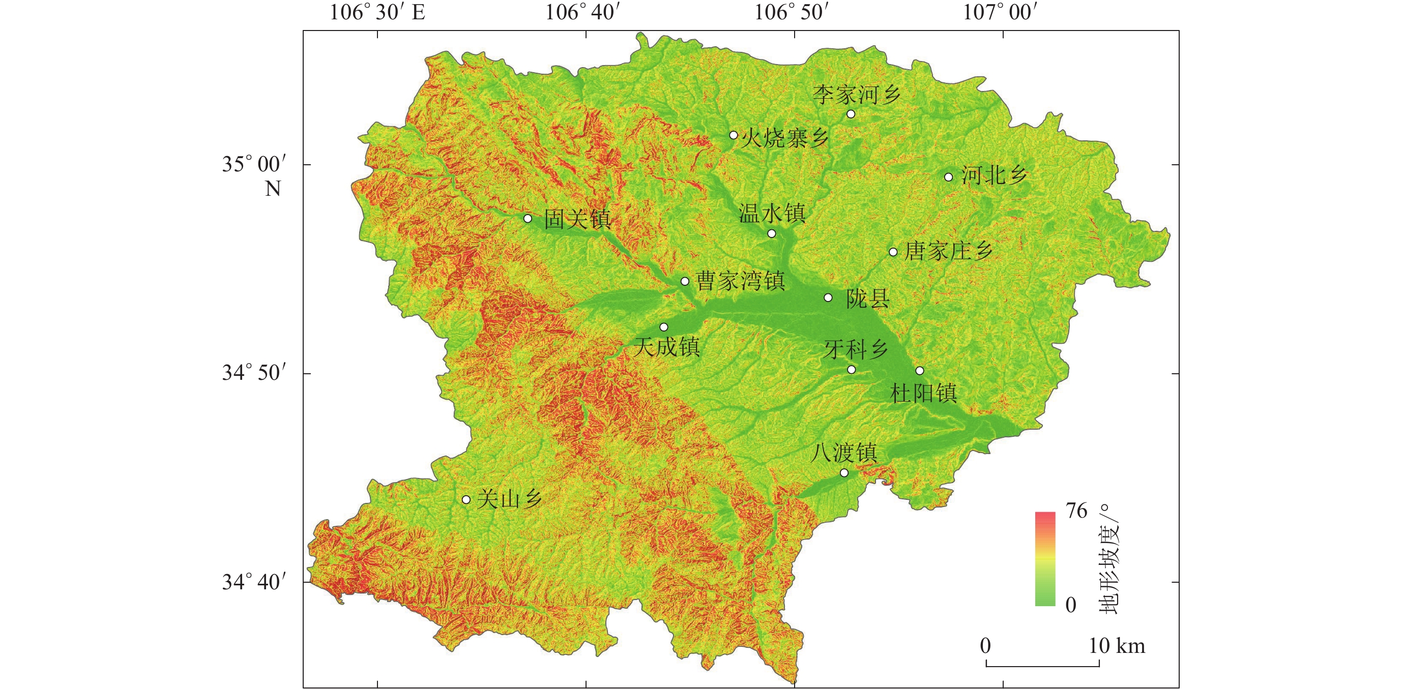
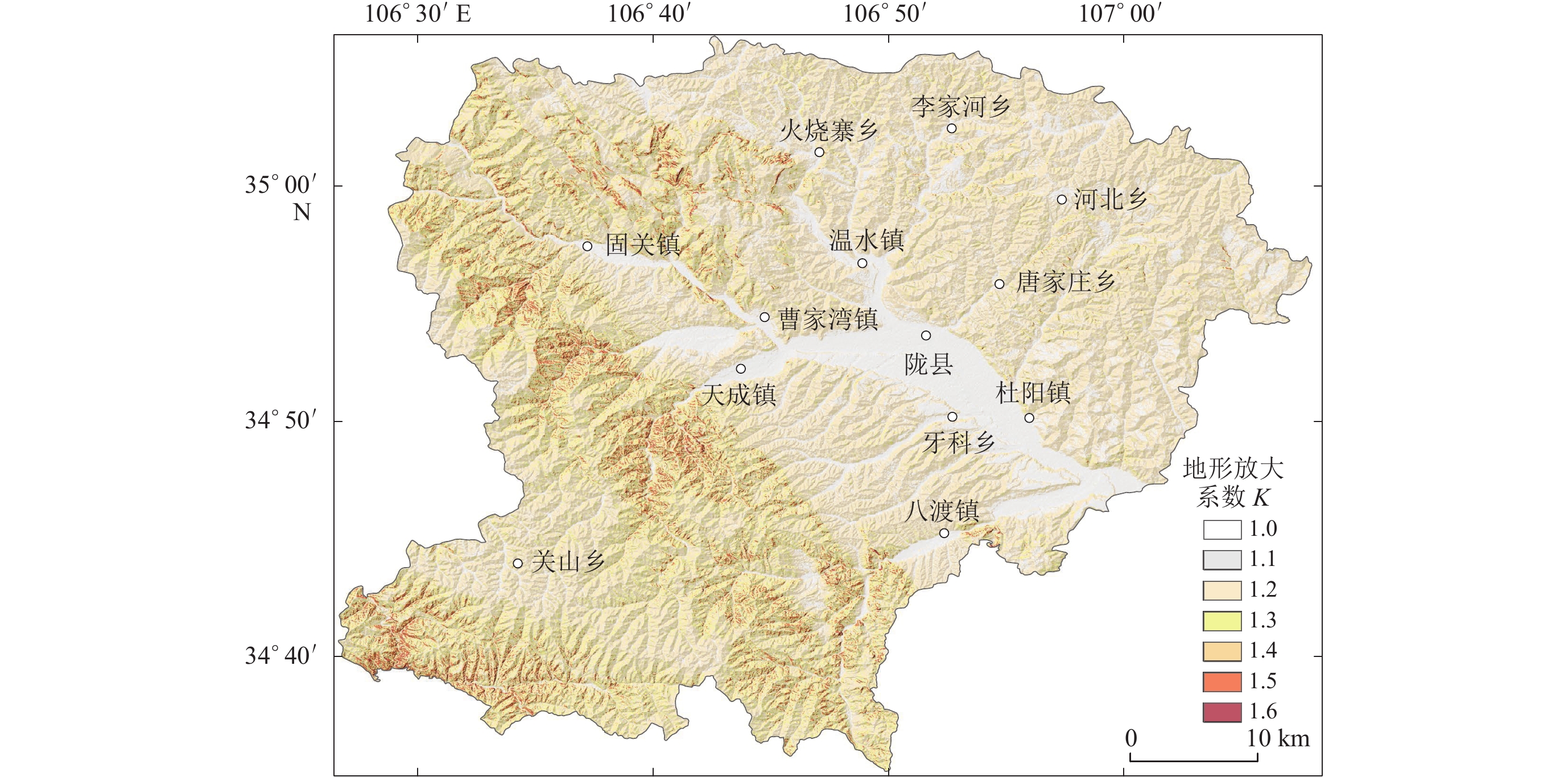
图 8 研究区50年10%超越概率水平的地震动峰值加速度
(a) 未考虑地形放大效应;(b) 考虑地形放大效应
Figure 8. The peak ground motion under the 10% exceedance probability of incidence rate in 50 years of study areas
(a) Considering topography amplification effects;(b) Without considering topography amplification effects
![]()
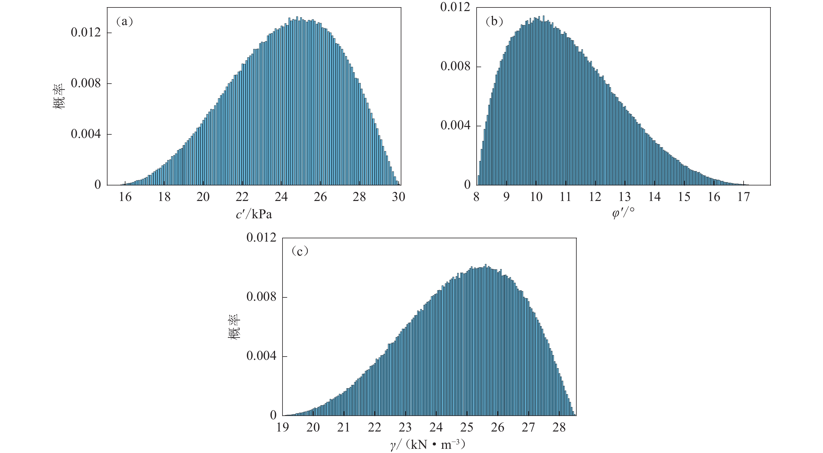
图 9 工程岩组内聚力c′ (a)、内摩擦角φ′ (b)以及岩体的物质重度γ (c)的蒙特卡洛抽样结果
Figure 9. Examples of the Monte Carlo simulations of effective cohesion c′ (a),effective internal friction angle φ′ (b) and density γ (c) of the rock
![]()
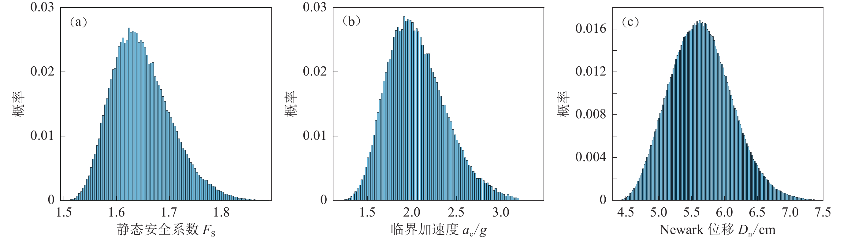
图 10 静态安全系数Fs、临界加速度ac以及Newmark位移 Dn的蒙特卡洛抽样结果
Figure 10. Examples of the Monte Carlo simulations of static safety factor Fs (a),critical acceleration ac (b) and Newmark displacement Dn (c)
![]()
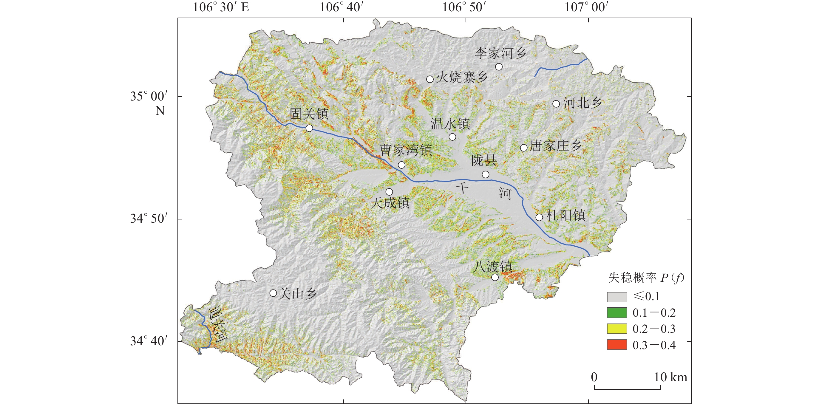
图 11 研究区地震滑坡失稳概率图
Figure 11. Instability probability map of earthquake-induced landslide of the study area
表 1 考虑地形放大效应的经验取值
Table 1 The empirical parameters considering the topographic amplification effect
突出地形的高度 H/m 局部突出台地边缘的侧向平均坡降H/L 非岩质地层 岩质地层 H/L<0.3 0.3≤H/L<0.6 0.6≤H/L<1.0 H/L≥1.0 H<5 H<20 0 0.1 0.2 0.3 5≤H<15 20≤H<40 0.1 0.2 0.3 0.4 15≤H<25 40≤H<60 0.2 0.3 0.4 0.5 H≥25 H≥60 0.3 0.4 0.5 0.6 注:H/L是坡度的正切值。  下载: 导出CSV
表 2 基于Newmark模型的工程地质岩性的β-PERT分布
Table 2 β-PERT distribution of the engineering geological lithology with the Newmark model
工程岩组 c′/kPa φ′/° γ /(kN·m−3) 最小值 最可能值 最大值 最小值 最可能值 最大值 最小值 最可能值 最大值 Ⅰ 30 40 60 25 40 60 23.5 27.5 32.5 Ⅱ 28 35 40 15 35 50 21.5 26.5 30.5 Ⅲ 20 28 32 12 20 30 19.5 24.5 28.5 Ⅳ 15 25 30 10 20 40 18.5 25.5 28.5 Ⅴ 8 10 15 8 10 18 15.5 21.5 25.5 注:t=3 m; γw=9.807 kN/m3
下载: 导出CSV
-
陈庆宇,熊仁伟,田勤俭. 2018. 陇县—岐山—马召断裂几何结构特征[J]. 地震,38(3):66–80. doi: 10.3969/j.issn.1000-3274.2018.03.007 Chen Q Y,Xiong R W,Tian Q J. 2018. Segmentary characteristics of the geometrical structure of the Longxian-Qishan-Mazhao active fault[J]. Earthquake,38(3):66–80 (in Chinese).
杜兴信,张春生. 1992. 鄂尔多斯周缘地震带地震活动的分期和相关分析[J]. 地震研究,15(2):135–144. Du X X,Zhang C S. 1992. Period dividing and correlation analysis of seismicity in the seismic zones around the Erdos block[J]. Journal of Seismological Research,15(2):135–144 (in Chinese).
国家技术监督局, 中华人民共和国建设部. 1995. GB 50218—94 工程岩体分级标准[S]. 北京: 中国计划出版社: 68−69. State Bureau of Quality and Technical Supervision, Ministry of Construction of the People’s Republic of China. 1995. GB 50218−94 Standard for Engineering Classification of Rock Masses[S]. Beijing: China Planning Press: 68−69 (in Chinese).
黄润秋,李为乐. 2009. 汶川地震触发崩塌滑坡数量及其密度特征分析[J]. 地质灾害与环境保护,20(3):1–7. doi: 10.3969/j.issn.1006-4362.2009.03.001 Huang R Q,Li W L. 2009. Analysis on the number and density of landslides triggered by the 2008 Wenchuan earthquake,China[J]. Journal of Geological Hazards and Environment Preservation,20(3):1–7 (in Chinese).
高孟潭. 2015. GB 18306—2015《中国地震动参数区划图》宣贯教材[M]. 北京: 中国质检出版社: 138−142. Gao M T. 2015. Teaching Book for GB18306−2015 Seismic Ground Motion Parameters Zonation Map of China[M]. Beijing: China Quality Inspection Press: 138−142 (in Chinese).
李雪婧,高孟潭,徐伟进. 2019. 基于Newmark模型的概率地震滑坡危险性分析方法研究:以甘肃天水地区为例[J]. 地震学报,41(6):795–807. doi: 10.11939/jass.20180075 Li X J,Gao M T,Xu W J. 2019. Probabilistic seismic slope displacement hazard analysis based on Newmark displacement model:Take the area of Tianshui,Gansu Province,China as an example[J]. Acta Seismologica Sinica,41(6):795–807 (in Chinese).
刘甲美. 2016. 概率地震滑坡危险性区划方法及应用[J]. 国际地震动态,(1):45–46. Liu J M. 2016. The method and application of probabilistic seismic hazard assessment for sliding displacement of slopes[J]. Recent Developments in World Seismology,(1):45–46 (in Chinese).
刘甲美,高孟潭,吴树仁. 2016. 概率性地震滑坡危险性区划方法及其应用[J]. 岩石力学与工程学报,35(增刊1):3100–3110. doi: 10.13722/j.cnki.jrme.2015.0118 Liu J M,Gao M T,Wu S R. 2016. Probabilistic seismic landslide hazard zonation method and its application[J]. Chinese Journal of Rock Mechanics and Engineering,35(S1):3100–3110 (in Chinese).
马思远,许冲,王涛,刘甲美. 2019. 应用2类Newmark简易模型进行2008年汶川地震滑坡评估[J]. 地震地质,41(3):774–788. doi: 10.3969/j.issn.0253-4967.2019.03.015 Ma S Y,Xu C,Wang T,Liu J M. 2019. Application of two simplified Newmark models to the assessment of landslides triggered by the 2008 Wenchuan earthquake[J]. Seismology and Geology,41(3):774–788 (in Chinese).
潘华. 2002. 概率地震危险性分析中参数不确定性研究[J]. 国际地震动态,(2):16–17. doi: 10.3969/j.issn.0253-4975.2002.02.010 Pan H. 2002. Study on uncertainty in parameters of probability seismic hazard analysis[J]. Recent Developments in World Seismology,(2):16–17 (in Chinese).
孙军杰,王兰民,龙鹏伟,陈光齐. 2011. 地震与降雨耦合作用下区域滑坡灾害评价方法[J]. 岩石力学与工程学报,30(4):752–760. Sun J J,Wang L M,Long P W,Chen G Q. 2011. An assessment method for regional susceptibility of landslides under coupling condition of earthquake and rainfall[J]. Chinese Journal of Rock Mechanics and Engineering,30(4):752–760 (in Chinese).
王师迪,师亚芹,董云鹏. 2018. 青藏高原东北缘固关—虢镇断裂中段第四纪以来活动特征[J]. 地质科学,53(3):781–798. doi: 10.12017/dzkx.2018.044 Wang S D,Shi Y Q,Dong Y P. 2018. The active characteristics in the Quaternary period of the middle Guguan-Guozhen fault,northeast margin of Qinghai-Tibet Plateau[J]. Chinese Journal of Geology,53(3):781–798 (in Chinese).
王涛,吴树仁,石菊松,辛鹏. 2013. 基于简化Newmark位移模型的区域地震滑坡危险性快速评估:以汶川MS8.0级地震为例[J]. 工程地质学报,21(1):16–24. doi: 10.3969/j.issn.1004-9665.2013.01.003 Wang T,Wu S R,Shi J S,Xin P. 2013. Case study on rapid assessment of regional seismic landslide hazard based on simplified Newmark displacement model:Wenchuan MS8.0 earthquake[J]. Journal of Engineering Geology,21(1):16–24 (in Chinese).
许冲,戴福初,徐锡伟. 2010. 汶川地震滑坡灾害研究综述[J]. 地质论评,56(6):860–874. doi: 10.16509/j.georeview.2010.06.017 Xu C,Dai F C,Xu X W. 2010. Wenchuan earthquake-induced landslides:An overview[J]. Geological Review,56(6):860–874 (in Chinese).
徐光兴,姚令侃,李朝红,王晓放. 2012. 基于汶川地震强震动记录的边坡永久位移预测模型[J]. 岩土工程学报,34(6):1131–1136. Xu G X,Yao L K,Li C H,Wang X F. 2012. Predictive models for permanent displacement of slopes based on recorded strong-motion data of Wenchuan earthquake[J]. Chinese Journal of Geotechnical Engineering,34(6):1131–1136 (in Chinese).
袁道阳,雷中生,刘小凤,刘百篪,才树华,郑文俊. 2004. 138年金城—陇西63/4级地震的史料考证与发震构造背景探讨[J]. 地震地质,26(1):52–60. Yuan D Y,Lei Z S,Liu X F,Liu B C,Cai S H,Zheng W J. 2004. Textual research on the historical data of the 138 AD Jincheng−Longxi M63/4 earthquake and discussion on its seismogenic structural background[J]. Seismology and Geology,26(1):52–60 (in Chinese).
中华人民共和国住房和城乡建设部. 2015. GB/T 50218—2014 工程岩体分级标准[S]. 北京: 中国计划出版社: 12. Ministry of Housing and Urban-Rural Development of the People’s Republic of China. 2015. GB/T 50218−2014 Standard for Engineering Classification of Rock Masses[S]. Beijing: China Planning Press: 12 (in Chinese).
中华人民共和国建设部. 2009. GB 50021—2001 岩土工程勘察规范(2009年版)[S]. 北京: 中国建筑工业出版社: 136−140. Ministry of Construction of the People’s Republic of China. 2009. GB 50021−2001 Code for Investigation of Geotechnical Engi-neering (2009 Edition)[S]. Beijing: China Architecture & Building Press: 136−140 (in Chinese).
中华人民共和国住房和城乡建设部, 中华人民共和国国家质量监督检验检疫总局. 2016. GB 50011—2010 建筑抗震设计规范[S]. 北京: 中国建筑工业出版社: 19–21. Ministry of Housing and Urban-Rural Development of the People’s Republic of China, General Administration of Quality Supervision, Inspection and Quarantine of the People’s Republic of China. 2010. GB 50011—2010 Code for Seismic Design of Buildings[S]. Beijing: China Architecture & Building Press: 19–21 (in Chinese).
Ambraseys N N,Menu J M. 1988. Earthquake-induced ground displacements[J]. Earthq Eng Struct Dyn,16(7):985–1006.
Cornell C A. 1968. Engineering seismic risk analysis[J]. Bull Seismol Soc Am,58(5):1583–1606. doi: 10.1785/BSSA0580051583
Dreyfus D,Rathje E M,Jibson R W. 2013. The influence of different simplified sliding-block models and input parameters on regional predictions of seismic landslides triggered by the Northridge earthquake[J]. Eng Geol,163:41–54. doi: 10.1016/j.enggeo.2013.05.015
Gallen S F,Clark M K,Godt J W,Roback K,Niemi N A. 2017. Application and evaluation of a rapid response earthquake-triggered landslide model to the 25 April 2015 MW7.8 Gorkha earthquake,Nepal[J]. Tectonophysics,714/715:173–187. doi: 10.1016/j.tecto.2016.10.031
Godt J W, Sener B, Verdin K L, Wald D, Earle P. 2008. Rapid assessment of earthquake-induced landsliding[C]//Global Promotion Committee of the International Programme on Landslides (IPL). Tokyo: United Nations University: 463−468.
Jibson R W,Keefer D K. 1993. Analysis of the seismic origin of landslides:Examples from the New Madrid seismic zone[J]. Geol Soc Am Bull,105(4):521–536.
Jibson R W. 2007. Regression models for estimating coseismic landslide displacement[J]. Eng Geol,91(2/3/4):209–218.
Jibson R W,Harp E L,Michael J A. 2000. A method for producing digital probabilistic seismic landslide hazard maps[J]. Eng Geol,58(3/4):271–289.
Jibson R W, Michael J A. 2009. Maps Showing Seismic Landslide Hazards in Anchorage, Alaska[R]. Reston: Center for Integrated Data Analytics Wisconsin Science Center: 1−9.
Keefer D K. 1984. Landslides caused by earthquakes[J]. Geol Soc Am Bull,95(4):406–421. doi: 10.1130/0016-7606(1984)95<406:LCBE>2.0.CO;2
Liu J M,Gao M T,Wu S R,Wang T,Wu J. 2016. A hazard assessment method for potential earthquake induced landslides:A case study in huaxian county,shaanxi province[J]. Acta Geologica Sinica,90(2):14.
Mankelow J M,Murphy W. 1998. Using GIS in the probabilistic assessment of earthquake triggered landslide hazards[J]. J Earthq Eng,2(4):593–623.
Newmark N M. 1965. Effects of earthquakes on dams and embankments[J]. Géotechnique,15(2):139–160.
Rathje E M, Saygili G. 2008. Probabilistic seismic hazard analysis for the sliding displacement of slopes:Scalar and vector approaches[J]. J Geotech Geoenviron Eng,134(6):804–814.
Rathje E M, Saygili G. 2009. Probabilistic assessment of earthquake-induced sliding displacements of natural slopes[J]. Bull N Z Soc Earthq,42(1):18–27.
Refice A,Capolongo D. 2002. Probabilistic modeling of uncertainties in earthquake-induced landslide hazard assessment[J]. Comput Geosci,28(6):735–749. doi: 10.1016/S0098-3004(01)00104-2
Urzúa A,Christian J T. 2013. Sliding displacements due to subduction-zone earthquakes[J]. Eng Geol,166:237–244. doi: 10.1016/j.enggeo.2013.08.005
Wang Y B,Rathje E M. 2015. Probabilistic seismic landslide hazard maps including epistemic uncertainty[J]. Eng Geol,196:313–324. doi: 10.1016/j.enggeo.2015.08.001
Wilson R C,Keefer D K. 1983. Dynamic analysis of a slope failure from the 6 August 1979 Coyote lake,California,earthquake[J]. Bull Seismol Soc Am,73(3):863–877. doi: 10.1785/BSSA0730030863
Xu C,Xu X W,Dai F C,Saraf A K. 2012. Comparison of different models for susceptibility mapping of earthquake triggered landslides related with the 2008 Wenchuan earthquake in China[J]. Comput Geosci,46:317–329. doi: 10.1016/j.cageo.2012.01.002
Xu Y R,Allen M B,Zhang W H,Li W Q,He H L. 2020. Landslide characteristics in the Loess Plateau,northern China[J]. Geomorphology,359:107150. doi: 10.1016/j.geomorph.2020.107150

计量
- 文章访问数: 467
- HTML全文浏览量: 225
- PDF下载量: 169
