

Formation mechanism and motion processes of the Aizigou giant paleolandslide,Jinshajiang river
-
摘要:
通过详细的野外调查,并结合遥感解译、室内试验以及数值模拟等手段,对矮子沟巨型古滑坡的基本特征、形成机制及运动演化过程进行了深入研究。矮子沟古滑坡的形成条件为:滑坡剪出口与坡脚之间存在巨大的高差,为滑坡的形成创造了良好的临空条件;顺向岸坡结构以及坡体内发育的多组控制性结构面是滑坡发生的结构基础;玄武岩系中的凝灰岩软弱夹层削弱了岩体的完整性,地表水及地下水长期入渗,水的软化作用降低了软弱夹层的抗剪强度;地震作用是造成岩体最终滑动失稳的关键因素。该滑坡的动力学过程可划分为四个阶段:① 启程活动阶段。斜坡地形效应使得地震波在斜坡上部表现出异常放大现象,当短时间内积聚的振动能量超过岩土体的强度时,易形成高位滑坡,滑坡的变形破坏机制为拉裂-滑移;② 近程活动阶段。近3.82×10⁸ m3的滑坡物质高位高速下滑,与矮子沟右岸坡体发生猛烈碰撞后进一步碎裂解体;③ 高速远程碎屑流阶段。碎屑流继续沿矮子沟高速运动约3 km;④ 堆积堵江阶段。滑坡物质最终形成体积为2.73×10⁸ m3的巨型堰塞坝,堵塞金沙江并形成堰塞湖,其回水区域向上游延续75 km至格勒一带。对金沙江矮子沟口上游河段采集到的堰塞湖沉积物进行光释光测年,结果指示该古滑坡发生于距今2.5万年左右。
Abstract:The Emeishan basalt group widely distributed in southwestern China is often considered as an ideal place for building large hydropower dams due to its deep canyon landforms. Historically, the large-scale high-position and long-distance landslides in Emeishan basalt have caused a large number of casualties, property damage and far-reaching environmental effects. Currently, there is no deep and systematic research for the development process of such landslides over the world, and it is still difficult to objectively access the risk of large-scale high-position landslides in southwestern China. Therefore, the study on the formation mechanism of large-scale high-position and long-distance landslides in Emeishan basalt has significant scientific and practical implication. The Aizigou paleolandslide, which represents a typical large basalt high-speed remote landslide, is located in the Liucheng section of the Lower Jinshajiang river, southwestern Sichuan Province, China. Geological investigation and interpretation of remote sensing imagery, in addition to experiments, numerical simulation, and geochronological dating were used to determine the formation mechanism and motion process of the landslide. Four factors were critical: a substantial height difference between the landslide shearing surface and the foot of the slope, multiple structural defects within the rock mass, a tuff intercalation in the basaltic series with long-term softening due to surface water and groundwater, and seismic activity. The dynamic behavior of the landslide is divided into four stages as follows. ① Seismic waves in the upper part of the slope were significantly amplified by the topography of the mountain. When the accumulation of vibrational energy over a short time period exceeded the strength of the rock mass, the landslide was formed easily. Accordingly, the deformation and failure mechanism was sliding and fracturing. ② Landslide materials with a volume of approximately 3.82×10⁸ m3 slid down from a high position at a high velocity, after which they disintegrated into a debris flow after colliding with the mountainside on the right bank of Aizigou valley. ③ The high-speed debris flow moved approximately 3 km downstream within Aizigou valley. ④ Landslide materials blocked the Jinshajiang river, thereby forming a large barrier dam with a volume of 2.73×10⁸ m3 and establishing a dammed lake behind the barrier dam; its backwater region reached 75 km upstream. An analysis of the landslide-dammed lake deposit samples via optically stimulated luminescence reveals that the landslide occurred approximately 25 thousand years ago.
-
-
![]()
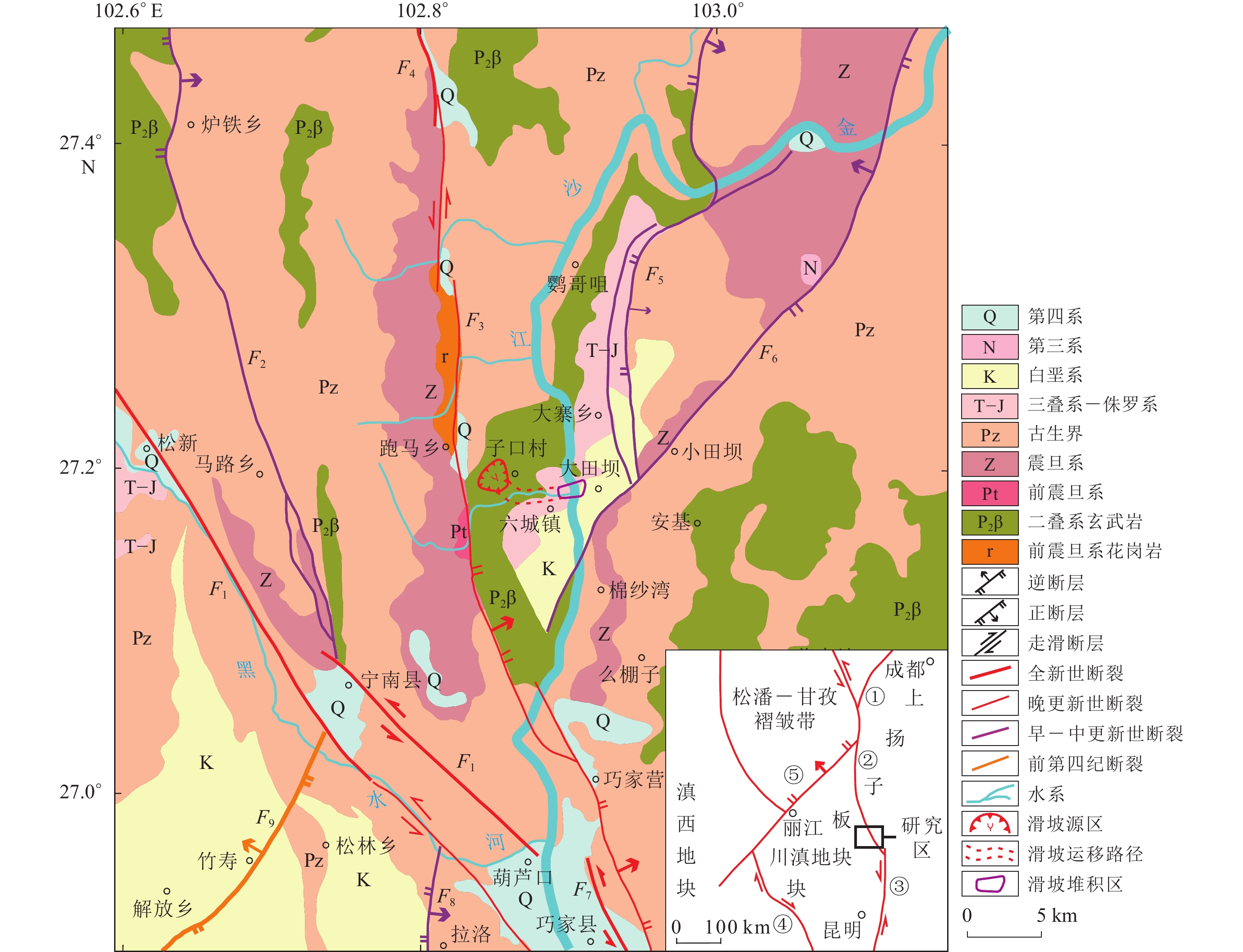
图 1 研究区地质图及构造背景图
F1:则木河断裂;F2:越西断裂;F3:四开—交际河断裂;F4:布拖断裂;F5:茂租断裂;F6:莲峰—巧家断裂;F7:小江断裂;F8:普渡河—大桥河断裂;F9:宁南—会理断裂。右下插图中:① 龙门山断裂带;② 则木河断裂带;③ 小江断裂带;④ 红河断裂带;⑤ 小金江断裂带
Figure 1. The geological map and tectonic settings of the study region
F1:Zemuhe fault;F2:Yuexi fault;F3:Sikai-Jiaojihe fault;F4:Butuo fault;F5:Maozu fault;F6:Lianfeng-Qiaojia fault;F7:Xiaojiang fault;F8:Puduhe-Daqiaohe fault;F9:Ningnan-Huili fault. Illustration in the lower right corner:① Longmenshan fault zone;② Zemuhe fault zone;③ Xiaojiang fault zone;④ Honghe fault zone;⑤ Xiaojinjiang fault zone
![]()
图 3 矮子沟古滑坡平面图(上)和剖面图(下)
Ⅰ :滑源区;Ⅱ :高位高速下滑区;Ⅲ :撞击碎裂区;Ⅳ :流通区;Ⅴ :堆积区
Figure 3. Geological map (upper) and cross section profile AB (lower) of the Aizigou paleolandslide
Ⅰ :Landslide source area;Ⅱ :High-position and high-speed sliding area;Ⅲ :Impact fragmentation area;Ⅳ :Transportation area;Ⅴ :Accumulation area
![]()
图 4 撞击碎裂区内及其相邻地区出露的玄武岩基岩
B1区和B2区为观测点#24至#25段出露的碎裂状玄武岩基岩;B3区和B4区为观测点#26至#27段出露的碎裂状玄武岩基岩;B5区为撞击碎裂区相邻地区出露的相对完整的玄武岩基岩
Figure 4. Basaltic bedrocks exposed in the impact fragmentation area and its adjacent areas
The subareas B1 and B2 are the cataclastic basalt bedrock outcropped at the section from the observation point #24 to point #25,the subareas B3 and B4 are those at the section from the point #26 to point #27,and the subarea B5 is the relatively intact basaltic bedrock adjacent to the impact fragmentation area
![]()
图 5 滑源区对岸坡体上的滑坡堆积物
C1区和C2区为玄武岩大块石、孤石分布区,C3区和C4区为撞击碎裂区中下部分布的滑坡堆积物
Figure 5. Parts of the landslide deposits distributed on the bank opposite to the landslide source area
The subareas C1 and C2 are an area with large rocks and boulders,and the subareas C3 and C4 are landslide deposits exposed in the middle and lower parts of the impact fragmentation area
![]()
图 7 #11调查点处的滑坡堆积物
Figure 7. Landslide deposits in excavation at the observation point #11
![]()
图 8 矮子沟出口段北侧坡体上广泛分布的滑坡堆积物
(a−i) 调查点#12,#13和#14处的滑坡堆积物;(j,k) 调查点#18处的滑坡堆积物;(l) 山脊处分布的玄武岩大块石
Figure 8. Massive landslide deposits widely distributed across the northern slope of the mouth of Aizigou valley
(a−i) Landslide deposits at the observation points #12,#13,and #14;(j,k) Landslide deposits at the observation point #18;(l) Large basaltic boulders distributed on the ridge
![]()
图 9 金沙江右岸坡体上广泛分布的滑坡堆积物
(a,b) 调查点#2处的滑坡堆积物;(d,e) 调查点#3处的滑坡堆积物;(c,f) 调查点6#处已出现泥化现象的部分玄武岩块碎石;(g,h,j,k) 调查点#7处的滑坡堆积物;(i,l) 金沙江右岸坡体平台处分布的玄武岩大块石
Figure 9. Massive landslide deposits widely distributed on the right bank of Jinshajiang river
(a,b) Landslide deposits at observation point #2;(d,e) Landslide deposits at observation point #3;(c,f) The basaltic blocks showing severe argillitization at observation point #6;(g,h,j, k) Landslide deposits at observation point #7;(i,l) Large basaltic boulders distributed on a platform on the right bank of Jinshajiang river
![]()
图 10 金沙江两岸出露的古堰塞湖沉积物
(a) 古堰塞湖沉积物分布;(b) 新场出露的粉土层;(c) 葫芦口出露的完整的堰塞湖沉积物;(d) 金堂出露的粗砂层;(e) 格勒出露的砂砾石层
Figure 10. The ancient dammed lake sediments exposed along both banks of Jinshajiang river
(a) Distribution of the ancient dammed lake sediments;(b) Silt layers at Xinchang;(c) Dammed lake sediments at Hulukou;(d) Coarse sand layers at Jintang;(e) Sand gravel layers at Gele
![]()
图 12 矮子沟古滑坡的3D离散元数值模型
Figure 12. The 3D discrete element model of the Aizigou paleolandslide
![]()
图 13 边界条件及监测点A1−A5和B1−B6示意图
Figure 13. Boundary conditions and distribution of monitoring points A1−A5 and B1−B6 of 3DEC model
![]()
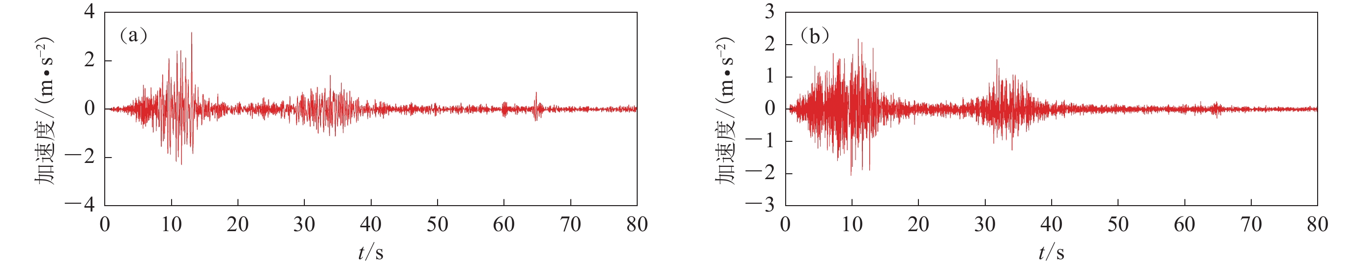
图 14 地震波水平向(a)、竖直向(b)加速度时程曲线
Figure 14. Acceleration time-history curves in horizontal (a) and vertical (b) directions
![]()
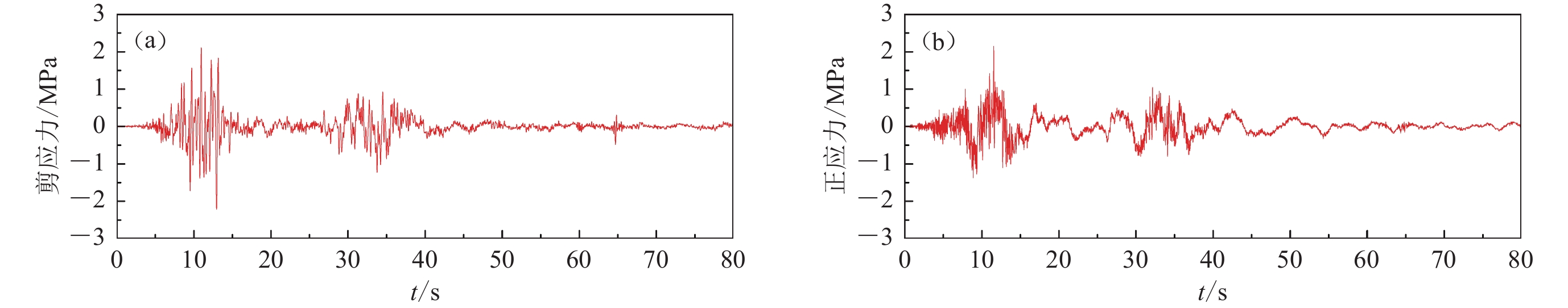
图 15 施加的地震动力荷载
(a) 水平向剪应力时程曲线;(b) 竖直向正应力时程曲线
Figure 15. Applied seismic dynamic loads
(a) Time history curve of horizontal shear stress;(b) Time history curve of vertical normal stress
![]()
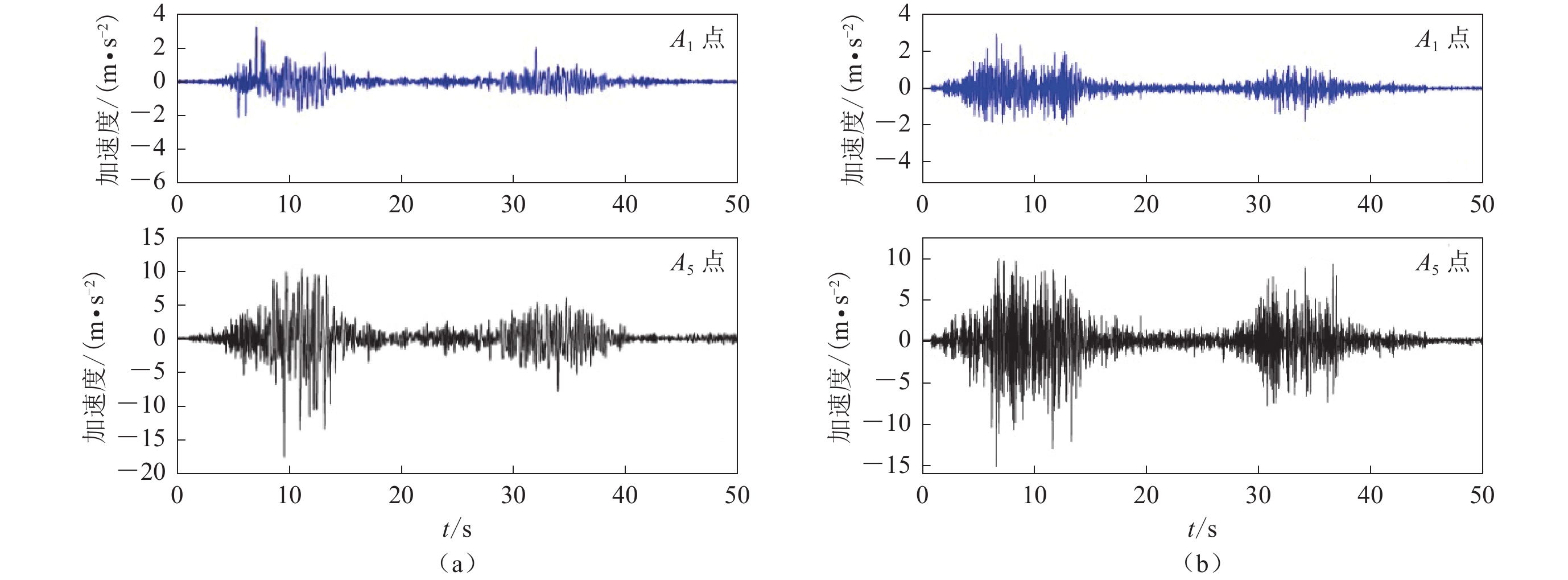
图 17 监测点A1和A5的水平向(a)、竖直向(b)加速度时程曲线
Figure 17. Horizontal (a) and vertical (b) acceleration time-history curves of monitoring points A1 and A5
![]()
图 18 滑坡在不同阶段的运动状态
(a) 在启程活动阶段,滑坡体发生明显的变形和错动;(b) 锁固段岩体被剪断,滑坡体启动;(c) 在近程活动阶段,滑坡体高位高速下滑;(d) 滑坡体高速下滑过程中,与矮子沟右岸坡体发生猛烈碰撞后进一步碎裂解体转化为碎屑流;(e,f) 滑坡碎屑流继续沿矮子沟高速滑动,进入高速远程滑动阶段;(g) 滑坡最终堵塞金沙江河道,形成堰塞湖
Figure 18. Movement states of the landslide at different running periods in the numerical model
(a) In the set-out stage,the head scarp of the landslide ruptured with an obvious deformation;(b) The rock mass of the locked segment was sheared off and the body started sliding;(c) The landslide maintained a high speed after its violent start at a high altitude,and slid down with increasing velocity in the short-range stage;(d) Landslide materials disintegrated into a debris flow after colliding with the mountainside along the right bank of Aizigou valley;(e,f) The debris flow continued to move down along Aizigou valley at a high speed and entered the rapid and long-runout debris flow stage;(g) The landslide blocked the Jinshajiang river,and formed a lake
表 1 金沙江下游六城段河谷演化阶段(黄典等,2010;韩刚等,2011)
Table 1 Valley evolution stages in the Liucheng section of the lower Jinshajiang river (Huang et al,2010;Han et al,2011)
地貌类型 河拔高度/m 高程/m 地质年代 形成时代/ka Ⅳ级阶地 250 830 ${\rm{Q}}_{{\rm{p}}}^{2}$ 180 Ⅲ级阶地 140 720 ${\rm{Q} }_{ {\rm{p} } }^{2} $ 150 Ⅱ级阶地 100 680 ${\rm{Q} }_{ {\rm{p} } }^{3} $ 39 Ⅰ级阶地 20 600 ${\rm{Q} }_{ {\rm{h} } } $ 11  下载: 导出CSV
表 2 滑坡堰塞湖沉积物样品的光释光测年数据
Table 2 Optically stimulated luminescence dating of the landslide-dammed lake deposit samples
实验室编号 采样地点 K含量 Th含量/10−6 U含量/10−6 质量含水量 年龄/ka 年龄误差/ka 17 124-1 六城镇 1.76% 8.66 1.78 2.22% 6.8 0.7 17 124-2 新场 2.92% 12.20 2.26 2.03% 10.0 0.1 17 124-3 棉纱村 2.85% 12.90 3.02 5.72% 15.7 1.6 17 124-4 葫芦口 0.25% 11.83 0.54 22.20% 20.3 1.5 17 124-5 葫芦口 1.74% 12.30 1.85 6.27% 20.5 1.7 17 124-6 葫芦口 1.73% 12.4 1.89 5.41% 25.7 2.9 17 124-7 大崇 1.50% 8.28 1.41 5.64% 20.3 2.2 17 124-8 金堂 1.43% 9.85 1.78 16.53% 12.7 1.4 17 124-9 蒙姑 1.63% 11.80 2.02 14.75% 13.3 1.2 17 124-10 格勒村 1.74% 7.28 1.68 8.33% 19.6 2.3
下载: 导出CSV
岩性 天然密度
/(kg·m−3)黏聚力
/MPa内摩擦角
/°体积模量
/GPa剪切模量
/GPa微风化玄武岩 2950 12.9 55 45.8 21.2 弱风化玄武岩 2860 9.8 45 31.6 17.3
下载: 导出CSV
结构面 法向刚度
/(GPa·m−1)切向刚度
/(GPa·m−1)内摩擦角
/°黏聚力
/MPa抗拉强度
/MPa节理面 26 19 20 1.2 0.03 滑面 9 6 15 0.5 0.01
下载: 导出CSV
表 5 监测点A1,A2,···,A5的峰值加速度及放大系数
Table 5 PGAs and their amplification coefficients of the monitoring points A1,A2,···,A5
监测点号 PGA/(m·s−2) PGA放大系数 水平向 竖直向 水平向 竖直向 A1 3.24 2.77 1.08 1.31 A2 4.68 3.95 1.56 1.87 A3 −7.02 −4.46 2.34 2.11 A4 −8.37 6.75 2.79 3.20 A5 −17.46 −14.24 5.82 6.75
下载: 导出CSV
-
程谦恭,胡厚田,胡广韬,彭建兵. 2000. 高速岩质滑坡临床弹冲与峰残强降复合启程加速动力学机理[J]. 岩石力学与工程学报,19(2):173–176. doi: 10.3321/j.issn:1000-6915.2000.02.010 Cheng Q G,Hu H T,Hu G T,Peng J B. 2000. A study of complex accelerated dynamics mechanism of highspeed landslide by elastic rocky impulse and peak-residual strength drop[J]. Chinese Journal of Rock Mechanics and Engineering,19(2):173–176 (in Chinese).
方健,尹小涛,周磊,严飞. 2017. 金沙江中游凝灰岩强度参数综合识别研究[J]. 应用力学学报,34(3):507–513. Fang J,Yin X T,Zhou L,Yan F. 2017. Comprehensive study on strength parameters of the tuff at Jinshajiang grand bridge site on Huali freeway[J]. Chinese Journal of Applied Mechanics,34(3):507–513 (in Chinese).
中国地震局. 2020. GB/T 17742—2020中国地震烈度表[S]. 北京: 中国标准出版社: 5–7. China Earthquake Administration. 2020. GB/T 17742−2020 The Chinese Seismic Intensity Scale[S]. Beijing: Standards Press of China: 5–7 (in Chinese).
韩刚,赵其华,彭社琴. 2011. 白鹤滩水电站坝区深部破裂岩体地应力演化特征[J]. 岩土力学,32(增刊1):583–589. doi: 10.16285/j.rsm.2011.s1.107 Han G,Zhao Q H,Peng S Q. 2011. In-situ stress field evolution of deep fracture rock mass at dam area of Baihetan hydropower station[J]. Rock and Soil Mechanics,32(S1):583–589 (in Chinese).
韩刚. 2015. 一类不对称发育的深部变形破裂成因机理: 以白鹤滩水电站坝址区深部变形破裂为例[D]. 成都: 成都理工大学: 57–60. Han G. 2015. A Type of Asymmetric Distributed Deep-Seated Crack Formation Mechanism: A Case Study of Baihetan Hydropower Station[D]. Chengdu: Chengdu University of Technology: 57–60 (in Chinese).
胡广韬. 1995. 滑坡动力学[M]. 北京: 地质出版社: 75–76. Hu G T. 1995. Landslide Dynamics[M]. Beijing: Geological Publishing House: 75–76 (in Chinese).
胡卸文,黄润秋,施裕兵,吕小平,朱海勇,汪雪瑞. 2009. 唐家山滑坡堵江机制及堰塞坝溃坝模式分析[J]. 岩石力学与工程学报,28(1):181–189. doi: 10.3321/j.issn:1000-6915.2009.01.024 Hu X W,Huang R Q,Shi Y B,Lü X P,Zhu H Y,Wang X R. 2009. Analysis of blocking river mechanism of Tangjiashan landslide and dam-breaking mode of its barrier dam[J]. Chinese Journal of Rock Mechanics and Engineering,28(1):181–189 (in Chinese).
黄典,杨达源,李郎平,石安池,陆飞,葛兆帅,胥勤勉. 2010. 金沙江白鹤滩河段下切速率初步研究[J]. 第四纪研究,30(5):872–876. doi: 10.3969/j.issn.1001-7410.2010.05.03 Huang D,Yang D Y,Li L P,Shi A C,Lu F,Ge Z S,Xu Q M. 2010. Incision rates of the Baihetan section of the Jinsha river[J]. Quaternary Sciences,30(5):872–876 (in Chinese).
黄润秋. 2009. 汶川地震地质灾害研究[M]. 北京: 科学出版社: 233–235 Huang R Q. 2009. Geohazard Assessment of the Wenchuan Earthquake[M]. Beijing: Science Press: 233–235 (in Chinese).
李国和,王思敬,孙承志. 2001. 金沙江水电开发区域工程地质环境综合评价[J]. 地球科学:中国地质大学学报,26(3):309–313. Li G H,Wang S J,Sun C Z. 2001. Comprehensive assessment of engineering geological environment in hydroelectric development zone,Jinshajiang River[J]. Earth Science: Journal of China University of Geosciences,26(3):309–313 (in Chinese).
李坪. 1993. 鲜水河—小江断裂带[M]. 北京: 地震出版社: 23–25. Li P. 1993. Xianshuihe and Xiaojiang Fault Zones[M]. Beijing: Seismological Press: 23–25 (in Chinese).
李忠生. 2003. 国内外地震滑坡灾害研究综述[J]. 灾害学,18(4):64–70. doi: 10.3969/j.issn.1000-811X.2003.04.013 Li Z S. 2003. The state of the art of the research on seismic landslide hazard at home and abroad[J]. Journal of Catastrophology,18(4):64–70 (in Chinese).
王刚,王二七. 2005. 挤压造山带中的伸展构造及其成因:以滇中地区晚新生代构造为例[J]. 地震地质,27(2):188–199. doi: 10.3969/j.issn.0253-4967.2005.02.002 Wang G,Wang E Q. 2005. Extensional structures within the compressional orogenic belt and its mechanism:A case study for the Late Cenozoic deformation in Central Yunnan[J]. Seismology and Geology,27(2):188–199 (in Chinese).
文宝萍,王凡. 2021. 1965年烂泥沟滑坡前兆、高速远程运动及后期演化特征[J]. 水文地质工程地质,48(6):72–80. doi: 10.16030/j.cnki.issn.1000-3665.202108065 Wen B P,Wang F. 2021. Precursors and motion characteristics of the 1965 Lannigou rockslides and the subsequent evolution[J]. Hydrogeology and Engineering Geology,48(6):72–80 (in Chinese).
吴昊,裴向军,崔圣华,黄润秋,宋词. 2021. 强震山区滑坡发育分布的地形地质控制作用研究[J]. 岩石力学与工程学报,40(5):972–986. doi: 10.13722/j.cnki.jrme.2020.0944 Wu H,Pei X J,Cui S H,Hung R Q,Song C. 2021. Study of topographic and geological controls on landslide development and distribution within mountainous regions influenced by strong earthquakes[J]. Chinese Journal of Rock Mechanics and Engineering,40(5):972–986 (in Chinese).
邢爱国,胡厚田,杨明. 2002. 大型高速滑坡滑动过程中摩擦特性的试验研究[J]. 岩石力学与工程学报,21(4):522–525. doi: 10.3321/j.issn:1000-6915.2002.04.014 Xing A G,Hu H T,Yang M. 2002. Testing study on frictional characteristic of large-scale and high-speed landslide during sliding[J]. Chinese Journal of Rock Mechanics and Engineering,21(4):522–525 (in Chinese).
邢爱国,陈龙珠,陈明中. 2004. 岩石力学特性分析与高速滑坡启动速度预测[J]. 岩石力学与工程学报,23(10):1654–1657. doi: 10.3321/j.issn:1000-6915.2004.10.012 Xing A G,Chen L Z,Chen M Z. 2004. Analysis on mechanical properties of rock and prediction of muzzle velocity of high-speed landslide[J]. Chinese Journal of Rock Mechanics and Engineering,23(10):1654–1657 (in Chinese).
胥良. 2004. 金沙江白鹤滩水电站金江滑坡成因机制及稳定性研究[D]. 成都: 成都理工大学: 72–75. Xu L. 2004. A Study on Genetic Mechanism and Stability of Jinjiang Landslide at the Baihetan Hydropower Station in the Jinsha River[D]. Chengdu: Chengdu University of Technology: 72–75 (in Chinese).
徐湘涛. 2012. 金沙江白鹤滩水电站高边坡岩体力学特性及其稳定性研究[D]. 成都: 成都理工大学: 35–36. Xu X T. 2012. Research on Rock Mass Mechanical Characteristics and Stability of High Slope of Baihetan Hydropower Station[D]. Chengdu: Chengdu University of Technology: 35–36 (in Chinese).
殷跃平,王猛,李滨,冯振. 2012. 汶川地震大光包滑坡动力响应特征研究[J]. 岩石力学与工程学报,31(10):1969–1982. doi: 10.3969/j.issn.1000-6915.2012.10.003 Yin Y P,Wang M,Li B,Feng Z. 2012. Dynamic response characteristics of Daguangbao landslide triggered by Wenchuan earthquake[J]. Chinese Journal of Rock Mechanics and Engineering,31(10):1969–1982 (in Chinese).
云南省巧家县志编纂委员会. 1997. 巧家县志[M]. 昆明: 云南人民出版社: 61–63. Chorography Compilation Committee of Qiaojia. 1997. History of Qiaojia[M]. Kunming: People’s Press of Yunnan: 61–63 (in Chinese).
张明,王正波,孙琳. 2016. 滑坡碎屑流高速远程机制环剪试验研究[J]. 岩石力学与工程学报,35(增刊1):2673–2681. doi: 10.13722/j.cnki.jrme.2014.1609 Zhang M,Wang Z B,Sun L. 2016. Research on rapid and long-runout mechanisms of rockslide debris using ring shear tests[J]. Chinese Journal of Rock Mechanics and Engineering,35(S1):2673–2681 (in Chinese).
张曙光. 2007. 金沙江白鹤滩水电站高拱坝建设工程地质适宜性研究[D]. 成都: 成都理工大学: 31–32. Zhang S G. 2007. Engineering Geological Feasibility Study of High Arch Dam Construction at Baihetan Hydropower Station, Jinsha River[D]. Chengdu: Chengdu University of Technology: 31–32 (in Chinese).
张欣,王运生. 2017. 白鹤滩水电站库区小江断裂带活动性研究[J]. 工程地质学报,25(2):531–540. doi: 10.13544/j.cnki.jeg.2017.02.033 Zhang X,Wang Y S. 2017. Activities of Xiaojiang fault zone in Baihetan hydropower station reservoir[J]. Journal of Engineering Geology,25(2):531–540 (in Chinese).
周洪福, 方甜, 韦玉婷. 2023. 国内外地震滑坡研究: 现状、问题与展望[J]. 沉积与特提斯地质, 43(3): 615−628. Zhou H F, Fang T, Wei Y T. 2023. Research situations and suggestions on earthquake-induced landslides[J]. Sedimentary Geology and Tethyan Geology, 43(3): 615−628 (in Chinese).
Cho S H,Kaneko K. 2004. Influence of the applied pressure waveform on the dynamic fracture processes in rock[J]. Int J Rock Mech Min Sci,41(5):771–784. doi: 10.1016/j.ijrmms.2004.02.006
Cui S H,Yang Q W,Pei X J,Huang R Q,Guo B,Zhang W F. 2020. Geological and morphological study of the Daguangbao landslide triggered by the MS8.0 Wenchuan earthquake,China[J]. Geomorphology,370:107394. doi: 10.1016/j.geomorph.2020.107394
Fan X M,Scaringi G,Korup O,West A J,van Westen C J,Tanyas H,Hovius N,Hales T C,Jibson R W,Allstadt K E,Zhang L M,Evans S G,Xu C,Li G,Pei X J,Xu Q,Huang R Q. 2019. Earthquake-induced chains of geologic hazards:Patterns,mechanisms,and impacts[J]. Rev Geophys,57(2):421–503. doi: 10.1029/2018RG000626
Hungr O,Leroueil S,Picarelli L. 2014. The Varnes classification of landslide types,an update[J]. Landslides,11(2):167–194. doi: 10.1007/s10346-013-0436-y
Keefer D K. 1984. Landslides caused by earthquakes[J]. GSA Bull,95(4):406–421. doi: 10.1130/0016-7606(1984)95<406:LCBE>2.0.CO;2
Liu W,He S M. 2016. A two-layer model for simulating landslide dam over mobile river beds[J]. Landslides,13(3):565–576. doi: 10.1007/s10346-015-0585-2
Richter C F. 1958. Elementary Seismology[M]. San Francisco: W. H. Freeman and Co: 21–23.
Valagussa A,Marc O,Frattini P,Crosta G B. 2019. Seismic and geological controls on earthquake-induced landslide size[J]. Earth Planet Sci Lett,506:268–281. doi: 10.1016/j.jpgl.2018.11.005


计量
- 文章访问数: 132
- HTML全文浏览量: 40
- PDF下载量: 39
